
Height 20 m Watercourse Henrys Fork | Total height 65 feet (20 m) Elevation 1,682 m | |
 | ||
Similar Upper Mesa Falls, Henrys Fork, Mesa Falls Scenic Byway, Harriman State Park, Rocky Mountains | ||
Nemoflow beater dayz lower mesa falls
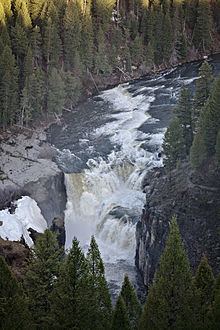
Lower Mesa Falls is a 65-foot (20 m) waterfall on the Henrys Fork in Fremont County, Idaho. It is located in the Caribou-Targhee National Forest on the Mesa Falls Scenic Byway. It is downstream of Upper Mesa Falls.
Contents
Map of Lower Mesa Falls, Idaho, USA
References
Lower Mesa Falls Wikipedia(Text) CC BY-SA