
Entrances 1 Entrance 1 | Depth 110m Length 4,100 m Discovery 3 October 1968 | |
 | ||
Difficulty Extensive system with tight strenuous sections Access Leader controlled by Mendip Caving Group; experienced cavers only Cave survey MCG Upper Flood Survey 2012 | ||
Upper flood swallet winning video and conference closing av hidden earth 2014
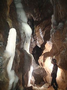
Upper Flood Swallet (grid reference ST50575576) which was originally known as Blackmoor Flood Swallet, is a cave near Charterhouse, in the carboniferous limestone of the Mendip Hills, in Somerset, England. The cave is part of the Cheddar Complex SSSI.
Contents
- Upper flood swallet winning video and conference closing av hidden earth 2014
- Upper flood swallet the journey to neverland part1
- The 2006 breakthrough
- References
The entrance was revealed in the Great Flood of 1968, giving the cave its name. It was dug consistently since then with breakthroughs occurring in 1971, 1972, 1985 and 2006.
As of September 2008 it is over 3.5 km in length and around 125 m deep.
Upper flood swallet the journey to neverland part1
The 2006 breakthrough
In September 2006 cavers squeezed through an excavated boulder choke into new passage. In a series of three digging trips they discovered 1.2 km of well decorated cave.
References
Upper Flood Swallet Wikipedia(Text) CC BY-SA