
Area 17,040 km² | ||
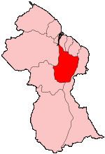 | ||
Upper Demerara-Berbice (Region 10) is a region of Guyana, bordering the regions of Essequibo Islands-West Demerara, Demerara-Mahaica and Mahaica-Berbice to the north, the region of East Berbice-Corentyne to the east, and the regions of Potaro-Siparuni and Cuyuni-Mazaruni to the west.
Contents
Map of Upper Demerara-Berbice, Guyana
It contains Guyana's second largest city, Linden, with other towns including Ituni, Kalkuni, Kwakwani, Kurupukari, Rockstone and Takama.
Kimbia is the very first training center to house the Guyana National Service. The Pioneer Corps was started in 1974, with the establishment of Kimbia Center on the Berbice River. Kimbia is located in the Ebini Area, very close to the Ebini Agriculture Station.
Population
The Government of Guyana has administered three official censuses since the 1980 administrative reforms, in 1980, 1991 and 2002. In 2012, the population of Upper Demerara-Berbice was recorded at 39,452 people. Official census records for the population of the Upper Demerara-Berbice region are as follows:
Communities
(including name variants):