
Elevation 247 m (810 ft) Time zone CET (UTC+1) Postal code 06019 Dialling code 075 | Demonym(s) Umbertidesi Area 200 km² Local time Friday 5:32 AM | |
 | ||
Frazioni Badia, Calzolaro, Castelvecchio, Comunaglia, Leoncini, Mita, Molino Vitelli, Montecastelli, Niccone, Pierantonio, Polgeto, Preggio, Spedalicchio Weather 5°C, Wind N at 5 km/h, 87% Humidity | ||
Moschea a umbertide parla la gente a telecamera accesa e nascosta e il giorno di salvini
Umbertide is a town and comune (township) of Italy, in the province of Perugia in northwestern Umbria, at the confluence of the Reggia river and the Tiber. It is 30 km (19 mi) North of Perugia and 20 km (12 mi) South of Città di Castello. With 16,890 inhabitants according to the 2011 census, Umbertide is one of the larger towns of Umbria; and basically flat, which is relatively unusual for the region. It is an important regional industrial center producing machine tools, farm machinery, textiles, packaging material, and ceramics.
Contents
- Moschea a umbertide parla la gente a telecamera accesa e nascosta e il giorno di salvini
- Map of 06019 Umbertide Province of Perugia Italy
- History
- Main sights
- References
Map of 06019 Umbertide, Province of Perugia, Italy
History
Umbertide or the surrounding area was inhabited in pre-Roman and Roman times. At the top of Monte Acuto has been discovered an umbrian fortification ("castelliere"). The nineteenth‑century archaeologist Mariano Guardabassi even attributed a small building at Lame, about 1 km from the center of the modern town, to the Etruscans, although this is by no means certain The Roman town of Pitulum Mergens, destroyed by Totila in the mid-6th century, may account for Roman remains in S. Maria delle Sette. In its present incarnation, Umbertide was founded in the 8th or 10th century, depending on the scholar; its original name was Fratta, and it received its present name in 1863 in honor of then Crown Prince Umberto and of Uberto or Umberto margrave of Tuscany, whose four sons, Adalberto, Ingilberto, Benedetto o Bonifacio, according to tradition, rebuilt the town in 796 on the ruins of Pitulum Mergens.
Main sights
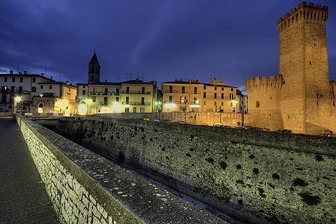
Although there are remains of the medieval walls, a few medieval houses, and part of the Rocca di Umbertide, or citadel, many of Umbertide's best monuments are of later periods.
Beyond the city limits, the township's principal monuments are: