
Country United States Time zone Pacific (UTC-8) Elevation 98 m Population 7,002 (2013) Area code 541 | Incorporated 1864 FIPS code 41-75650 Zip code 97882 Local time Thursday 8:23 PM | |
 | ||
Weather 12°C, Wind NW at 18 km/h, 46% Humidity Area 11.99 km² (11.45 km² Land / 54 ha Water) | ||
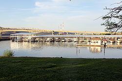
Umatilla (/ˌjuːməˈtɪlə/, YOO-mə-TIL-ə) is a city in Umatilla County, Oregon, United States. It is named for the Umatilla River, which enters the Columbia River on the side of the city. The river is named after the Umatilla Tribe. The city is on the south side of the Columbia River along U.S. Route 730 and I-82.
Contents
Map of Umatilla, OR 97882, USA
The Umatilla Chemical Depot, and the Umatilla Chemical Agent Disposal Facility, is 6 miles (10 km) southwest of the city, northwest of the intersection of I-84 and I-82. The estimated population in 2012 was 7,010.
Umatilla is part of the Pendleton–Hermiston Micropolitan Statistical Area.
History
The first Umatilla post office was established in September 1851 at the Umatilla Indian Agency about 5 miles (8 km) east of Pendleton, and discontinued in January 1852. This was before Timothy K. Davenport surveyed for a town site at the mouth of the Umatilla River in 1862. The site was first known as Umatilla Landing, then Umatilla City, then Columbia, then Umatilla City once again over the next year or so. Its post office was established in 1863 with Z. F. Moody as postmaster.
Umatilla's earliest importance was as a trade and distribution center on the Columbia River, during the gold rush of the 1860s and 1870s in eastern Oregon. It remained a major commercial center until the 1880s when it withered before the Oregon Railway and Navigation Company.
The Umatilla Chemical Depot opened in 1941, to prepare for World War II. The depot's mission was to store and maintain a variety of military items, from blankets to ammunition. The depot took on its chemical weapons storage mission in 1962. From 1990 to 1994 the facility reorganized in preparation for eventual closure, shipping all conventional ammunition and supplies to other installations. On October 25, 2011, the last barrel of HD mustard agent was destroyed and there is no longer a risk of chemical accident in Oregon and Washington.
Geography
Umatilla is 30 miles (48 km) northwest of Pendleton.
According to the United States Census Bureau, the city has a total area of 4.63 square miles (11.99 km2), of which, 4.42 square miles (11.45 km2) is land and 0.21 square miles (0.54 km2) is water.
Climate
According to the Köppen Climate Classification system, Umatilla has a semi-arid climate, abbreviated "BSk" on climate maps.
2010 census
As of the census of 2010, there were 6,906 people, 1,634 households, and 1,215 families residing in the city. The population density was 1,562.4 inhabitants per square mile (603.2/km2). There were 1,766 housing units at an average density of 399.5 per square mile (154.2/km2). The racial makeup of the city was 70.1% White, 2.3% African American, 1.5% Native American, 0.6% Asian, 23.1% from other races, and 2.4% from two or more races. Hispanic or Latino of any race were 43.1% of the population.
There were 1,634 households of which 50.8% had children under the age of 18 living with them, 51.2% were married couples living together, 14.7% had a female householder with no husband present, 8.5% had a male householder with no wife present, and 25.6% were non-families. 18.5% of all households were made up of individuals and 6% had someone living alone who was 65 years of age or older. The average household size was 3.15 and the average family size was 3.59.
The median age in the city was 30.7 years. 26.1% of residents were under the age of 18; 11.7% were between the ages of 18 and 24; 35.6% were from 25 to 44; 20.2% were from 45 to 64; and 6.3% were 65 years of age or older. The gender makeup of the city was 63.7% male and 36.3% female.
2000 census
As of the census of 2000, there were 4,978 people, 1,364 households, and 1,062 families residing in the city. The population density was 1,415.3 people per square mile (546.0/km²). There were 1,511 housing units at an average density of 429.6 per square mile (165.7/km²). The racial makeup of the city was 72.10% White, 2.69% African American, 1.35% Native American, 0.38% Asian, 0.06% Pacific Islander, 21.49% from other races, and 1.93% from two or more races. Hispanic or Latino of any race were 32.58% of the population.
There were 1,364 households out of which 45.7% had children under the age of 18 living with them, 58.2% were married couples living together, 13.0% had a female householder with no husband present, and 22.1% were non-families. 16.9% of all households were made up of individuals and 5.1% had someone living alone who was 65 years of age or older. The average household size was 3.14 and the average family size was 3.51.
In the city, the population was spread out with 31.0% under the age of 18, 12.1% from 18 to 24, 34.7% from 25 to 44, 16.5% from 45 to 64, and 5.7% who were 65 years of age or older. The median age was 29 years. For every 100 females there were 137.8 males. For every 100 females age 18 and over, there were 157.3 males.
The median income for a household in the city was $33,844, and the median income for a family was $32,969. Males had a median income of $28,500 versus $20,337 for females. The per capita income for the city was $11,469. About 15.6% of families and 19.4% of the population were below the poverty line, including 24.2% of those under age 18 and 21.1% of those age 65 or over.
Economy
The local economy is heavily reliant on agriculture and supporting services. As of 2001, the five largest employers in Umatilla were the Two Rivers Correctional Institution, JM Manufacturing (polyvinyl chloride pipes), Gilroy Food (dehydrated onions), Boise Cascade (wood chips), and Oregon Rustic (pine furniture). The Port of Umatilla is also home to Aramark, Hagerman Trucking, Pendleton Grain Growers, Tidewater, WM Moss Jr. Corp., Diamond Line Delivery and Amazon.com. Amazon.com recently started developing a data center campus in Umatilla in support of Amazon Web Services.