
Population 1,151 (2011) Sovereign state United Kingdom Local time Thursday 10:23 PM UK parliament constituency Stroud | OS grid reference ST790984 Dialling code 01453 | |
 | ||
Weather 14°C, Wind S at 14 km/h, 69% Humidity | ||
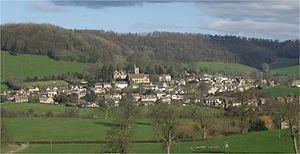
Uley /ˈjuːli/ is a village in the county of Gloucestershire, England. It is situated in a wooded valley in the Cotswold escarpment, on the B4066 road between Dursley and Stroud. The population is around 1,100, but was much greater during the early years of the industrial revolution, when the village was renowned for producing blue cloth. The placename (recorded as Euuelege in the Domesday Book) probably signifies 'clearing in a yew wood'.
Contents
Map of Uley, Dursley, UK
History
The Romans built a temple at West Hill, near Uley, on the site of an earlier prehistoric shrine. Following the laying of a water main pipe there in 1976, many discoveries were made including numerous Roman writing tablets or lead curse tablets from the temple area. These writing tablets appear often to relate to theft, and here the mention of animals and farm implements is a regular theme. There is an ongoing, online project to catalogue all those found at West Hill. Other remains from this temple, including a fine stone head of Mercury, can now be seen in the British Museum. There were significant Roman villas nearby at Frocester, Kingscote, and Woodchester, and there is a little-known Roman villa beneath Cam Peak on the road into Dursley.
St Giles's Church near the village green was designed by the 19th-century architect Samuel Sanders Teulon. His building replaced an earlier church dating back to Norman times, which had in its turn replaced a Saxon church. The nearby church of the Holy Cross at Owlpen also has Saxon origins: the church there was rebuilt in 1828 by Samuel Manning and enlarged and decorated in 1876 by James Piers St Aubyn. There were also non-conformist chapels at South St and Whitecourt until the early 1970s.
The village was once famous for its large number of pubs (around 14), lately reduced to a single hostelry (The Old Crown). Until the 1970s there was also a butcher's shop and a petrol station, these were subsequently replaced by antique shops and occasional restaurants, and now only a small village shop remains.
The area surrounding Whitecourt appears to have some considerable historical significance, with long associations to the Osborne family and a possible Roman road transecting from Kingscote to the East via Bencombe, crossing the Ewelme brook close to the previous mill buildings opposite Stouts hill and then transiting what is now Lampern View before exiting W towards Cam/Coaley; elements clearly visible just uphill of Bencombe (as the road veers 90 degrees to the north) and to the West opposite the entrance to Angeston Grainge/Nursery (where it enters the wood as a paved and walled causeway.
The increased mechanisation of agriculture in the area (arable on top of the escarpment, sheep on it and cattle in the valleys) led to a gradual decline during the inter-war periods and this led to the construction of three local authority housing estates - South Street, Lampern View and Raglan Way. However, increased mobility following the construction of the M4 and the Severn Bridge in the mid-1960s, together with an influx of skilled/managerial/professional workers following the establishment of such facilities as the Berkeley power station, led to a steady gentrification of the village, witnessed by the construction of substantial detached homes, for example at Court Gardens, South Street and Green Close.
Economy
Uley Brewery was established in the 1980s, in a Grade II listed building that had been part of the 1833 Price Brewery which closed at the end of the 19th century. The brewery was purchased and refitted by current owner Chas Wright, complete with custom-made brewing vessels. The brewery is situated above a natural spring, and uses Maris Otter barley malt (sourced from Tuckers Maltings, Newton Abbot), Fuggles and Goldings hops, and a traditional method of top fermentation. Its range of ales includes Old Spot Prize Ale, a 5% abv old ale, and Uley Bitter, a 4% abv cask bitter.
Amenities and surrounding locality
The following amenities and attractions are available in and around the village: