
Width 8.5 km (5.28 mi) Highest elevation 1,142 m (3,747 ft) Area 78 km² | Length 15 km (9.3 mi) Coastline 38 km (23.6 mi) Highest point Blåtinden | |
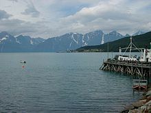 | ||
Uløya (Northern Sami: Ulisuolu) is an island in Skjervøy and Nordreisa municipalities, Troms county, Norway. The island is situated on the east side of the Lyngen fjord. The island has an area of 78 km2 (30 sq mi), and the highest point is Blåtinden at 1,142 m (3,747 ft). The population (2001) on the Skjervøy part of the island is 29, and the population (2001) on the Nordreisa part is 65.
Contents
Map of Ul%C3%B8ya, Norway
Uløya is the 56th largest island in Norway. All of the island of Uløya was originally in Skjervøy municipality, but in 1972 the southern part of the island was transferred to neighboring Nordreisa municipality.
Villages
Villages include Havnnes.
References
Uløya Wikipedia(Text) CC BY-SA