
Postal codes 07407 Local time Thursday 8:08 PM Postal code 07407 | Time zone CET/CEST (UTC+1/+2) Area 122.3 km² Population 6,482 (31 Dec 2008) | |
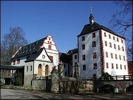 | ||
Elevation 169 - 526 m (−1,557 ft) Weather 16°C, Wind S at 6 km/h, 60% Humidity Points of interest Schloss Kochberg, Saale, Flößerei‑Museum, Burgruine Schauenforst, Luisenturm | ||
Uhlst dt kirchhasel d ortsteil uhlst dt evang kirche vollgel ute
Uhlstädt-Kirchhasel is a municipality in the district Saalfeld-Rudolstadt, in Thuringia, Germany. On 1 December 2007, the former municipalities Großkochberg and Heilingen were incorporated by Uhlstädt-Kirchhasel. The valley of the river Saale is the centre of Uhlstädt-Kirchhasel. Both Uhlstädt and Kirchhasel are villages inside this valley, which divides the municipality into a northern and a southern part. The nearest bigger towns are Rudolstadt(about 7 km away), Saalfeld(about 11 km away) and Jena(about 25 km away).
Contents
- Uhlst dt kirchhasel d ortsteil uhlst dt evang kirche vollgel ute
- Map of 07407 UhlstC3A4dt Kirchhasel Germany
- Uhlst dt kirchhasel d ortsteil wei en evang kirche vollgel ute
- History
- References
Map of 07407 Uhlst%C3%A4dt-Kirchhasel, Germany
The 32 local subdivisions of this municipality are:(inhabitants)
Uhlst dt kirchhasel d ortsteil wei en evang kirche vollgel ute
History
The municipality Uhlstädt-Kirchhasel was founded on 1 July 2002 by a voluntary fusion of the municipalities Beutelsdorf, Dorndorf, Engerda, Kirchhasel, Niederkrossen, Rödelwitz, Schloßkulm, Schmieden, Teichweiden, Uhlstädt and Zeutsch, which were independent before this fusion. On 1 December 2007 the municipalities Großkochberg and Heilingen, which were independent until this point too, become also part of the municipality Uhlstädt-Kirchhasel.