
Area 986,245 km² Established 1997 | ||
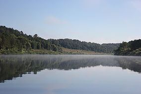 | ||
Ugra National Park (Russian: Национальный парк Угра) is a national park in central Russia, located in Kaluga Oblast, in the valley of the Ugra River. It was established on 10 February 1997 to protect typical landscapes of Central Russia. In 2002, it was designated a UNESCO biosphere reserve. The headquarters of the national park are located in Kaluga.
Contents
Geography
The total area of the park is 986,245 square kilometres (380,791 sq mi). It consists of seven clusters grouped into three areas,
Mammals in the park include moose, wild boar, roe deer, Eurasian beaver, and muskrat. Russian desman is an endangered species which lives in lakes within the park.
Tourism
The rivers in the park are popular for kayaking.
The park is located in a historical area with significant number of cultural attractions which include Optina Monastery and the location of the Great stand on the Ugra river which took place in 1480 between the armies of the Grand Duchy of Moscow and the Golden Horde.