
Existed: 1951 – present Constructed 1951 | Length 103.8 km | |
 | ||
Counties | ||
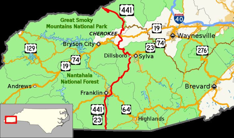
U.S. Route 441 (US 441) is a north–south United States highway that runs for 64.5 miles (103.8 km) from the Georgia state line near Dillard, to the Tennessee state line in the Great Smoky Mountains National Park.
Contents
Route description
Upon crossing the state line from Georgia, US 23/US 441 enter the Nantahala National Forest. The concurrent routes head north through a pair of small communities before intersecting US 64 in Franklin. US 23/US 441 turn east, briefly overlapping US 64 southeast of Franklin before separating from the route and continuing to the northeast through the Cowee Mountains. After passing Dillsboro, US 23/US 441 intersect US 74 (Great Smoky Mountains Expressway); US 23 splits east towards Waynesville, while US 441 joins US 74 westbound towards Bryson City. After traversing 7 miles (11 km) along the northern banks of the Tuckasegee River, US 441 splits from US 74 and continues north into the Qualla Boundary. In Cherokee, US 441 shares a short one-half-mile (0.80 km) concurrency with US 19, then continues north along the west bank of the Oconaluftee. After entering the Great Smoky Mountains National Park, US 441 connects to the southern terminus of the Blue Ridge Parkway. Known officially in the park as Newfound Gap Road, US 441 traverses northwesterly through park until it reaches Newfound Gap at the Tennessee state line.
US 441 within the Great Smoky Mountains National Park is maintained by the National Park Service and no commercial traffic is allowed. During the winter season, the road in the high elevation may be temporary closed due to inclement weather; signs after the park entrance and/or at the Oconaluftee Visitor Center will notify travelers/visitors on any closings or condition changes.
US 441 also makes up part of Corridor A and Corridor K in the Appalachian Development Highway System (ADHS). Corridor A connects Interstate 285 (I-285) in Sandy Springs, Georgia to I-40 near Clyde, North Carolina; it overlaps twenty miles (32 km) of US 441. Corridor K connects I-75 in Cleveland, Tennessee with US 23 in Dillsboro; it overlaps seven miles (11 km) of US 441. ADHS provides additional funds, as authorized by the United States Congress, which have enabled US 441 to benefit from the successive improvements along its routing in both corridors. The white-on-blue banner "Appalachian Highway" is used to mark the ADHS corridor.
History
Established in 1951, US 441 was placed on existing highways through the region: a concurrency with US 23 from the Georgia state line through Franklin to Dillsboro; and a concurrency with NC 107 from Dillsboro through the Qualla Boundary and the Great Smoky Mountains National Park to the Tennessee state line. In 1956, NC 107 was removed from the route. In 1970, the National Park Service requested, and subsequently approved, that US 441 shields be discontinued through the Great Smoky Mountains National Park.
In 1974, US 23/US 441 was placed on new bypass east of Franklin; its old alignment through Franklin became US 441 Business (US 441 Bus.). In Dillsboro, US 441 was placed on new alignment continuing north from Haywood Road onto new interchange with US 19A/US 23; its old alignment along Haywood Road was downgraded to secondary road.
No major changes have been made since the mid-1970s, however modernizing improvements have been made including the construction of additional lanes and full interchanges at major intersections along its route.
Franklin business loop
U.S. Route 441 Business (US 441 Bus), established in 1974, is a 2.7-mile (4.3 km) business route that traverses through downtown Franklin via Porter Street, Palmer Street, and Main Street. A couple of months after its initial establishment, it was adjusted in the downtown area along the one-way streets.
The entire route is in Franklin, Macon County.
Cherokee business loop
U.S. Route 441 Business (US 441 Bus), established in 1988, is a 1.9-mile (3.1 km) business route that traverses through downtown Cherokee via Casino Trail, Paint Town Road, and Tsalagi Road. The business route was established as a new routing through the downtown area; today it provides a direct route to Harrah's Cherokee.