
Counties: Berrien | Length 4.562 km | |
 | ||
Existed: 1937 (1937) – April 25, 1997 (1997-04-25) History: Last signage removed in April 1998 | ||
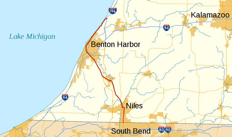
US Highway 33 (US 33) is a part of the United States Numbered Highway System that was once located in Berrien County, Michigan. At the time it was removed from the state, it was only about 2.8 miles (4.5 km) long running north from the Indiana state line to an intersection with US 12 south of Niles. The highway was not originally part of the US Highway System in the state; it was added in 1937 as a second designation for part of US 31 between the state line and St. Joseph. It was later extended further north to the community of Lake Michigan Beach. This extension became the only section of US 33 that was routed independent of another highway until it was truncated to Niles. In 1997, US 33 was officially removed from the state.
Contents
Route description
At the time it last existed in Michigan, US 33 started at the Indiana state line at an intersection with State Line Road. From there it ran due north along 11th Street through a residential neighborhood parallel to the St. Joseph River. Just past an intersection with Fulkerson Road, the highway curved briefly to the northeast as it approached Bell Road. US 33 terminated at a five-ramp partial cloverleaf interchange with US 12 (Pulaski Highway) south of the city of Niles in Bertrand Township. According to the Michigan Department of Transportation (MDOT), the agency that maintained the roadway, in 1998, the last year it was US 33, the highway carried between 17,192 and 24,669 vehicles on average, daily. Additionally, the roadway that carried the highway designation is listed on the National Highway System, a network of roads important to the country's economy, defense, and mobility.
History
The State Trunkline Highway System was created on May 13, 1913, by an act of the Michigan Legislature; at the time, one of the system's divisions corresponded to US 33. Division 5 followed a course from Niles northward to Mackinaw City. In 1919, the Michigan State Highway Department (MSHD) signposted the highway system for the first time, and the future US 33 corridor was assigned the original M-58 designation from the state line northward through Niles to St. Joseph. When the United States Numbered Highway System was created on November 11, 1926, the corridor received the US 31 designation. The US 33 designation was later added to US 31 from the state line northward to St. Joseph in 1937.
In November 1960, the US 33 designation was extended northward along US 31 from St. Joseph through Benton Harbor to Lake Michigan Beach Two years later, a segment of freeway opened east of Benton Harbor, and US 31 was rerouted to follow it, leaving US 33 to its own alignment between Scottdale and Lake Michigan Beach. This was the first time that US 33 had a section of its routing in Michigan that was not concurrent with another highway. Also, the northernmost 1⁄2 mile (0.80 km) of US 33 overlapped part of US 31 between the freeway and its old routing, resulting in a wrong-way concurrency. This concurrency was removed the next year when another freeway section for I-196/US 31 opened north of the previous endpoint, removing US 31 from Hagar Shores Road. Additional freeway for US 31 was built in the late 1970s into the 1980s. Called the St. Joseph Valley Parkway, the first section of this freeway through Berrien County was completed in 1979 and ran from the Indiana state line north to US 12; after its completion, US 33 had a second independent routing from the state line north to US 12 where US 31 merged back in from its new freeway routing.
US 33 was all but eliminated in Michigan on June 9, 1986, when the American Association of State Highway and Transportation Officials (AASHTO) approved a request by MDOT to truncate the designation to the intersection with US 12 south of Niles. A year later, construction of the Niles Bypass was finished, bringing the parkway north to Walton Road northwest of Niles. Signage was updated for US 33 at the same time, and the M-63 designation was assigned to US 33 from Scottdale to Lake Michigan Beach, while the US 31 designation ran solo on the highway between Scottdale and the Niles Bypass. Business US 31 (Bus. US 31) was created along the former routing of US 31/US 33 between the bypass and Niles while the remainder of US 33 through downtown became part of Bus. US 12 or M-51. The last segment of US 33 between US 12 and the state line was removed on April 25, 1997, when AASHTO approved a joint request by MDOT and its counterpart in Indiana to truncate the highway designate to an intersection with US 20 in Elkhart, Indiana. This remaining segment in Michigan became part of an extended M-51 when the signage was changed a year later.
On March 5, 2010, a segment of Bus. US 12 previously used by US 33 in downtown Niles was transferred back to city control. Otherwise, all of US 33 at its greatest extent from 1961 through 1987 remains part of a state highway in Michigan. From the state line into Niles, it is M-51. From the west side of downtown Niles, it is M-139 to Scottdale, and from there north, it is M-63
Major intersections
The entire highway was in Bertrand Township, Berrien County.