
Existed: 1927 – present Constructed 1927 | Length 270.4 km | |
 | ||
Counties Cleveland County, North Carolina | ||
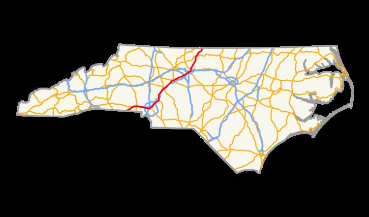
U.S. Route 29 is a north–south United States highway that runs for 168 miles (270 km) from the South Carolina state line, near Blacksburg, to the commonwealth of Virginia, near Danville. The route serves the North Carolina Piedmont, including the cities of Charlotte, Salisbury, High Point, and Greensboro.
Contents
History
Established in 1927, it ran from the South Carolina state line to US 74 in Kings Mountain, with a concurrency with NC 205. In 1929, NC 205 was removed.
US 29's first extension was in 1932, following US 74/NC 20 east into Charlotte; it then replaced US 170 from Charlotte to the Virginia state line. In 1937, it replaced a stretch of NC 7 going between Kings Mountain and Gastonia; the old route briefly became alternates for both U.S. Routes before becoming NC 161 and NC 274.
In 1938, US 29 was moved onto a new bypass around Kannapolis-China Grove, leaving US 29A on the old route. In 1948, the routes were switched. In 1952, US 29 was moved onto new bypasses around Lexington and Thomasville, leaving behind US 29A in both cities. In 1957, US 29 was moved onto its modern route from Thomasville to Jamestown, old route became part of NC 62 and US 70A.
In 1957 or 1958, US 29 was moved onto new bypass west of Reidsville, leaving US 29A (later US 29 Business) through Reidsville. Also around same time, US 29 was moved onto new bypass east of Kings Mountain, extending NC 216 over its old route; then in Charlotte, it moved onto I-85 between Little Rock Road (exit 32) and the University City area (exit 42), old route through Charlotte as US 29 Business. In 1961 or 1962, US 29 was moved back further to NC 273 going onto I-85; but surprisingly, in 1963, US 29 was placed back on its original route through Charlotte again. Similar action also in Salisbury, where in 1960 US 29 was moved onto I-85, then in 1964 or 1965 it was moved back through town.
In 1973, US 29 was placed on a new freeway bypass east of Reidsville; its old bypass route was reverted to US 29 Business, while the old US 29 Business through Reidsville was removed. Between 1980-1982, the freeway from Reidsville was extended into Virginia.
U.S. Route 170
U.S. Route 170 (US 170) was an original US highway, established in 1926. It began at the intersection of Trade and Tryon Street in Charlotte, traversing northeast, in concurrency with NC 15 to Concord, Kannapolis, and Salisbury. Northeast of Salisbury, it was overlapped with NC 10 to Lexington, High Point, and Greensboro; via High Point Road to Lee Street, to Fairground Avenue, to Spring Garden Street, to Aycock Street, to West Market Street, to Greene Street, and finally to Summit Avenue, where it begins its overlap with NC 70 heading northwest to Browns Summit. Heading northeast, it went through Reidsville, Ruffin, and finally Pelham before crossing into Virginia towards Danville and eventually Lynchburg. In 1932, the entire route was renumbered as US 29.