
Existed: 1942 – present SH 106 SH 107 → Length 810.9 km | SH 230 SH 231 → Constructed 1942 | |
 | ||
South end: US 69 / US 96 / SH 87 in Port Arthur | ||
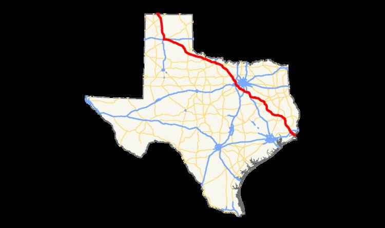
U.S. Highway 287 (US 287) in the U.S. state of Texas is a U.S. Highway that begins on the Gulf Coast in Port Arthur and heads north through Fort Worth, northwest to Childress, Clarendon, and Amarillo in the Texas Panhandle and into Oklahoma near Kerrick.
Contents
Route description
US 287 crosses into Texas at Kerrick and continues southeast through to Stratford, where it takes a more southerly turn. In Dumas, US 287 merges with its "parent route", US 87, and continues its south/southeasterly path as a co-signed route to Amarillo.
After passing through the heart of downtown Amarillo, US 87 splits off to the south to merge with I-27, and US 287 merges with I-40 and continues co-signed with the interstate until just west of Rick Husband Amarillo International Airport, where it veers to the southeast toward Claude, the seat of Armstrong County.
US 287 follows this east-southeasterly path through Clarendon and Childress, where it intersects US Highways 83 and 62. US 287 then proceeds to Vernon, where it merges with (and is briefly co-signed with) US 70 and US 183. After US 70 and US 183 leave the route at Oklaunion and veer to the northeast, US 287 resumes its east-southeasterly track passing through Harrold and Electra on its way to Wichita Falls. On the northwest side of the city US 287 merges with I-44, US 82, and (briefly) US 277. After leaving Wichita Falls, US 82/287 continues as a co-signed route until Henrietta, where US 82 leaves the route. After merging with US 81 in Bowie, US 287/81 continues southeast to Fort Worth, where it merges with I-35W on the north side of town. Just northwest of this interchange, Business US 287 veers off to the right following the original routing into Saginaw and into downtown Fort Worth while zig zagging its way through city streets to Kennedale and Mansfield before coming out onto the US 287 Freeway south of Interstate 20 near the Ellis County line just north of Midlothian.
Here, US 81 hits its terminus, but US 287 continues, concurrent route with I-35W through to the north end of downtown Fort Worth before splitting off to the southeast and once again picking up its own signage. This stretch of US 287, which runs from downtown to the southeast side of the city, is also known as the Martin Luther King, Jr. Freeway. In southeast Fort Worth, US 287 intersects with, and is briefly co-signed with, I-820 (which then dumps into I-20) before veering to the southeast yet again, where it passes through the extreme western side of Arlington, and then on in to Mansfield and Midlothian The freeway which previously terminated at the Tarrant/Johnson County line has been extended continuing on into Ellis County to connect with the existing freeway around Waxahachie, which includes a bypass around Midlothian and an interchange with US 67.
After intersecting with I-35E just north of Waxahachie, US 287 continues to the southeast, where it merges with I-45 just south of Ennis and follows the interstate to Corsicana where it then leaves the route and makes another sharp turn to the east. The highway continues southeastward to Palestine, where it merges with State Highway 19. US 287/SH 19 continues as a co-signed route until Crockett, where US 287 leaves SH 19 and continues its southeasterly track toward the Texas Gulf Coast.
In Woodville, US 287 merges with US 69 and takes on a more due-southerly route to Lumberton, where a co-signed US 69/287 also merges with US 96. The highway then continues to the southeast through Beaumont with a short stint with Interstate 10 and on to Port Arthur, where the route terminates at an intersection with State Highway 87.
History
Before 1939, the portion from the Oklahoma state line to Amarillo was SH 9, from Amarillo to Henrietta was SH 5, Henrietta to Bowie was SH 50, Bowie to Fort Worth was SH 2 and US 81, Fort Worth to Ennis SH 34, Ennis to Corsicana was SH 14/US 75, Corsicana to Palestine was SH 22, Palestine to Crockett was SH 19, Crockett and Woodville was SH 106, Woodville to Port Arthur was SH 8. All of these state highways were shortened in the 1939 renumbering. SH 106 was decommissioned. SH 19 was deleted until 1960, when it extended back south.