Surface area 3.74 km (1.44 sq mi) Surface elevation 43 m Shore length 14.62 km | Max. width 800 metres (0.50 mi) References NVE Area 3.74 km² | |
 | ||
Max. length 6.5 kilometres (4.0 mi) Reference Norwegian Water Resources and Energy Directorate | ||
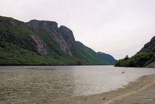
Tysdalsvatnet or Tyssdalsvatnet is a lake in the municipalities of Hjelmeland and Strand in Rogaland county, Norway. The 3.74-square-kilometre (1.44 sq mi) lake lies about 5 kilometres (3.1 mi) south of the village of Årdal and about 8 kilometres (5.0 mi) east of the village of Tau. The Norwegian National Road 13 (Rv13) runs along the northern side of the lake. The Svo Tunnel was completed in 2013 and it routes much of Rv13 through a mountain rather than along the narrow shoreline of the lake.
Map of Tysdalsvatnet, Norway
References
Tysdalsvatnet Wikipedia(Text) CC BY-SA
