
Area rank 95 in Norway Area 1,089 km² Local time Monday 2:17 AM | Administrative centre Hjelmelandsvågen Demonym(s) Hjelmelandsbu Population 2,785 (2015) Administrative center Hjelmelandsvågen | |
 | ||
Weather 2°C, Wind SE at 19 km/h, 69% Humidity | ||
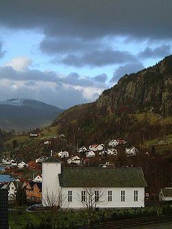
Hjelmeland is a municipality in Rogaland county, Norway. It is located in the traditional district of Ryfylke. The administrative centre of the municipality is the village of Hjelmelandsvågen. Other villages in the municipality include Fister, Årdal, and Jøsenfjorden.
Contents
- Map of 4130 Hjelmeland Norway
- General information
- Name
- Coat of arms
- Churches
- Government
- Municipal council
- Geography
- References
Map of 4130 Hjelmeland, Norway
Hjelmeland is known for its fruit (apples, pears, plums, cherries and strawberries) and fish production. Salmon has been important for the fish industry in Hjelmeland for a couple of decades, but white fish such as cod and halibut has increased its value in the latter years.
General information
Hjelmeland was established as a municipality on 1 January 1838 (see formannskapsdistrikt). In 1859, Hjelmeland municipality was split into two: the southern portion of the municipality (population: 1,315) was split off to form the new municipality of Årdal and the remainder of the municipality became the municipality of Hjelmeland og Fister (population: 3,084). On 1 July 1884, the western islands and the western coast of the mainland (population: 832) were split off from Hjelmeland og Fister to form the new municipality of Fister and the rest of the municipality was renamed simply "Hjelmeland" which now had 2,249 residents.
On 1 January 1965, there were many big municipal mergers across Norway as a result of the Schei Committee. All of Hjelemland municipality (population: 1,691) was merged with most of the municipality of Årdal (except the Sundgardene area along the Årdalsfjorden), the mainland part and the island of Randøy from the municipality of Fister, and the small Buergårdene area on Ombo from the municipality of Jelsa. The population of the newly enlarged Hjelemland was 2,909; nearly doubling the size of the municipal population.
Name
The municipality (originally the parish) is named after the old Hjelmeland farm (Old Norse: Hjalmaland), since the first Hjelmeland Church was built there. Today the farm is a part of the Hjelmelandsvågen urban area. The first element of the name is the plural genitive case of hjalmr which means "helmet" and this is referring to two heights behind the farm which have the form of two helmets. The last element is land which means "land" or "farm".
Coat-of-arms
The coat-of-arms is from modern times; they were granted on 30 November 1984. The arms show a six yellow woven straws on a red background. They are based on the local tradition of making chairs and other furniture with seats of woven twigs (jærstoler). The process of weaving is symbolised in the arms. At the same time the arms show the strength and solidarity of the municipality.
Churches
The Church of Norway has three parishes (sokn) within the municipality of Hjelmeland. It is part of the Ryfylke deanery in the Diocese of Stavanger.
Government
All municipalities in Norway, including Hjelmeland, are responsible for primary education (through 10th grade), outpatient health services, senior citizen services, unemployment and other social services, zoning, economic development, and municipal roads. The municipality is governed by a municipal council of elected representatives, which in turn elect a mayor.
Municipal council
The municipal council (Kommunestyre) of Hjelmeland is made up of 19 representatives that are elected to every four years. For 2011–2015, the party breakdown is as follows:
Geography
The municipality stretches from the mountains bordering the Setesdal valley to the shores of the fjords that connect to the main Boknafjorden. The small Jøsenfjorden and Årdalsfjorden cut into the mainland. There are several islands that are part of Hjelmeland including Randøy and part of Ombo as well as some smaller surrounding islands. The island of Randøy is connected to the mainland by the Randøy Bridge.
There are several large lakes in the municipality including Nilsebuvatnet, Øvre Tysdalsvatnet, and Tysdalsvatnet. The large lake Blåsjø partially lies in the municipality. The Trollgarden glacial moraine lies atop a mountain in Hjelmeland. The Ritland crater is also located in the municipality.