
Fatalities 35 total | ||
 | ||
Formed September 16, 2013 (September 16, 2013) Dissipated September 24, 2013 (September 24, 2013) Highest winds 10-minute sustained: 205 km/h (125 mph)1-minute sustained: 250 km/h (155 mph) Lowest pressure 910 hPa (mbar); 26.87 inHg Damage $4.33 billion (2013 USD) Date 16 September 2013 – 24 September 2013 Similar Typhoon Utor, Typhoon Fitow, Typhoon Soulik, Tropical Storm Trami, Typhoon Wutip | ||
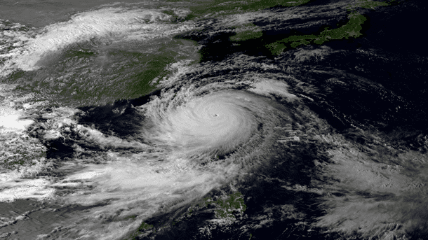
Typhoon Usagi, known in the Philippines as Typhoon Odette, was a violent tropical cyclone which affected Taiwan, the Philippines, China, and Hong Kong in September 2013. Usagi (ウサギ, usagi), which means the constellation Lepus or literally rabbit in Japanese, was the fourth typhoon and the nineteenth tropical storm in the basin. Developing into a tropical storm east of the Philippines late on September 16, Usagi began explosive intensification on September 19 and ultimately became a violent and large typhoon. Afterwards, the system weakened slowly, crossed the Bashi Channel on September 21, and made landfall over Guangdong, China on September 22.
Contents
Meteorological history
Early on September 16, 2013 the Japan Meteorological Agency (JMA) started to monitor a tropical depression, that had developed within an area of low-moderate vertical windshear about 1,300 km (810 mi) to the east of Manilla in the Philippines. During that day as the systems low level circulation centre became better defined, the Joint Typhoon Warning Center (JTWC) issued a Tropical Cyclone Formation Alert on the system while the Philippine Atmospheric, Geophysical and Astronomical Services Administration (PAGASA) named the system Odette.
Late on the same day, JMA upgraded the system to a tropical storm and named it Usagi; at the same time, The JTWC upgraded it to a tropical depression 17W, owing to a tropical upper tropospheric trough cell located to the east in association with an anticyclone enhancing the outflow in the eastern and southern quadrants.
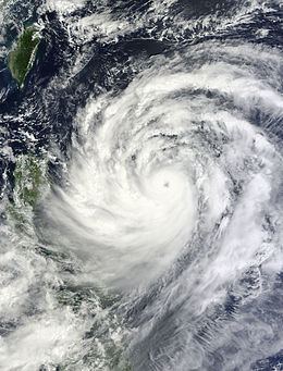
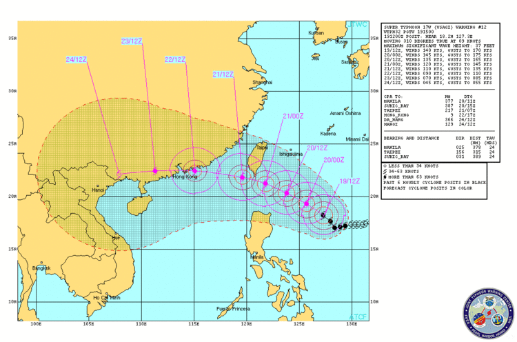
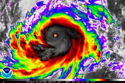
On September 17, The JTWC upgraded Usagi to a tropical storm, as the system continued to consolidate and wrap tighter when slowly tracking westward along the extreme southern periphery of the subtropical ridge. Early on September 18, JMA upgraded Usagi to a severe tropical storm; at noon, both JMA and The JTWC upgraded Usagi to a typhoon, as deep convection had completely wrapped around a developing eye with radial outflow and low vertical wind shear. On September 19, Usagi began explosive intensification and formed a 28 km (17 mi) round eye; as the result, The JTWC upgraded Usagi to a category 5 equivalent-super typhoon on the Saffir–Simpson hurricane wind scale at noon. However, in a post season reanalysis, it was concluded that Usagi peaked with winds at 155 mph, making it a strong category four on the Saffir-Simpson hurricane wind scale. At 18Z, Usagi reached its peak intensity with 10-minute maximum sustained winds at 205 km/h (125 mph) and the atmospheric pressure at 910 hPa (26.87 inHg) On September 20, Usagi began an eyewall replacement cycle with a 75 km (47 mi) inner eyewall and a 190 km (120 mi) outer eyewall separated by a clearly defined moat, as well as the system began to weaken late on the same day due to land interaction between Taiwan and Luzon.
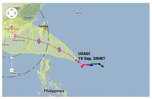
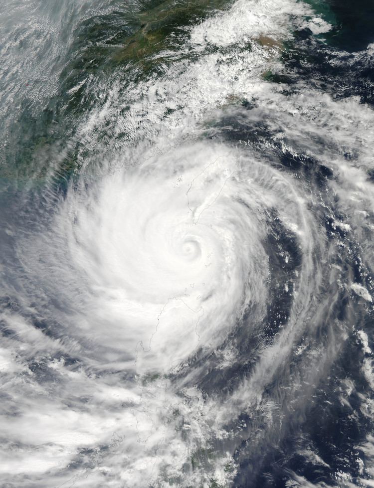
When Usagi had ventured into the Bashi Channel early on September 21, the JTWC downgraded it to a typhoon for convection becoming more shallow. However, sustained winds up to 180 km/h (110 mph) and the atmospheric pressure at 923 hPa (27.26 inHg) were recorded on Basco, Batanes when the eyewall passed the municipality. Later on, PAGASA recorded peak gust of 85 m/s (306 kph) at Basco. Later, as the eyewall replacement cycle had completed, the eye became cloud-filled, although the environment remained favourable with excellent radial outflow and low vertical wind shear. On September 22, Usagi’s eye resurged, allowing the typhoon maintaining intensity when approaching the coast of China. At 11:40 UTC (19:40 CST), Typhoon Usagi made landfall over Shanwei, Guangdong, China with 10-minute maximum sustained winds at 85 knots (155 km/h, 100 mph) and the atmospheric pressure at 935 hPa (27.61 inHg). Soon, the JTWC issued its final warning on Usagi, while the JMA downgraded it to a severe tropical storm at 18Z. On September 23, the JMA downgraded the Usagi to a tropical storm and later a tropical depression in Guangxi. The system subsequently dissipated during September 24.
Preparations and impact
At least two people, a 50-year-old man and a 20-year-old woman, drowned when a passenger boat capsized off northeastern Aurora province in the Philippines, and two others were missing. Cathay Pacific Airways and Dragonair said flights on September 21 were unaffected, but for one canceled flight. However, both airlines announced that flights to and from Hong Kong International Airport would be cancelled starting 6 p.m. September 22 and resume the next day if conditions allow. In Taiwan, more than 3,000 people were evacuated from flood-prone areas and mountainous regions. Some mountain roads were blocked by landslides, and power outages suspended some train service.
In response to the storm’s approach Hong Kong, the Hong Kong Observatory issued the No. 8 Gale or Storm Signal at 6:40PM local time on 22 September. It made landfall near Shanwei of the Chinese Guangdong province, and passed to the north of Shenzhen, heading northeast. As the typhoon moved away from Hong Kong, the HKO lowered the typhoon signal to the Strong Wind Signal No. 3 at 9:20AM on 23 September. Usagi dissipated on September 24.
Throughout Guangdong, China, at least 15,000 homes were destroyed and 152,000 hectares of crops were lost. Total economic losses in the province reached ¥17.76 billion (US$2.9 billion). At least 50 people have died in Asia; of this number, 30 deaths occurred in Guangdong province of south China.
Philippines
Early on September 17, PAGASA issued the public storm warning signal number 1 for Cagayan, Calayan and the Babuyan island groups, however these were lifted later that day as Usagi was expected to remain almost stationary for 24 – 36 hours. PAGASA subsequently reissued warning signal number 1 for Cagayan, Calayan, Isabela and the Babuyan island group, during the next day after the system became a typhoon and started moving again. Early the next day as the system intensified further Signal 1 and 2 were hoisted for 7 and 5 areas respectively. Later that day as Usagi approached Northern Luzon and the JTWC reported that the system had become a super typhoon signal 4 was raised for the Batanes island group while signal 3 was hoisted for the Calayan and Babuyan Island groups and various other areas were placed under signals 1 and 2.
China
Within China a total of 35 people were killed, while 15 rivers within Fujian, Guangdong, Hainan and Jiangxi were flooded between September 23–25. Within Guangdong and Fujian province, heavy to heavy rain was recorded, with the Liangshan mountain in Fujian Province recording 407 mm (16.0 in) of rain, while 308 mm (12.1 in) of rain was measured in the Gaojiping, Guangdong Province.
Hong Kong
As Usagi neared to Hong Kong, news and media began rapidly reporting on "the strongest storm in 34 years" that would hit Hong Kong. However, in the afternoon of 22 September, Usagi's course veered northwest, and Hong Kong was subsequently spared from the impact of Usagi's eye wall, only being covered by Usagi's storm area. Usagi made landfall at 130 kilometers (80 miles) to the east-northeast, and continued further northward that expected. Even though Usagi caused a direct hit as it skirted at 80 km north of the Hong Kong Observatory Headquarters, the city faced only faced the strongest storm of the year, with northwest gales affecting many places including Victoria Harbour, Airport, Lau Fau Shan and Tai Mei Tuk, as well as occasional storm-force winds that were limited to Cheung Chau and some offshore areas. Hurricane was recorded only on high grounds like Ngong Ping and Tai Mo Shan. West to southwest gales took place later on as Usagi passed through Shenzhen. The most recent tropical cyclone that necessitated the issuance of Hurricane Signal No. 10 -- Typhoon Vicente from the previous year, was still more damaging in Hong Kong. Nevertheless, Usagi caused 17 injuries and prompted the Hong Kong Observatory to issue the No. 8 Gale or Storm Wind signal, keeping it in force for almost 15 hours.
Macau
The damage in Macau was less than that in Hong Kong because Usagi veered northwest before impact, putting Macau at the edge of Usagi's gale area, thus having weaker winds. The Macao Meteorological and Geophysical Bureau originally stated to consider hoisting the Signal No.8 before 7:00PM local time (UTC+8) on 22 September, but the sudden change of Usagi's track ruled out the possibility of hoisting higher signals. Usagi only required the Bureau to hoist the Signal No. 3, as the wind speed recorded in Macau reached the level of strong wind only. Usagi's closest point of approach to Macau is 100 km to the north-northeast, at 4:00AM on 23 September, which means that it was barely a direct hit.
Replacement
The name Odette, Usagi's local name, was used for the first time, due to the significant amounts of fatalities Ketsana's local name Ondoy caused in September 2009. When the said season ended, PAGASA announced that the name Ondoy would be retired and was replaced by Odette in June 2012.