Formed October 13, 2016 Fatalities 34 | Dissipated October 19, 2016 | |
 | ||
Highest winds 10-minute sustained: 175 km/h (110 mph)1-minute sustained: 215 km/h (130 mph) Lowest pressure 935 hPa (mbar); 27.61 inHg Damage $756.7 million (2016 USD) Date 13 October 2016 – 19 October 2016 Similar Typhoon Sally, Typhoon Haima, Typhoon Meranti, Tropical Storm Nida, Typhoon Aere | ||
Typhoon sarika karen strikes luzon and typhoon haima is next philippines
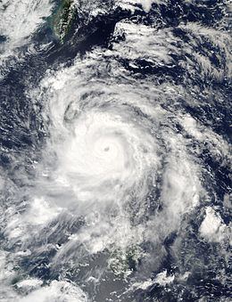
Typhoon Sarika, known in the Philippines as Typhoon Karen, was a powerful tropical cyclone which affected the Philippines, China and Vietnam in mid October 2016. It was the twenty first named storm and the tenth typhoon of the annual Pacific typhoon season.
Contents
- Typhoon sarika karen strikes luzon and typhoon haima is next philippines
- Typhoon sarika karen 24w 2016
- Meteorological history
- Philippines
- China
- Retirement
- References
Typhoon sarika karen 24w 2016
Meteorological history
Sarika was first noted by the United States Joint Typhoon Warning Center as a tropical disturbance during October 11, while it was located about 1,050 km (650 mi) to the southeast of Manilla in the Philippines. At the time deep atmospheric convection was moving and expanding, over the system's elongated and ill-defined low level circulation centre. During that day the system's low level circulation centre rapidly consolidated and became more defined within a favourable environment for further development, which consisted of low vertical wind shear and warm sea surface temperatures of about 30 °C (86 °F). As a result of this the Japan Meteorological Agency started to monitor the system as a tropical depression, while the JTWC issued a tropical cyclone formation alert on the depression. During October 12, as the system moved along a low to mid level reflection of the subtropical ridge of high pressure, it was classified as Tropical Depression 24W by the JTWC, while PAGASA named the system Karen.
On October 12, the JMA upgraded the tropical depression to a tropical storm and assigned it the international name Sarika. On October 15, Sarika rapidly developed while located in the Philippine Sea, reaching typhoon status. Rapid deepening continued, and the storm intensified from a tropical storm to a Category 4 typhoon in less than 48 hours. After making landfall, most of the convection in the circulation dissipated, and Sarika rapidly weakened back to a minimal typhoon, less than 12 hours after reaching Category 4 intensity.
By October 13, images depicted its LLCC and described it as "broad", and Karen was located in an area of high sea surface temperatures of 31 °C (88 °F). Hours later, both agencies upgraded Karen to a tropical storm, with the JMA naming it as Sarika. Despite the system has maintained its intensity at that time, deep convection had increased and formative banding started to wrap into its center. Sarika was upgraded into a severe tropical storm by the JMA three hours later. Several hours later, Sarika started to form an eye feature, and the JMA upgraded Sarika to a typhoon. After imagery had depicted a significant organisation of convection around the system, the JTWC upgraded Sarika to a Category 1 typhoon. By October 15, the JTWC stated that Sarika had expanded and deepened with a 15 nmi (28 km; 17 mi) wide ragged eye present, and upgraded it into a Category 2 typhoon. Within their next advisory, it was reported that Sarika had strengthened into a Category 3 typhoon. Sarika reached its peak intensity as a Category 4 typhoon with 1-minute sustained winds of 215 km/h (130 mph) and a minimum barometric pressure of 935 mbar. Early on October 16, PAGASA had stated that Sarika had made landfall over in Baler, Aurora. Dramatic weakening occurred as Sarika traversed the islands, by the time the storm entered the South China Sea. After moving westward rapidly for two days, Sarika weakened to a severe tropical storm as it made landfall over in Hainan. By October 19, imagery depicted that Sarika was rapidly deteriorating as it made its final landfall over in the coastline and border of Vietnam and China, while the JTWC issued its final advisory. The JMA followed suit three hours later and dissipated in the same day.
Philippines
Before the typhoon made its landfall in the Philippines, several domestic flights were cancelled and several farm crops were harvested upon the threat of the typhoon in Camarines Sur. On October 15, signal number 3 was raised throughout the area of Catanduanes. NDRRMC recorded damages up to ₱3.86 billion (US$80.4 million).
China
The Hong Kong Observatory issued Strong Wind Signal No. 3. Hainan's capital Haikou received strong winds, almost no flooding, and little damage. Some crops in the northeast part of Hainan were damaged, particularly banana, cassava, and papaya. Total damages from both agricultural and financial losses were reported over in Hainan province at ¥4.56 billion (US$676.3 million).
Retirement
On October 26, PAGASA has announced that the name Karen will be removed from their naming lists because it had caused over ₱1 billion in damages. On January 17, 2017, PAGASA chose the name Kristine to replace Karen for the 2020 season. During the 49th annual session of the ESCAP/WMO Typhoon Committee during 2017, they announced that the name Sarika will be removed from the naming lists. A replacement name will be chosen in February 2018.
