
Formed 20 October 2010 Fatalities None reported Highest wind speed 213 km/h | Dissipated 1 November 2010 Areas affected Japan Affected area Japan | |
 | ||
Highest winds 10-minute sustained: 175 km/h (110 mph)1-minute sustained: 215 km/h (130 mph) Lowest pressure 930 hPa (mbar); 27.46 inHg Date 20 October 2010 – 1 November 2010 Similar Tropical Storm Aere, Typhoon Chataan, Tropical Storm Jangmi, Typhoon Babs, Typhoon Betty | ||
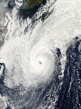
Typhoon Chaba, known in the Philippines as Typhoon Katring, was the first typhoon to impact Japan since Typhoon Melor in October 2009. Chaba means Hibiscus in Thai.
Contents
Meteorological history
Early on 20 October, the Japan Meteorological Agency (JMA) upgraded an area of low pressure into a tropical depression. Later that day, the JMA reported that the tropical depression slightly intensified. The next day, the Joint Typhoon Warning Center started monitoring the system as tropical depression 16W. On 23 October, the system entered the Philippine Area of responsibility and the Philippine Atmospheric, Geophysical and Astronomical Services Administration (PAGASA) started monitoring the system as Tropical Depression "Katring" On 24 October, the JMA and JTWC upgraded the tropical depression into a tropical storm and the JMA named it "Chaba". On 25 October, the JMA further upgraded the storm into a Severe Tropical Storm. Later that day, the JTWC upgraded the storm into a Category 1 Typhoon. Early on 26 October, the JMA further upgraded the storm into a Typhoon. Early on 27 October, the JTWC upgraded the typhoon into a Category 2 Typhoon. Later that day, the JTWC further upgraded the typhoon into a Category 3 Typhoon. The following day JTWC upgraded the system into a Category 4 Typhon. Later that day, the JTWC downgraded Chaba into a Category 3 Typhoon. Early on 29 October, the JTWC further downgraded Chaba into a Category 2 Typhoon, while the JTWC downgraded it into a Category 1 Typhoon. Early on 30 October, the JTWC reported that Chaba had transitioned into an extratropical cyclone. During the afternoon of 30 October, the JMA downgraded Chaba to a remnant low as passed near Japan. The remnants of Chaba continued to weaken as it moved northeast, but strengthened again in approaching the Gulf of Alaska into a major storm with 55-knot winds, kicking up 40–50 foot waves, with pressure as low as 939 mb. The storm's center came ashore in the vicinity of Cordova, Alaska on 1 November, but not before pulling an atmospheric river of moisture into the American Pacific Northwest, setting a record for that date of precipitation in Seattle.
Preparations and impact
In preparation for Chaba, more than 160 flights were cancelled. Islanders in southern Japan started sandbagging doors and reinforcing windows as Chaba churned closer. Strong winds and heavy rains lashed through Okinawa and there were a lot of concerns about the island of Amami which was in the typhoon's path. Over 257 residents were evacuated from the Amami Islands to higher grounds, schools and town halls which were converted into evacuation centers. Late on 29 October, Chaba approached Amami island region in Kagoshima. Strong winds injured five people and felled electric poles cutting electricity supply. Landfall was predicted on the main island of Honshu.
On Minami-Daito Island in Okinawa Prefecture, winds from the typhoon gusted up to 160 km/h (99 mph), resulting in roughly 500 residences losing power. Five people were also injured across the island. Chaba dumped nearly 50 mm (2.0 in) of rain per hour across southern Japan. The Japan Racing Association postponed races in Tokyo until 1 November because of the typhoon.
Retirement
The name Katring was subsequently retired after the usage of this name and eventually replaced with the name Kanor, later changed to Karding.