
 | ||
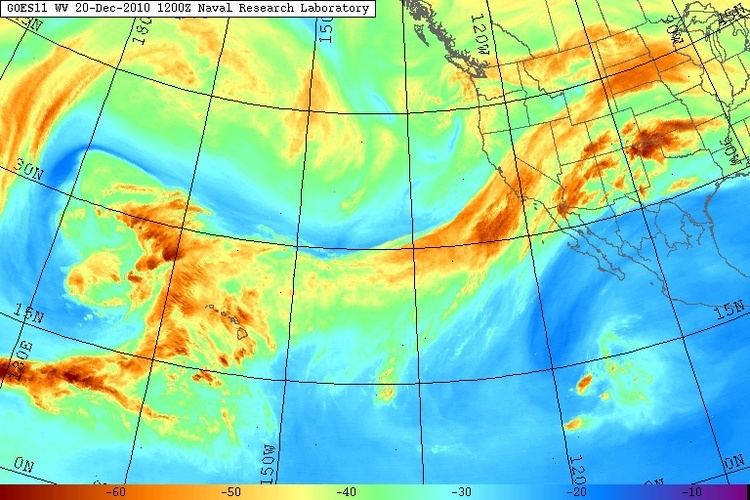
An atmospheric river is a narrow corridor or filament of concentrated moisture in the atmosphere. Atmospheric rivers consist of narrow bands of enhanced water vapor transport, typically along the boundaries between large areas of divergent surface air flow, including some frontal zones in association with extratropical cyclones that form over the oceans. Pineapple Express storms are the most commonly represented and recognized type of atmospheric rivers; they are given the name due to the warm water vapor plumes originating over the Hawaiian tropics that follow a path towards California.
The term was originally coined by researchers Reginald Newell and Yong Zhu of the Massachusetts Institute of Technology in the early 1990s, to reflect the narrowness of the moisture plumes involved. Atmospheric rivers are typically several thousand kilometers long and only a few hundred kilometers wide, and a single one can carry a greater flux of water than the Earth's largest river, the Amazon River. There are typically 3–5 of these narrow plumes present within a hemisphere at any given time. In the current research field of atmospheric rivers the length and width factors described above in conjunction with an integrated water vapor depth greater than 2.0 cm are used as standards to categorize atmospheric river events. However, as data modeling techniques progress, integrated water vapor transport (IVT) is becoming a more common data type used to interpret atmospheric rivers. Its strength lies in its ability to show the transportation of water vapor over multiple time steps instead of a stagnant measurement of water vapor depth in a specific air column (IWV). In addition IVT is more directly attributed to orographic precipitation, a key factor in the production of intense rainfall and subsequent flooding.
Atmospheric rivers have a central role in the global water cycle. On any given day, atmospheric rivers account for over 90% of the global meridional (north-south) water vapor transport, yet they cover less than 10% of the Earth's circumference.
They also are the major cause of extreme precipitation events that cause severe flooding in many mid-latitude, westerly coastal regions of the world, including the West Coast of North America, Western Europe, and the west coast of North Africa.
The significance atmospheric rivers have for the control of coastal water budgets juxtaposed against their creation of detrimental floods can be constructed and studied by looking at California and the surrounding coastal region of the western United States. In this region atmospheric rivers have contributed 30-50% of total annual rainfall. In conjunction Californian land falling Atmospheric Rivers have been historically associated with approximately all major flooding events. The inconsistency of California's rainfall is due to the variability in strength and quantity of these storms, which can produce strenuous effects on California's water budget. The factors described above make California a perfect case study to show the importance of proper water management and prediction of these storms.