
Location Oppland Surface elevation 1,083 m Volume 0.313 km³ | Surface area 33.02 km (12.75 sq mi) Area 33.02 km² | |
 | ||
Water volume 0.313 km (254,000 acre·ft) | ||
Fv 53 norway driving along lake tyin
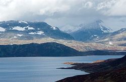
Tyin is a lake in the southwest part of the Jotunheimen mountain range in Norway. The lake lies in Vang municipality in Oppland county, although a small portion extends into Årdal municipality in Sogn og Fjordane county. The western border follows, for a large part, the border between Vang and Årdal. In area it is 33.02 km². The lake serves as a reservoir for Tyin kraftverk and the water level is regulated between 1082.84 and 1072.50 m above sea level. The volume is 0.313 km³.
Contents
Map of Tyin, Norway
Along the south side of the lake goes the national highway, riksvei 53, (Tyin–Årdal) and along the east side goes riksvei 252 (Tyin–Eidsbugarden). The riksvei 252 is accessible from European route E16 via a 3 km link.
In 1869 the Norwegian Mountain Touring Association (DNT) built its first hut, which was located on the shores of Lake Tyin. Today the DNT’s tourist huts make this area, just to the south of Jotunheim National Park, one of the best developed touring areas in Europe. There are also a restricted number of private cabins by the lake.
The name
The name of the lake is derived from the name of the river Tya - the river that connects the lake to Årdalsvatnet and the Sognefjord. The meaning of the rivername is unknown.