
Built 1934 Area 58 ha | NRHP Reference # 95000763 Opened 1934 Added to NRHP 23 June 1995 | |
 | ||
Similar Pleasant Creek Wildlife M, Andrews Methodist Church, Grafton National Cemetery, Valley Falls State Park, Opekiska Lock and Dam | ||
Exploring wv tygart dam and lake
Tygart Dam — also known as Tygart River Dam — is a dam near Grafton in Taylor County, West Virginia, USA. It regulates the waters of the Tygart Valley River. Its storage reservoir is known as Tygart Lake. Most of the lakeshore is occupied by Tygart Lake State Park and Pleasant Creek Wildlife Management Area.
Contents
- Exploring wv tygart dam and lake
- Map of Tygart Dam 530 Paul E Malone Rd Grafton WV 26354 USA
- The damEdit
- The lakeEdit
- References
Map of Tygart Dam, 530 Paul E. Malone Rd, Grafton, WV 26354, USA
The damEdit
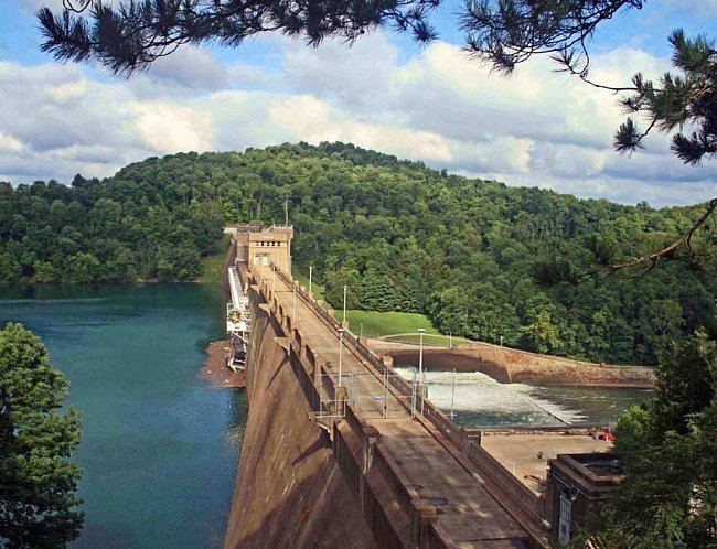
Tygart Dam was designed in part by architect Paul Philippe Cret and built between 1934 and 1938, as a project sponsored by the Public Works Administration to provide for flood control. It is owned and operated by the United States Army Corps of Engineers. The concrete gravity dam has an uncontrolled spillway and measures 1,921 feet long and 209 feet thick at the base. The structure features some Art Deco style decorative elements. Located within the historic area are the Tygart Dam; two damtender dwellings; two maintenance buildings; comfort, storage and concession building; overlook and parking area; and resource manager's office.
It was listed on the National Register of Historic Places in 1995.
The lakeEdit
The southern end of the reservoir reaches into northern Barbour County.