
Car plates PTU | Area 929.4 km² | |
 | ||
Gminas Total 9 (incl. 1 urban)TurekGmina BrudzewGmina DobraGmina KawęczynGmina MalanówGmina PrzykonaGmina TuliszkówGmina TurekGmina Władysławów Voivodeship | ||
Turek County (Polish: powiat turecki) is a unit of territorial administration and local government (powiat) in Greater Poland Voivodeship, west-central Poland. It came into being on January 1, 1999, as a result of the Polish local government reforms passed in 1998. Its administrative seat and largest town is Turek, which lies 117 kilometres (73 mi) east of the regional capital Poznań. The county also contains the towns of Tuliszków, lying 16 km (10 mi) north-west of Turek, and Dobra, 15 km (9 mi) south-east of Turek.
Contents
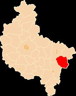
Map of Turek County, Poland
The county covers an area of 929.4 square kilometres (358.8 sq mi). As of 2006 its total population is 83,635, out of which the population of Turek is 29,302, that of Tuliszków is 3,393, that of Dobra is 1,511, and the rural population is 49,429.
Neighbouring counties
Turek County is bordered by Koło County to the north, Poddębice County to the east, Sieradz County to the south, Kalisz County to the south-west and Konin County to the north-west.
Administrative division
The county is subdivided into nine gminas (one urban, two urban-rural and six rural). These are listed in the following table, in descending order of population.