
Founded by ? Demonym(s) tupungatense Area 2,485 km² | Established November 8, 1858 Seat Tupungato Postal Code M5561 Area code 02622 | |
 | ||
Points of interest Domaine Bousquet, Bodega la Azul, Bodega Atamisque, Andeluna Cellars, Cristo rey del valle de Tupungato | ||
Tupungato is a department located in the province of Mendoza, Argentina. The cabecera (departmental capital) 0f Tupungato is located approximately 70 km south of Mendoza city, in the Valle de Uco.
Contents
Map of Tupungato Department, Mendoza Province, Argentina
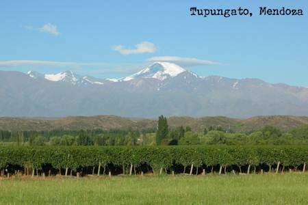
Its name comes from the Tupungato volcano (with 6.570 metres, one of Argentina's highest peaks) with towers over the city from the Andes mountain rig. The volcano's name, in turn, is said to mean "star viewpoint" in the huarpe tongue.
The department is approximately 1.200 metres above mean sea level, and comprises 2.485 km² (1.6% of the provincial total). According to the 2001 census [INDEC], the total population of the department was 28.539 with a density of 11.48 inhabitants per km².
The region is mainly dependent on agricultural production, with vineyards being its most important produce, representing 30% of the planted lands. Other regional products are fruit (mainly peach) and garlic. The wine industry, however, is particularly relevant due to the constant investments and intensive labour occupation. Recent developments in the Argentine economy have further fuelled the Argentine wine industry, attracting foreign investors and tourists to the region in an unprecedented scale.