
Listing Ultra Volcanic arc/belt South Volcanic Zone Last eruption 1987 | Parent range Andes Mountain type Stratovolcano Elevation 6,570 m Prominence 2,765 m | |
 | ||
Similar Tupungatito, Marmolejo, Maipo, Descabezado Grande, Ojos del Salado | ||
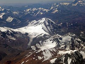
Tupungato, one of the highest mountains in the Americas, is a massive Andean stratovolcano dating to Pleistocene times. It lies on the border between the Chilean Metropolitan Region (near a major international highway about 80 km (50 mi) east of Santiago) and the Argentine province of Mendoza, about 100 km (62 mi) south of Aconcagua, the highest peak of both the Southern and Western Hemispheres. Immediately to its southwest is the active Tupungatito volcano, which last erupted in 1987.
Contents
Map of Tupungato, Mendoza Province, Argentina
The mountain gives its name to the Tupungato Department, an important Argentine wine producing region in the Mendoza province.
1947 plane crash
On August 2, 1947, the airliner Star Dust, an Avro Lancastrian carrying six passengers and five crew over the Andes range, crashed into a steep glacier high on the Argentine side of Tupungato. The plane was quickly buried in the resulting avalanche and heavy snowfall that was taking place at the time. The plane lay undetected deep beneath the snow and glacial ice for over 50 years, before its remnants finally re-emerged at the glacier terminus in 2000. Shortly thereafter, an Argentine army expedition discovered the scattered debris and wreckage, collecting some of the evidence for investigation.