Max. length 20 kilometres (12 mi) Max depth 220 m Area 100.2 km² Volume 8.68 km³ Shore length 118 km | Max. width 10 kilometres (6.2 mi) Surface elevation 358 m Length 20 km Width 10 km | |
 | ||
Surface area 100.18 km (38.68 sq mi) Water volume 8.68 cubic kilometres (2.08 cu mi) | ||
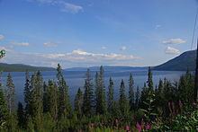
Tunnsjøen (Southern Sami: Dåtnejaevrie) is a lake in the municipalities of Røyrvik and Lierne in Nord-Trøndelag county, Norway. The 100.18-square-kilometre (38.68 sq mi) lake lies just south of the large lake Limingen, and just west of the border with Sweden. It is 358 metres (1,175 ft) above sea level and has a volume of 8.68 cubic kilometres (2.08 cu mi). The deepest part of the lake is 220 metres (720 ft) deep. It is the seventh largest lake in Norway.
Contents
Map of Tunnsj%C3%B8en, Norway
Gudfjelløya
The island Gudfjelløya (Southern Sami: Tjåehkere) lies in Tunnsjøen lake. It has a high point of 812 metres (2,664 ft) above sea level, which is 454 metres (1,490 ft) higher than the lake. This makes Gudfjelløya the highest island on a lake in Norway.
References
Tunnsjøen Wikipedia(Text) CC BY-SA
