
Age of rock 200.132712 million years | Elevation 354 m | |
 | ||
Similar Mount Grace, Peaked Mountain, Mount Watatic, Mount Toby, Little Monadnock Mountain | ||
Tully mountain orange ma
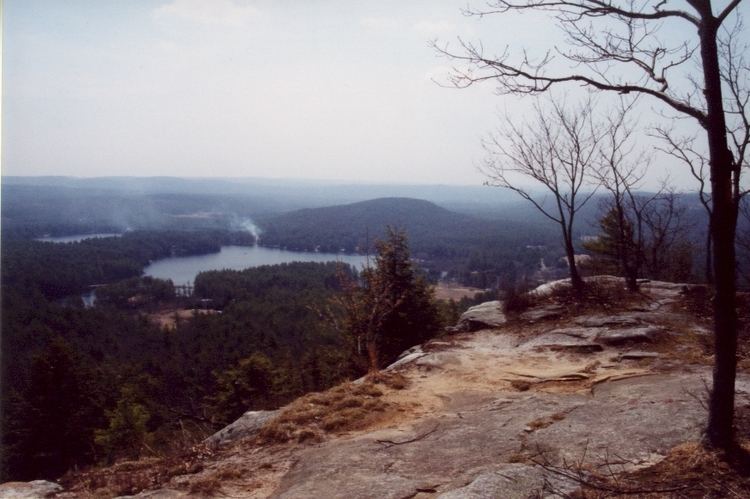
Tully Mountain, 1,163 ft (354 m), is a prominent, steep-sided monadnock located in north central Massachusetts in the town of Orange. An exposed east facing ledge on the summit provides views of the Millers River valley, Mount Monadnock, Mount Wachusett, and the Wapack Range. The 22-mile (35 km) Tully Trail traverses the mountain.
Contents
Map of Tully Mountain, Orange, MA 01364, USA
There exists a Tully Mountain (Ireland) that, at 1168 feet above sea level, is almost identical in elevation to the Tully Mountain in Massachusetts.
The mountain drains into the Tully River, then into the Millers River, then to the Connecticut River and Long Island Sound.
The mountaintop is forested, except for a rocky outcropping (a monadnock) that faces due east; the rocky ledge of Tully Mountain is visible from surrounding small towns and is a defining characteristic of this small mountain. The rocky vantage point is the "practical" summit of the mountain, as the geological summit is wooded, unmarked, and without views. The vista, looking afar from the steep ledge, features Mount Monadnock (Jaffrey, NH, approx 20 miles NE); to the left/north of Mount Monadnock is Mount Kearsarge (Merrimack County, New Hampshire); the tallest mountain in the distant southeast is Mount Wachusett; also visible is the church steeple of Royalston, MA, and three bodies of water: Tully Lake (due east, with views of automobile traffic across the dam), Packard Pond (including its private beach), and the lily-padded Tully Pond (south east). On a clear day, when trees are leafless, looking due south-southwest, some claim to see the Quabbin Reservoir between the distant hills. Visible in the southern view is the town of Athol, Massachusetts, with its uptown, downtown, and various steeples and smokestacks.
The mountain actually has twin "peaks" topographically, having a smaller 856-ft elevation to its south, near Tully Pond, and is sometimes referred to as Little Tully Mountain. Little Tully Mountain is clearly visible from Tully Mountain, but is seldom climbed as it is forested.
Access to hike up the mountaintop of Tully Mountain is typically by two routes: (a) from a pathway starting at the Tully town cemetery, just south of Tully mountain, on a route that traverses Little Tully Mountain, or (b) from a small dirt parking area adjacent to the bridge over the Tully River, just west of the mountain, on Tully Road; this pathway follows a wide cart-path around the base of the mountain for about 1/4 mile, and then ascends along a yellow blazed trail. There is signage on the Tully trail indicating that Royalston Falls is approximately 10 miles, by foot, from Tully Mountain. There is no defined trailhead signage, and there is no fee. Total hiking time one-way to the vista is approximately 20-30 minutes, making this a common destination for hikers of all ages, active families, and teenagers looking for a spot to do what teenagers do.