
Age of rock 400 million yrs. Mountain range Chugach Mountains | Elevation 493 m Easiest route Metacomet-Monadnock Trail | |
 | ||
Location Warwick, Massachusetts. Parent range Upland plateau of central Massachusetts Mountain type monadnock; metamorphic rock Similar Tully Mountain, Crag Mountain, Little Monadnock Mountain, Mount Toby, Massaemett Mountain | ||
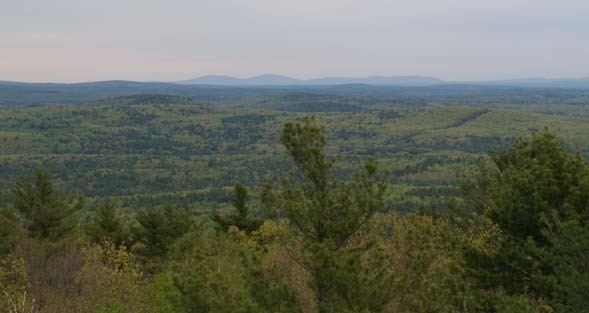
Mount Grace, 1,617 feet (493 m), is a prominent monadnock located in north central Massachusetts in the town of Warwick, approximately two miles south of the New Hampshire border. The mountain is rugged and largely wooded, but a firetower on the summit provides expansive views of the surrounding rural countryside. Little Mount Grace, 1,226 feet (374 m), is the southern summit of the mountain. Mount Grace supports a predominantly northern hardwood forest as well as stands of red spruce near its summit.
Contents
- Map of Mt Grace Warwick MA 01378 USA
- Potters bar 1985 mount grace school sing loud for africa
- HistoryEdit
- Picnic areaEdit
- Recreation and conservationEdit
- Warwick Fire TowerEdit
- References
Map of Mt Grace, Warwick, MA 01378, USA
The north side of Mount Grace drains into the Ashuelot River, thence into the Connecticut River, then Long Island Sound; the west side drains into the Connecticut River via Mill Brook; and the south and east sides drain into the Millers River, thence into the Connecticut River.
Potters bar 1985 mount grace school sing loud for africa
HistoryEdit
Mount Grace is named after Grace (Sarah) Rowlandson, the daughter of Mary Rowlandson, a Puritan colonist of Massachusetts. Grace died after she and her mother were captured by Native Americans of the Narragansett Tribe during King Philip's War in 1676. She was reportedly buried at the foot of the mountain.
Picnic areaEdit
In the 1930s, the Civilian Conservation Corps built a picnic area on the west side of Route 78, at the bottom of the mountain, below the Gulch. The banks of the brook were walled with stone. The Corps also built a picnic area with stone fireplaces and grills, and road access to it. The hardwoods were thinned out, leaving only the White Pines.
In the 1980s, the State ceased maintaining the picnic area. Brush grew up. The area started the transition back to forest. By the late 1990s many of the big White Pines were dead. The State logged the area, and left the slash on the ground to help new trees grow.
The summit also has a small picnic area, but as of August 2015, the picnic table has been dismantled or destroyed.
Recreation and conservationEdit
Mount Grace is located within the 1,458-acre (590 ha) Mount Grace State Forest. Hiking, backpacking, hunting, horseback riding, cross-country skiing, mountain biking, and snowshoeing are enjoyed on the mountain. The 114 mile (183 km) Metacomet-Monadnock Trail traverses the summit. A lean-to on the east side of the mountain is available for primitive camping.
In 2000, Mount Grace was included in a study by the National Park Service for possible inclusion in a new National Scenic Trail; tentatively in 2007 the project was on course to be called the New England National Scenic Trail, which would include the Metacomet-Monadnock Trail in Massachusetts, and the Mattabesett and Metacomet trails in Connecticut. In 2009 President Obama signed a bill making the M & M Trail part of the National Scenic Trail system.
The Mount Grace Land Conservation Trust, active in the area, takes its name from Mount Grace.
Warwick Fire TowerEdit
Warwick Fire Tower is a fire lookout tower on the summit of the mountain. The first Warwick Fire Tower was a 40’ iron windmill type tower with a ladder and 6’x6’ cab built in 1911. It was replaced in 1920 with a 68’ iron tower that served until blown down by the 1938 hurricane. The present 68’ steel tower with 10’x10’ wooden cab was constructed in 1939. In spring of 2010, the fire tower was completely rehabilitated. It remains in service as an active state tower. It is staffed from March–May, and late August–October depending on fire danger. In 2004 this tower was listed on the National Historic Lookout Register as US 628, MA 39.