
Formed August 26, 2009 Fatalities 1 direct Highest winds 97 km/h | Dissipated August 29, 2009 Damage Minimal | |
 | ||
Lowest pressure 1006 mbar (hPa); 29.71 inHg Date 26 August 2009 – 29 August 2009 Similar Hurricane Danny, Tropical Storm Claudette, Tropical Storm Grace, Hurricane Bill, Tropical Storm Erika | ||
Tropical Storm Danny was a weak and disorganized tropical cyclone that formed in August 2009. The fourth tropical system and third named storm of the 2009 Atlantic hurricane season, Danny developed on August 26 from the interaction between a westward-moving tropical wave and an upper-level trough while situated east of the Bahamas. The storm never fully matured, and resembled a subtropical cyclone. It meandered generally northwestward before being absorbed into another weather system on August 29.
Contents
Danny had only minor effects on land. However, it triggered high surf and rip currents from Florida through the Mid-Atlantic states, leading to the death of a 12-year-old boy in North Carolina. The cyclone's remnants contributed to widespread rainfall in the northeast United States. At one point, some weather forecasts predicted Danny to rapidly strengthen, and hit Nantucket as a Category 1 Hurricane, although this never occurred. Localized flooding was reported, particularly in Pennsylvania. It later caused heavy precipitation and power outages in Atlantic Canada.
Meteorological history
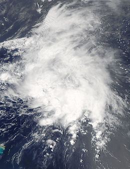
Danny originated in a tropical wave that exited the west coast of Africa on August 18 and entered the Atlantic Ocean. Convective activity associated with the system briefly showed signs of organization on August 22; however, wind shear stunted further development. On August 24, shower activity once again increased as the disturbance interacted with an upper-level trough. On the afternoon of August 25, the National Hurricane Center assessed a high chance of tropical cyclone formation within 48 hours. That same day, a Hurricane Hunters mission into the system revealed a broad area of tropical-storm force winds, but no closed circulation center. However, around 0900 UTC on August 26, satellite imagery and QuikSCAT information indicated that a closed circulation had formed. While situated about 430 mi (690 km) to the east of Nassau, Bahamas, the feature was declared a tropical storm—skipping the tropical depression stage.
Due to the interaction of the initial wave and the upper-level trough, Danny maintained a "non-classical" structure resembling that of a subtropical cyclone. Even after its designation as a tropical storm, the storm was highly disorganized. Little or no deep thunderstorm activity surrounded the center, and the highest winds in relation to the cyclone were confined to a rainband in the northern semicircle. The storm moved erratically northwestward throughout the day, strengthening slightly. Danny's center reformed several times, making it difficult to determine its exact forward motion.
By early on August 27, the tropical storm became slightly better organized, although the most intense winds were still removed from the center. Danny peaked with maximum sustained winds of 60 mph (95 km/h) and a minimum pressure of 1006 mbar (hPa; 29.71 inHg). It held this strength for about 12 hours before wind shear caused the storm to gradually weaken as it meandered northward. By August 28, Danny further deteriorated, and reconnaissance aircraft found that it was barely a tropical storm. After stalling during the afternoon, the center resumed a north or north-northwestward drift.
A strong upper-level trough moving through the southeastern United States forced Danny northeastward, which also triggered the formation of another low pressure system near the coast of North Carolina early on August 29. Although this low formed within Danny's cyclonic envelope, satellite imagery indicated that it did not have the characteristics of a tropical cyclone. Therefore, it is not considered to be a continuation of Danny. The new low caused the tropical storm to degenerate into a trough about 275 mi (445 km) southeast of Wilmington, North Carolina, and Danny's remnants were absorbed into a developing frontal zone shortly thereafter.
Impact
In advance of the cyclone, a tropical storm watch was posted for North Carolina from Cape Lookout to Duck at 2100 UTC on August 27. It was discontinued on August 29.
Since the storm remained offshore for the most part, its effects were limited. However, it generated strong rip currents and rough waves on the U.S. East Coast which may have resulted in the crowning death of a 12-year-old boy near Corolla, North Carolina on August 28. On September 1, the Currituck County Sheriff's Office reported that the boy's body was found on the beach about 1 mi (1.6 km) north of where he went missing. Farther south, Danny generated waves 6 to 7 ft (1.8 to 2.1 m) in height along Florida's Atlantic coast. High surf and rip currents also affected the Mid-Atlantic states, prompting officials to issue bathing restrictions. A surfer in Monmouth County broke his leg in the rough conditions.
The remnants of the storm interacted with a frontal boundary, triggering widespread rainfall in numerous states which led to localized flooding. In Delaware County, torrential rainfall produced flash flooding that trapped one family in their basement. A creek near Philadelphia overflowed its banks and caused minor flooding. Several roads in Lehigh County, including one lane of U.S. Route 222, were closed due to flood waters. Flooding also took place in New Jersey; numerous basements were submerged and water rescues from vehicles were performed in Camden County. Isolated reports of 7 in (180 mm) of precipitation were received in Maryland.
Once extratropical, the system impacted New England with high winds and heavy rainfall. At least 2 in (51 mm) of rain fell in Massachusetts and Rhode Island. Some roads throughout the region became impassable due to standing water. A site in the Nantucket Sound recorded a wind gust to 61 mph (98 km/h). The former tropical cyclone produced wind gusts of 60 mph (97 km/h) in Maine, toppling trees and ripping boats from their moorings at a harbor in Eastport. The system also brought heavy rainfall to the area.
Danny's remnants later caused heavy rain across Atlantic Canada. At Saint John, New Brunswick, 100 mm (3.9 in) of rain fell, and at least 50 basements were flooded. The Meteorological Service of Canada declared several weather advisories for New Brunswick, Newfoundland, Prince Edward Island and Nova Scotia. In Nova Scotia, during the storm's worst, over 16,000 residences lost power.