
Formed August 14, 1993 Fatalities 4 total Highest winds 64 km/h | Dissipated August 17, 1993 Damage $19 million (1993 USD) | |
 | ||
Lowest pressure 1007 mbar (hPa); 29.74 inHg Date 14 August 1993 – 17 August 1993 Affected areas British Virgin Islands, Puerto Rico, Martinique, United States Virgin Islands, Dominican Republic, Lesser Antilles Similar Tropical Storm Franklin, Hurricane Cindy, Tropical Storm Gert, Tropical Storm Bret, Tropical Storm Jose | ||
Tropical Storm Cindy was a weak but unusually wet Atlantic tropical cyclone that caused disastrous floods and mudslides across Martinique in August 1993. Forming east of the island, Cindy became the annual hurricane season's third named storm on August 14. Due to unfavorable atmospheric conditions, the storm remained disorganized throughout its journey across the northeastern Caribbean Sea. After attaining maximum sustained winds of 45 mph (75 km/h), Cindy began to weaken from interaction with the high terrain of Hispaniola. It made landfall in the Dominican Republic as a tropical depression on August 16, and dissipated over the territory the following day.
Contents
Despite its poor cloud and wind structure, Cindy dropped torrential rain over portions of the northeastern Caribbean. The island of Martinique received a record 12 inches (305 mm) of rain over a 24-hour period, affecting many northern villages and communes. Le Prêcheur in particular was devastated by an extensive debris flow, which washed away entire structures. The disaster left two people dead and hundreds homeless on the island, and wrought $19 million (1993 USD) in damage. En route to Hispaniola, Cindy affected the Virgin Islands and Puerto Rico with rough surf and moderate rain. Heavy downpours and flooding killed two people in the Dominican Republic, though the exact extent of the damage there is unknown.
Meteorological history
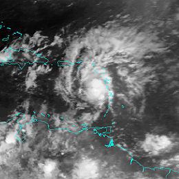
The origins of Tropical Storm Cindy can be traced to a tropical wave that departed the western coast of Africa on August 8, 1993. Over the following days, the wave tracked steadily west-northwestward across the tropical Atlantic while retaining a distinct cloud pattern on satellite images. Although initial data from a reconnaissance aircraft mission on August 13 indicated that the system lacked a defined wind circulation, a second mission at 1200 UTC the next day revealed an improvement in its structure at the lower levels of the atmosphere. The National Hurricane Center (NHC) thus classified the system as a tropical depression—a tropical cyclone with sustained winds of less than 39 mph (62 km/h)—and initiated public advisories on it soon thereafter.
Steered by a mid- to low-level wind flow, the depression decreased in forward speed and continued west-northwest toward Martinique. Satellite images showed the development of a central dense overcast, and reconnaissance soon revealed that wind speeds near the center had increased to gale force. Based on this, the NHC upgraded the depression to Tropical Storm Cindy at 1800 UTC on August 14, at which time the cyclone was located over Martinique with winds of 40 mph (65 km). Although Cindy briefly developed a favorable outflow, its upper-level structure debilitated after it moved away from the Lesser Antilles, preventing further development. Over the course of August 15, Cindy's cloud pattern remained disorganized due to unfavorable wind shear; the center of circulation became ill defined, with the strongest thunderstorms confined to the eastern portion of the cyclone. Despite the unfavorable conditions, the storm managed to strengthen marginally on August 16, attaining its peak intensity with winds of 45 mph (75 km/h) and a minimum pressure of 1007 mbar (hPa; 29.74 inHg), roughly 85 mi (140 km) southeast of Santo Domingo.
Shortly after peaking in strength, Cindy began to interact with the mountains of nearby Hispaniola. The high terrain disrupted its circulation, causing it to weaken to a tropical depression around 2100 UTC on August 16. The depression made landfall near Barahona, Dominican Republic, with winds of 35 mph (55 km/h). It became increasingly disorganized over land, prompting the NHC to declassify it as a tropical cyclone on August 17. The remnants proceeded inland near the border with Haiti and emerged into the Atlantic, where they spread across the Bahamas before eventually dissipating the next day.
Preparations
When Cindy became a tropical cyclone on August 14, tropical storm warnings were issued for the Lesser Antilles from Martinique northward to the Virgin Islands. A tropical storm watch was posted for Puerto Rico at the time. The warnings, excluding those for the Virgin Islands, were discontinued on August 15. As Cindy drifted further north later that day, the watch for Puerto Rico was upgraded to a tropical storm warning. Officials issued flash flood warnings for parts of the island, and about 600 people living in flood-prone areas sought shelter ahead of the storm. Ferry service between Fajardo and the offshore islands of Culebra and Vieques was suspended, leaving about 400 passengers stranded for a day. A price freeze was placed on emergency supplies such as wood, nails, batteries, kerosene, and lanterns.
Also on August 15, a tropical storm warning was issued for the Dominican Republic, from Samaná to Cabo Engaño along the northern coast and westward to Isla Beata off the southwestern coast. Thousands of residents stocked up on bottled water, canned goods, and gas, though stores in and around the capital remained closed for the day. The Santo Domingo International Airport suspended all flight operations on the morning of August 16. The tropical storm warning for the island was discontinued when Cindy made landfall as no more than a weak tropical depression. In Cuba, a storm alert was issued for eastern provinces as forecasters warned of possible heavy rainfall.
Lesser Antilles
On August 14, Cindy passed over Martinique with rough winds and particularly violent rain. The greatest quantities fell to the northeast of a line between Sainte-Marie and Fort-de-France, with day totals of more than 4 in (100 mm) recorded at every weather station in that region. The highest 1- and 24-hour rainfall rates were observed in Le Prêcheur, totaling 5.79 in (147 mm) and 12.0 in (305 mm), respectively. These amounts were well above the September average of 9.29 in (236 mm), making Cindy one of the most extreme rain events in the island's history. A maximum gust of 40 mph (65 km/h) was recorded during the storm, though sustained winds onshore did not reach tropical storm force.
Initially, Cindy's brisk winds downed banana trees and power lines across northern Martinique. After hours of continued rain, several rivers—such as the Rivière des Pères, Rivière Claire and Rivière Sèche—quickly swelled and overflowed. Heavy flooding and mudslides swept through northern villages, submerging homes and destroying roads and bridges. News footage on national television showed "cars [being] swept away to sea and buried in mud". The Prêcheur River, which normally flows at 18 ft3/s (0.5 m3/s), burst its banks upon attaining an exceptional discharge rate of nearly 25,000 ft3/s (700 m3/s). Large amounts of volcanic matter from the riverbed congealed into a massive debris flow that struck the small commune of Le Prêcheur. Reaching heights of up to 10 ft (3 m), the debris completely covered houses and roads and wreaked an estimated ₣15 million (1993 value; $2.7 million in 1993 USD) in structural damage. Flash floods following the overflow of the Grande Rivière surged through the adjacent village of the same name, devastating property and drowning one person. Despite recent improvements to its flood defenses, the Rivière Roxelane rapidly topped its banks and inundated much of Saint-Pierre. Farther south, a combination of torrential rainfall and poor storm drains resulted in widespread flood damage to private property and an aquafarm in Le Morne-Vert.
In all, Cindy killed 2 people, injured 11, and destroyed more than 150 homes across Martinique. Monetary losses reached ₣107 million ($19 million), with road damage pinned at ₣68 million ($12 million). After the storm's passage, thousands of people on the island sought refuge in emergency shelters, and about 3,000 residents became homeless. La Capricieuse, a French Navy ship stationed in French Guiana, delivered disaster relief supplies to Fort-de-France; the goods included 250 packages with clothing items, distributed by the Lions Club Association of Saint Barthélemy. Unseasonable sea conditions in Cindy's wake temporarily hindered local fishers from selling their catch to trading vessels in Petite Martinique. Due to the severity of the flooding in Martinique, waterways and harbors were dredged and river banks and dykes were reinforced to prevent recurrence.
Minimal effects were felt elsewhere in the Lesser Antilles. In Guadeloupe, the storm dropped rain across southern Basse-Terre Island through August 14–15; a peak total of 9.02 in (229 mm) was recorded at the summit of La Grande Soufrière. Wind gusts at Raizet Airport reached 38 mph (61 km/h), just below tropical storm force. Moderate breeze embedded with gusts to 28 mph (44 km/h) brushed Dominica, and 1.25 in (32 mm) of rain fell at Canefield Airport within 24 hours of Cindy's passage. Further south, a weather station in Saint Lucia recorded 1.88 in (48 mm) of precipitation, as well as light winds. As Cindy passed south of the Virgin Islands, unsettled seas and minor beach erosion affected the islands' southern shores, with swells of 4 to 5 ft (1.2 to 1.5 m) reported at Saint Croix. Onshore, the island experienced wind gusts to 35 mph (55 km/h) and 1.48 in (38 mm) of rainfall.
Greater Antilles
On August 16, Cindy made its closest point of approach to Puerto Rico, although its center remained well south of the island. Impact from the storm was thus limited to intermittent downpours and 8 ft (2.4 m) waves along the southern coast. The rough seas caused some minor erosion to beach facilities. According to a report from the United States Geological Survey (USGS), a maximum of 5.54 in (141 mm) of rain fell near Río Cerrillos in Ponce, though the highest measurement from the Weather Prediction Center (WPC) was 4.60 in (117 mm) at Puerto Real in Cabo Rojo. Many other locations received rainfall amounts of 2.0–4.5 in (50–115 mm), which flooded some roads and low-lying areas.
Cindy brought considerable rainfall to southern and eastern parts of the Dominican Republic, with totals of 4–10 in (100–255 mm). Upon the storm's landfall in the country, winds reached 35 mph (55 km/h) in Barahona. The rain filled rivers and caused scattered street flooding, affecting hundreds of houses. In Villa Altagracia, one fatality occurred when a child drowned in flood waters; the final death toll for the country stood at two. There were no reports of damage elsewhere after Cindy's rapid demise over Hispaniola, though it is likely that the remnants produced localized showers in Haiti.