
Opened 3 December 1994 No. of lanes 4 (two each direction) Number of lanes 4 (two each direction) | Route E08 Character Automotive Lowest elevation -102 m | |
 | ||
Length 3,500 m (11,500 ft; 2.2 mi) | ||
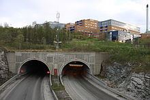
The Tromsøysund Tunnel (Norwegian: Tromsøysundtunnelen) is an undersea highway tunnel under the Tromsøysundet strait, connecting the island of Tromsøya with the mainland in the city of Tromsø in Troms county, Norway.
Map of Troms%C3%B8ysundtunnelen, 9024 Troms%C3%B8, Norway
The tunnel is part of European route E08, (whose northern terminus is on the island itself) and it consists of 2 tubes, each with two driving lanes. The two tubes are not equal in length; one tube is 3,500-metre (2.2 mi) long and the other is 3,386-metre (2.1 mi) long. The lowest point in the tunnels is 102 metres (335 ft) below sea level, and the maximum grade is 8.2%. The two tubes are linked by 15 service-tunnels.
The tunnel opened on 3 December 1994 to relieve Tromsøya's only other mainland connection, the Tromsø Bridge, which had been plagued by severe traffic congestion for more than a decade. The tunnel is located to the north of the bridge; on the island side it emerges just below the University of Tromsø and the University Hospital of North Norway, both major sources of traffic between the island and the mainland; on the mainland side it emerges at Tomasjord which is centrally located between the densely popluated suburbs of Tromsdalen and Kroken.