
Area 6.13 km² Population 296 (1999) | Time zone CET (UTC +1) (UTC+1) Local time Saturday 11:08 AM | |
 | ||
Weather 11°C, Wind NE at 37 km/h, 57% Humidity | ||
Tromborn ( [tʁɔ̃bɔʁn]) is a commune in the Moselle department in Grand Est in north-eastern France.
Contents
- Map of 57320 Tromborn France
- Geography
- Climate
- Agriculture
- Forests
- Wildlife
- Transport
- Demography
- Religious buildings
- References
Map of 57320 Tromborn, France
Geography
Tromborn is a rural village located at the center of the triangle formed by the towns of Bouzonville, Boulay and Creutzwald. The commune is located 3 km from the German border. Tromborn is 32 km from Metz, 6 km from Saarlouis and 11 km from Boulay.
An orientation table provides an overview of the valley of the Nied where footpaths are also listed on a map. From this overview, it's possible to see Luxembourg and Malbrouck Castle, located more than 30 km away, just with binoculars. The Vosges Mountains, located about 100 km away, can be observed in clear weather with a hand-held telescope or telephoto lens.
Near the village:
Visual landscape cues:
Climate
Tromborn has an oceanic climate with temperate summers (Cfb in the Köppen climate classification). Given its position on a plateau, the village is constantly swept by winds. Tempestuous winds are exceptional but sometimes cause damage to roofs and trees, average wind speed is 20 km/h.
Agriculture
Agriculture in the village grew into a landscape of open fields. Two-thirds of the surface of Tromborn (about 4 hectares) are agricultural land. There is intensive production of wheat, barley and maize and industrial crops such as rapeseed. Today there are still some meadows, some of which are used for breeding sheep and cows.
Forests
The forest area extends over a quarter of the area of the village, a total of around 1.5 hectares. Note the presence of beech, of spruce, of oak, of charm and coppicing.
Wildlife
A number of rare bird species are found in the region, such as the corncrake, the Eurasian hobby, the curlew and the common grasshopper warbler. Other species have been seen, such as the red kite, the blue tit, the buzzard, the pheasant, the marbled white butterfly, the kestrel and the wagtail. The forest area of the village is inhabited by the common species to the region such as wild boar, deer and fox.
Transport
The village is located at kilometer 32 of the departmental route 954 which extends from west to east of Metz (km 0) to Saarlouis (38 km), passing through Boulay-Moselle (km 21). Roads run from Dalem, Rémering, Villing, Oberdorff, Brettnach and Téterchen to the village.
Tromborn lacks its own railway station, the closest are those of Bouzonville 7 km away, Saint-Avold 27 kilometres (17 mi) away and Metz 35 km (22 mi) away.
The nearest access to the French motorway network is 16 km (10 mi) away at Boulay-Moselle on the A4.
Access to the German motorway network located 8 km (5 mi) from the village is through the exchange of Saarlouis in the direction of Luxembourg, Saarbrücken, Trier and Mannheim.
The closest civilian airports are those of Metz-Nancy-Lorraine 60 km (37 mi) away, Luxembourg 82 km (51 mi) away and Strasbourg 172 km (107 mi) away.
Tromborn's postal code is 57320, which is the post office number of Bouzonville.
Demography
The 1872 census indicates a population decline in the town. Tromborn is a cereal village, the agricultural crisis of the 1890s and the 1914-1918 war accentuated the rural exodus.
The town is too far from the new industrial centers of the 20th century, many workers and small landowners permanently abandoned their native villages for the cities.
Demographic curve since 1800
Historical decline between 1936 and 1946 is due to the total destruction of the village at the beginning of the Second World War.
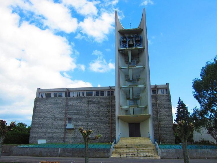
Religious buildings
The Church of St. Martin has avant-garde architecture designed by architects Roger Fraisse and Madeline Felix 62 years ago. Its construction was completed in 1955 and renovations were made at the beginning of the 21st century.
A bell dating from 1695 was once located on the steeple of the church of St. Martin. It is still used today on the ground in the straight extension of the nave inside the building. Its presence since 322 contributes to Tromborn's heritage.
At the beginning of the 21st century, a chapel was built inside the village cemetery.