Treis-Karden is an Ortsgemeinde – a municipality belonging to a Verbandsgemeinde, a kind of collective municipality – in the Cochem-Zell district in Rhineland-Palatinate, Germany. It was the seat of the former like-named Verbandsgemeinde until 1 July 2014. Since then, it is part of the Verbandsgemeinde Cochem. Treis-Karden is a state-recognized tourism resort (Fremdenverkehrsort).
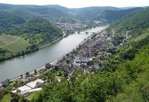
The municipality lies on the river Moselle, roughly 10 km eastnortheast of Cochem.
According to the latest research findings, Treis had its first documentary mention in 762 as trisgodros villa publica. The document in question is actually a 10th-century copy in Prüm Abbey’s Liber aureus. There were holdings at Treis owned by Polish queen Richeza, Count Palatine Ezzo’s daughter, who apparently donated her property in 1051 and 1056 to the Brauweiler Monastery near Cologne. Beginning in the 11th century, Saint Castor’s Foundation (Stift St. Kastor) in Karden had, by way of donations and purchases, important landholdings. In 1103, Ravengiersburg Monastery obtained by way of trade with St. Stephan in Mainz an estate in Treis (curtis in Tris). The name Karden is a modern form of the name for a Roman vicus, named in the latter half of the 5th century as Cardena by the geographer of Ravenna. In the late 6th century, Karden was the centre of a greater parish out of whose college of priests arose Saint Castor’s Foundation in the 9th century. In 926, an exchange agreement contained the reference in Karadone, and in the 11th century, Karden was named as villa Cardiniacus
Saint Castor is held to have founded a Christian community in Karden as early as the 4th century. Castor’s bones went in the 9th century mostly to Saint Castor’s Church (Kastorkirche) in Koblenz. In antiquity and in the Middle Ages, Karden was a place of importance whose history was defined by the collegiate foundation that existed here until 1802. Karden was the centre of an archdeaconry. The foundation’s provost was through personal union one of the five archdeacons of the Archbishopric of Trier.
Treis was the main centre of the Trechirgau. When this gau’s counts, the Berthold-Bezeline family, died out in the late 11th century, it led to a whole series of disputes. For their part, the Counts of Salm-Rheineck sought to bring Treis along with its environs under their yoke. As early as 1121, Heinrich V destroyed the castle to support Count Palatine Gottfried von Calw. Apparently, Otto von Salm had only just had the castle newly built. In the struggle waged by Otto II von Rheineck (Otto von Salm’s son) against Hermann von Stahleck over the Rhenish Electoral Palatinate, Treis eventually fell under Electoral-Trier lordship in 1148, remaining there until the late 18th century.
Beginning in 1794, both centres lay under French rule. In 1815 they were assigned to the Kingdom of Prussia at the Congress of Vienna. Since 1946, they have been part of the then newly founded state of Rhineland-Palatinate. On 7 June 1969, the two centres, until then each a separate municipality, were merged to form the new municipality of Treis-Karden.
The council is made up of 16 council members, who were elected at the municipal election held on 7 June 2009, and the honorary mayor as chairman.
The municipal election held on 7 June 2009 yielded the following results:
Since 2007, Philipp Thönnes (CDU) has been Treis-Karden’s mayor. He succeeded Harry Dienes (CDU). His deputies are Tino Knaup and Dieter Bamberg.
The German blazon reads: Wappen geviert. In Feld 1: ein goldener Stern in Schwarz, in Feld 2: im goldenen Feld ein roter Einhenkelkrug, in Feld 3: eine blaue Lilie in silbernem Feld, in Feld 4: in schwarzem Feld ein goldener Hammer, umwunden von zwei goldenen Schlangen.
The municipality’s arms might in English heraldic language be described thus: Quarterly, first sable a mullet of five Or, second Or a jug with one handle to sinister gules, third argent a fleur-de-lis azure, and fourth sable a hammer palewise coiled in opposite directions around which two serpents of the second.
The mullet (star shape) can already be found in the 1519 Treis court seal; it was also borne as a charge by the Castle Counts (Burggrafen) of Treis. The one-handled jug refers to the potter’s craft, which was practised throughout Roman times in Karden. Several pieces of this kind can be found in the Foundation museum. The lily appears in the seal of the Collegiate Foundation in Karden from the latter half of the 13th century; it also refers to Mary, the church’s former patron. The hammer with two snakes wound onto it refers to the arms borne by the family Broy in Karden. It can be found on several tomb slabs and the winged altar in the Foundation church, as well as on the door lintel of the so-called Burghaus.
In 1977, municipal council commissioned heraldic artist A. Friderichs and local historian H. Ritter to submit designs for a coat of arms. At a session on 18 July of that year, council chose the design that the municipality now bears as its arms, although they insisted on a slight modification to the charge in the second quartering, which was originally to have been an amphora. The arms have been borne since 14 February 1978.
The following are listed buildings or sites in Rhineland-Palatinate’s Directory of Cultural Monuments:
Former Saint Castor’s Foundation Church, St.-Castor-Straße – whole complex with cloister and Foundation museumEvangelical church (Georgskapelle), Moselstraße 33 – Gothic aisleless church, mid 14th centuryHochkreuzkapelle (“High Cross Chapel”) with Stations of the Cross, Kastellauner Straße – chapel, aisleless church, marked 1754, inside Crucifixion group, 18th century; Way of the Cross, Bildstock type with relief, 19th centurySaint Castor’s Foundation zone (monumental zone) – from buildings’ condition and bordering still a complex that can well be made out with buildings surrounding the former Saint Castor’s Foundation Church used by the Foundation lords and the canons, the Haus Korbisch (former provostry building), former Foundation school and former dormitory stretching to the Brohlbach flowing behind it and down to the Electoral-Trier Amtshaus on the MoselleAm Buttermarkt 2 – L-shaped complex; timber-frame house, partly solid, plastered, marked 1631; front wing, 18th century; whole complexAm Buttermarkt 6 – former Foundation gate; three-floor timber-frame house, partly solid, balloon frame, dendrochronologically dated to 1310, corner stud dendrochronologically dated to 1516 ± 5 yearsKernstraße 5 – timber-frame house, partly solid, 18th centuryKernstraße 8-10 – former Foundation lords’ building (possibly refectory/dormitory) and refectory; Late Romanesque plastered building, dendrochronologically dated to 1238Kernstraße 9 – timber-frame house, partly solid, 18th centuryKernstraße 18 – former Foundation school; timber-frame house, partly solid, Late Gothic crow-stepped gable (dendrochronologically dated to 1426/1427)Lindenplatz – Castor-Brunnen (fountain), 20th centuryFriedhof, Maximinstraße – three-floor Romanesque quarrystone tower of the old parish church, 13th century; eleven grave crosses from the 18th and 19th centuries; Crucifixion group, 18th centuryMoselstraße 18 – former Electoral-Trier Amtshaus; quarrystone building, timber-frame oriel turret, staircase, 1562Moselstraße 27 – villa; Late Historicist quarrystone building, hipped mansard roof, about 1900; whole complex with gardenMoselstraße 32 – timber-frame house, partly solid, marked 1464 (?), 1686; on uphill side balloon frame construction, essentially possibly from the 16th century, side facing the Moselle from the 17th century; garden with garden wall; whole complexBetween Moselstraße 37 and 38 – Crucifixion group, Baroque Revival niche, marked 1907, with Baroque Crucifixion group, 18th centuryRömerstraße 28 – archaeological collection from Roman times and the Middle AgesSt.-Castor-Straße – railway station; two-winged building with hipped mansard roof or half-hipped roof, 1910; whole complex with tracksSt.-Castor-Straße 1 – Haus Korbisch; Late Romanesque plastered building with twinned windows and tower; the central part dendrochronologically dated to 941 ± 10 years, re-built with the late Romanesque windows in 1207/08.St.-Castor-Straße 3 – quarrystone building, mid 19th centurySt.-Castor-Straße 7 – timber-frame house, partly solid, 17th century, on ground floor mediaeval fragmentsSt.-Castor-Straße 9/11 – solid building, in the back timber-frame house, partly solid, balloon frame, dendrochronologically dated to 1495; addition, partly timber-frame, 16th centurySt.-Castor-Straße 10 – solid building, partly timber-frame, crow-stepped gable, 16th centurySt.-Castor-Straße 14 – Baroque building with hipped mansard roof, marked 1765, winepress houseSt.-Castor-Straße 17 – timber-frame house (towards back), partly solid, 18th centurySt.-Castor-Straße 23 – timber-frame house, partly solid, balloon frame, marked 1587St.-Castor-Straße 28 – former school; stately quarrystone building, marked 1909St.-Castor-Straße 31 – timber-frame house, partly solid, half-hipped roof, marked 1759St.-Castor-Straße 33 – timber-frame house, partly solid, plastered and sided, half-hipped roof, 18th centurySt.-Castor-Straße 34 – timber-frame house, partly solid, latter half of 16th century, remodelled in 17th centurySt.-Castor-Straße 42 – stately building with hipped roof, 18th century; whole complex with gardenSt.-Castor-Straße 48 – timber-frame house, partly solid, half-hipped roof, marked 1614St.-Castor-Straße 74/76 – timber-frame house, partly solid, plastered, mansard roof, 18th century (?)St.-Castor-Straße 86 – Schlosshotel Petri; two- to three-floor L-shaped plastered building, essentially from the 17th century (?), wing facing the Moselle with crow-stepped gable, 19th century; whole complex with old wallSt.-Castor-Straße 109 – plastered building on high quarrystone pedestal, staircase, 1920s/1930sSt.-Castor-Straße/corner of Maximinstraße – Madonna, 19th centuryVineyard house – timber-frame bungalow with half-hipped roof, towards 1910Gillesmühle – Bildstock, relief, 18th centuryAbove St. Goar, marked by a prominent white cross – Saint Castor’s Cave, grotto with kneeling Christ, 18th or 19th centuryWindhäuser Höfe (estates) on Kreisstraße 31 – Gothic Revival chapel; inside, Gothic Revival Crucifixion groupSaint John the Baptist’s Catholic Parish Church (Pfarrkirche St. Johann Baptist), Am Plenzer – Gothic Revival hall church, quarrystone, 1823-1831, architect Johann Claudius von Lassaulx, KoblenzAm Rathaus 2 – quire of the former Saint Catherine’s Catholic Parish Church (Pfarrkirche St. Katharina), latter half of 15th century; grave cross, marked 1527Am Markt 8 – timber-frame house, partly solid (solid building with timber-frame façade?), half-hipped roof, marked 1637Am Plenzer 1 – former boys’ school; quarrystone building, hipped roof, about 1834, architect Johann Claudius von LassaulxAm Plenzer 5 – Gothic Revival quarrystone building, mid 19th centuryAm Rathaus 4 – quarrystone building, mid 19th century; whole complex of buildings with quarrystone commercial buildingAm Rathaus 5/6 – former rectory; quarrystone building, about 1830/1840, architect Johann Claudius von Lassaulx, with pilaster strips and broad arch frieze; no. 5 winepress house; in the wall four grave crosses, 1747, 1615, 1614, fragment 1733; whole complex of buildings with barn and gardenBreitbrücke – one-arch quarrystone bridge, essentially Baroque, mid 19th century faced by Johann Claudius von LassaulxBrückenstraße 29 – former weights and measures office; one-floor quarrystone building, 1889Burg Treis (castle) – quarrystone keep, between 1152 and 1169, great parts of the fortification, gate, Burgmannenhaus, residential quarters and heated room of the castle complex founded in the 11th centuryCastorgasse 7 – three-floor timber-frame house, partly solid, marked 1819, timber framing marked 1718Castorgasse 13 – see Hauptstraße 16Castorgasse 14 – building with mansard roof, timber framing plastered, marked 1766Fischergasse 1 – timber-frame house, partly solid, marked 1561, remodelled in the 18th centuryFischergasse 12 – timber-frame house, partly solid, plastered, essentially from the 16th or 17th centuryHauptstraße – water cistern; one-floor Baroque Revival quarrystone building with tower, marked 1903Hauptstraße 10 – Classicist timber-frame house, partly solid, plastered, marked 1819Hauptstraße 15 – two houses; solid building, 17th century; timber-frame house, partly solid, half-hipped roof, early 17th century, essentially possibly older, driveway with timber-frame bridgeHauptstraße 16 – L-shaped complex; spacious timber-frame house, partly solid, plastered, mansard roof, marked 1815Hauptstraße 27 – Altes Rathaus (Old Town Hall); Gothic Revival quarrystone building, crow-stepped gable, Gothic Revival niche Madonna, 19th century; characterizes village’s appearanceJohannesstraße 6 – quarrystone building, 19th centuryKastellauner Straße – basalt wayside cross, marked 1637Katharinenstraße 27 – timber-frame house, partly solid, plastered, 17th centuryKirchberger Straße/corner of Forststraße – graveyard with old girding wall, at which two gravestones, 19th century; basalt graveyard cross on altar block, marked 1716, two attendant figures, 18th century; graveyard chapel, quarrystone building, 19th century; “Vesper”, 19th or 20th centuryKirchstraße 7 – building with hipped mansard roof, timber framing plastered, 18th centuryLaygasse 13 – spacious quarrystone building, hipped roof, 19th centuryMittelstraße 1 – timber-frame house, partly solid, essentially from the 16th centuryMoselallee 2 – quarrystone villa, partly timber-frame, about 1900Rainstraße 15 – timber-frame house, partly solid, plastered, essentially from the 16th or 17th centuryRainstraße 19 – timber-frame house, partly solid, plastered, half-hipped roof, essentially possibly from the 16th centuryWehrgasse 5 – three-floor timber-frame house, partly solid, mansard roof, 18th centuryWildburg (castle) – residential quarters, keep, possibly before 1122; whole complexOn Kreisstraße 35, way out of the village going towards Bruttig-Fankel – wayside chapel; quarrystone building, 1932On Kreisstraße 35, going towards Bruttig-Fankel – Gothic Revival wayside cross; about 1900, mosaic from the 1950sOn Kreisstraße 35, going towards Bruttig-Fankel – basalt wayside cross; 18th centuryOn Landesstraße 108, way out of the village – Baroque crossBeurenhof – timber-frame chapel, 17th or 18th centuryFlaumbachtal 4 – former Premonstratensian convent of Maria Engelport; two-naved basilica and new convent wing, quarrystone, 1903-1905; from the old complex girding wall the church consecrated in 1272 and old wing, 16th or 17th century; coat of arms, marked 1716; quarrystone commercial wing; grotto, 1915; on the way to the graveyard sculptures; at the graveyard cast-iron cross, Rheinböllen foundry, latter half of 19th centuryHonshäuserhof – votive cross, marked 1936Zilskapelle St. Johann Baptist (chapel), formerly St. Cyriakus; aisleless church, early 17th century; outside, two reliefs, marked 1783; pilgrimage cross, marked 1845; 14 Gothic Revival Stations of the Cross, stele form, Bildstock type, 19th century, beginning with chapel with grotto, 18th century, inside, Christ on the Mount of Olives, 18th century; whole complex with Way of the CrossThe name of the building Haus Korbisch is a corruption of the German word Chorbischof (“canonical bishop”).
The former Saint Castor’s Foundation Church (Stiftskirche St. Castor) in Karden (originally a Romanesque building) is said to be the Moseldom (“Moselle Cathedral”). A Foundation museum recalls the greatness of the village’s past.Karden railway station is served by Regional-Express trains running between Koblenz, Trier and Saarbrücken.