
 | ||
Transport in São Paulo plays a key role in the date-to-day life of the people of São Paulo. Although lacking in strong infrastructure, various methods of public transport are offered in the city, including a complex bus system run by SPTrans, and various subway and railway lines. A contactless smartcard is used for fare collection for the buses, subway, and railway systems. São Paulo also has three airports.
Contents
Bus System
Over 16,000 buses form the bulk of public transport in São Paulo; they include about 290 trolley buses. Except for a small network overseen by the EMTU, all bus lines are operated by concessionaires under the supervision of SPTrans, a municipal company responsible for the planning and management of public transport. Some of the SPTrans buses are painted in white, while others are painted with region-specific colors. Up until recently, informal transport vans (dab vans) had a large presence in the city, but the vast majority of such vans are now registered with the city council, legalized, and operating under the same color scheme used as the main system. To increase efficiency in the city, São Paulo is implementing a bus rapid transit system called the Expresso Tiradentes. There is also a fast-lane bus system, which are placed on large avenues and connected with the underground or suburban train stations.
Rail transport
The São Paulo Metro has 74.3 km of underground railway systems (34.6 km fully underground), with 5 lines in operation and 64 stations, while the railway system consists of 260.7 km from the Companhia Paulista de Trens Metropolitanos (CPTM) railways. Both CPTM and the underground railway lines carry some 5.2 million people on an average weekday, and a few new underground lines to be constructed are expected to add another million people to the system within the next five years. The projects expected to expand São Paulo's urban railway system from the current 322.2 km to more than 500 km on the next 10 years.
São Paulo used to have tram lines in the first half of the 20th century, but they were eradicated due to the expansion of the bus system.
There are currently 5 lines in the São Paulo Metro:
The following lines are railway lines managed by CPTM:
Future complete system
This table includes future extensions and lines for Metro and CPTM:
Airports
São Paulo has three airports. Two of them, São Paulo/Guarulhos International Airport and Congonhas-São Paulo Airport are located in the metropolitan area, while the third, Campo de Marte, is located north of the city center. Campo de Marte also hosts the Ventura Goodyear Blimp.
Congonhas Airport operates domestic and regional flights, mainly to Rio de Janeiro, Belo Horizonte and Brasília. Guarulhos International Airport, also known to São Paulo dwellers as "Cumbica", is located 25 km North East of the city center, in the neighbouring city of Guarulhos. Guarulhos airport operates both domestic and international flights. Major Brazilian airlines handled by Congonhas Airport and Guarulhos Airport include TAM Airlines, Gol Transportes Aéreos, Azul Brazilian Airlines, and Avianca Brasil. Campo de Marte airport handles some private and small-sized airplanes.
In 2006, about 34.3 million people used the city's airports (mainly from Congonhas and Guarulhos International Airport, the only two operating commercial flights). Infraero, Brazil's main aviation authority, estimates that with the remodelling of Guarulhos Airport, São Paulo's airports will be able to handle about 45 million passengers a year within the next five years.
Heliports
São Paulo has the largest fleet of helicopters in the world, with around 500 registered helicopters and 700 flights per day in the city. The owners are an elite wealthy class who take advantage of approximately one hundred helipads and heliports to conveniently avoid heavy traffic. In addition, there are many air taxi companies in the city, used mostly by the upper class to travel between São Paulo and Rio de Janeiro.
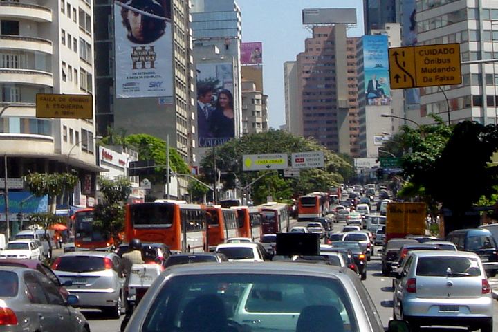
Roads
Many Brazilian highways pass through or start in São Paulo itself, including the BR-116, Rodovia dos Bandeirantes, Rodovia Raposo Tavares, the Rodovia Anhangüera, Rodovia dos Imigrantes, Rodovia Castelo Branco, and Via Dutra.
Rodoanel
The Rodoanel Mario Covas (SP-21) (also known as Rodoanel Metropolitano de São Paulo or simply Rodoanel) is a motorway being built around the center of the metropolitan region of São Paulo in an attempt to alleviate traffic intensity of trucks along the city's two riverside highways (Pinheiros and Tietê).
The Rodoanel is being constructed as a multi-lane, limited-access freeway, with large sections to be built in unoccupied regions: along the edge of forests, close to residential areas, etc. This is in an effort to prevent squatting and development in environmentally sensitive areas along the route. Construction is being carried out in four phases: west, south, east and north. As of mid-2010, the west and south section have been completed. The beginning of construction on the east section is planned for February 2011. Due to the rougher terrain and environmental concerns, there is no projected date for the initiation of construction on the northern section.
Travel Restrictions
Similar to the Hoy No Circula program in Mexico, São Paulo has implemented restrictions on travel to maintain the quality of air. Drivers must respect a certain schedule according to the last digit of their car's license plate number.