
Country United States ZIP codes 97541 Elevation 436 m | Time zone Pacific (PST) (UTC-8) GNIS feature ID 1151362 Local time Tuesday 1:46 AM | |
 | ||
Weather 7°C, Wind E at 3 km/h, 67% Humidity | ||
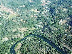
Trail is a census-designated place and unincorporated community in Jackson County, Oregon, United States. Although it is unincorporated, it has a post office with a ZIP code of 97541. Trail lies at the intersection of Oregon Route 227 and Oregon Route 62, just north of Shady Cove and west of Lost Creek Lake, which is a reservoir of the Rogue River. Trail is located around the mouth of Trail Creek at the Rogue River.
Contents
Map of Trail, OR, USA
Climate
This region experiences warm (but not hot) and dry summers, with no average monthly temperatures above 71.6 °F. According to the Köppen Climate Classification system, Trail has a warm-summer Mediterranean climate, abbreviated "Csb" on climate maps.
References
Trail, Oregon Wikipedia(Text) CC BY-SA