
Transit type Streetcar Annual ridership 100,037,500 (2013) | Number of lines 11 | |
 | ||
Number of stations 685 stops, including 8 shared with the subway (all others but one are street-level stops) Daily ridership 291,000 (avg. weekday,Q2 2014) | ||
The Toronto streetcar system is a network of eleven streetcar routes in Toronto, Ontario, Canada, operated by the Toronto Transit Commission (TTC). It is both the largest and busiest light-rail system in North America as well as the largest tramway in the Americas in terms of ridership, number of cars, and track length. The network is concentrated primarily in Downtown Toronto and in proximity to the city's waterfront. Much of the streetcar route network dates to the 19th century. Most of Toronto's streetcar routes operate on street trackage shared with vehicular traffic, and streetcars stop on demand at frequent stops like buses. Some routes operate wholly or partly within their own rights-of-way, and stop on demand at frequent stops.
Contents
- Early history 18611945
- Abandonment plans 19451989
- Scarborough RT 1985present
- Expansion period 19892000
- 21st century 2001present
- Incidents
- Routes
- Route numbers
- Dedicated rights of way
- Transit City
- Other proposals
- Toronto Street Railway
- Toronto Railway Company
- Toronto Civic Railways
- Rolling stock
- Streetcars purchased by the TTC
- Winter operational issues
- Track gauge
- Pre TTC
- Dedicated station
- Loops
- Carhouses
- Operator training
- Blacksmith
- References
There are underground connections between streetcars and the subway at St. Clair West, Spadina, and Union stations, and streetcars enter St. Clair, Dundas West, Bathurst, Broadview, and Main Street stations at street level. At the eight downtown stations, excepting Union, from Queen's Park to College on Line 1 Yonge–University, streetcars stop on the street outside the station entrances.
Toronto's streetcars provide most of the downtown core's surface transit service. Four of the TTC's five most heavily used surface routes are streetcar routes. In 2013, ridership on the streetcar system totalled more than 100 million.
Early history (1861–1945)
In 1861, the City of Toronto (City) issued a thirty-year transit franchise (Resolution 14, By-law 353) for a horse-drawn street railway, after the Williams Omnibus Bus Line had become heavily loaded. Alexander Easton's Toronto Street Railway (TSR) opened the first street railway line in Canada on September 11, 1861, operating from Yorkville Town Hall to the St. Lawrence Market. At the end of the TSR franchise, the City government ran the railway for eight months, but ended up granting a new thirty-year franchise to the Toronto Railway Company (TRC) in 1891. The TRC was the first operator of horseless streetcars in Toronto. The first electric car ran on August 15, 1892, and the last horse car ran on August 31, 1894, to meet franchise requirements.
There came to be problems with interpretation of the franchise terms for the City. By 1912, the city limits had extended significantly, with the annexation of communities to the north (1912: North Toronto) and the east (1908: Town of East Toronto) and the west (1909: the City of West Toronto—The Junction). After many attempts to force the TRC to serve these areas, the City created its own street railway operation, the Toronto Civic Railways to do so, and built several routes. Repeated court battles forced the TRC to build new cars, but they were of old design. When the TRC franchise ended in 1921, the Toronto Transportation Commission (TTC) was created, combining the city-operated Toronto Civic Railways lines into its new network.
The TTC began in 1921 as solely a streetcar operation, with the bulk of the routes acquired from the private TRC and merged with the publicly operated Toronto Civic Railways.
In 1923, the TTC took over the Lambton, Davenport and Weston routes of the Toronto Suburban Railway (TSR) and integrated them into the streetcar system.
In 1925, routes were operated on behalf of the Township of York (as Township of York Railway), but the TTC was contracted to operate them. One of these routes was the former TSR Weston route.
In 1927, the TTC became the operator of three radial lines of the former Toronto and York Radial Railway. The TTC connected these lines to the streetcar system in order to share equipment and facilities, such as carhouses, but the radials had their own separate management within the TTC's Radial Department. The last TTC-operated radial (North Yonge Railways) closed in 1948.
Abandonment plans (1945–1989)
After the Second World War, many cities across North America and Europe began to eliminate their streetcar systems in favour of buses. During the 1950s, the TTC continued to invest in streetcars and the TTC took advantage of other cities' streetcar removals by purchasing extra PCC cars from Cleveland, Birmingham, Kansas City, and Cincinnati.
In 1966, the TTC announced plans to eliminate all streetcar routes by 1980. Streetcars were considered out of date, and their elimination in almost all other cities made it hard to buy new vehicles and maintain the existing ones. Metro Toronto chair William Allen claimed in 1966 that "streetcars are as obsolete as the horse and buggy". Many streetcars were removed from service when Line 2 Bloor–Danforth opened in February 1966.
The plan to abolish the streetcar system was strongly opposed by many in the city, and a group named "Streetcars for Toronto" was formed to work against the plan. The group was led by professor Andrew Biemiller and transit advocate Steve Munro. It had the support of city councillors William Kilbourn and Paul Pickett, and urban advocate Jane Jacobs. Streetcars for Toronto presented the TTC board with a report that found retaining the streetcar fleet would in the long run be cheaper than converting to buses. This combined with a strong public preference for streetcars over buses changed the decision of the TTC board.
The TTC then maintained most of its existing network, purchasing new custom-designed Canadian Light Rail Vehicles (CLRV) and Articulated Light Rail Vehicles (ALRV). It also continued to rebuild and maintain the existing fleet of PCC (Presidents' Conference Committee) streetcars until they were no longer roadworthy.
The busiest north–south and east–west routes were replaced respectively by Yonge–University and Bloor–Danforth subway lines, and the northernmost streetcar lines, including the North Yonge and Oakwood routes, were replaced by trolley buses (and later by diesel buses).
Two other lines that operated north of St. Clair Avenue were abandoned for other reasons: the Rogers Road route was abandoned to free up streetcars for expanded service on other routes, and the Mount Pleasant route was removed because of complaints from drivers that streetcars slowed their cars down and because the track was aging and would have needed to be replaced.
Scarborough RT (1985–present)
Early proposals for Scarborough Rapid Transit (RT) line (now Line 3 Scarborough) were for operation with streetcars on a private right-of-way, but the plans were changed when the Ontario government persuaded the TTC and the borough of Scarborough to buy its Intermediate Capacity Transit System (ICTS) rapid transit trains instead. Another proposed streetcar/rapid transit line from Kipling station was abandoned, but the ghost platform at the bus level is a hint of a streetcar line.
Expansion period (1989–2000)
The TTC returned to building new streetcar routes in 1989. The first new line was route 604 Harbourfront, starting from Union Station, travelling underneath Bay Street and rising to a dedicated centre median on Queen's Quay (along the edge of Lake Ontario) to the foot of Spadina Avenue. This route was lengthened northward along Spadina Avenue in 1997, continuing to travel in a dedicated right-of-way in the centre of the street, and ending in an underground terminal at Spadina Station. At this time, the route was renamed 510 Spadina to fit with the numbering scheme of the other streetcar routes. This new streetcar service replaced the former route 77 Spadina bus, and since 1997 has provided the main north-south transit service through Toronto's Chinatown and the western boundary of University of Toronto's main campus. The tracks along Queen's Quay were extended to Bathurst Street in 2000 to connect to the existing Bathurst route, providing for a new 509 Harbourfront route from Union Station to the refurbished Exhibition Loop at the Exhibition grounds, where the Canadian National Exhibition is held.
21st century (2001–present)
By 2003, two-thirds of the city's streetcar tracks were in poor condition as the older track was poorly built using unwelded rail attached to untreated wooden ties lying on loose gravel. The result was street trackage falling apart quickly requiring digging up everything after 10–15 years. Thus, the TTC started to rebuild tracks using a different technique. With the new technique, concrete is poured over compacted gravel, and the ties are placed in another bed of concrete, which is topped by more concrete to embed rail clips and rubber-encased rails. The resulting rail is more stable and quieter with less vibration. The new tracks are expected to last 25 years after which only the top concrete layer needs to be removed in order to replace worn rails.
Route 512 St. Clair was rebuilt to restore a separated right-of-way similar to that of the route 510 on Spadina Avenue, to increase service reliability and was completed on June 30, 2010.
On December 19, 2010, 504 King streetcar service returned to Roncesvalles Avenue after the street was rebuilt to a new design which provided a widened sidewalk "bumpout" at each stop to allow riders to board a streetcar directly from the curb. When no streetcar is present, cyclists may ride over the bumpout as it is doubles as part of a bike lane.
In April 2012, construction began on the 700-metre (2,300 ft) Cherry Street streetcar line (later designated as 514 Cherry), which will run in a dedicated right-of-way on Sumach and Cherry Streets from King Street to the railway corridor south of Mill Street, serving West Don Lands and the Distillery District.
On October 12, 2014, streetcar service resumed on 509 Harbourfront route after the street was rebuilt to a new design that replaced the eastbound auto lanes with parkland from Spadina Avenue to York Street. Thus, streetcars since then run on a roadside right-of-way immediately adjacent to a park on its southern edge.
The Toronto Transit Commission eliminated all Sunday stops on June 7, 2015, as these stops slowed down streetcars making it more difficult to meet scheduled stops. Sunday stops, which served Christian churches, were deemed unfair to non-Christian places of worship, which never had the equivalent of a Sunday stop. Toronto created Sunday stops in the 1920s along its streetcar routes to help worshippers get to church on Sunday.
On November 22, 2015, the TTC started to operate its new fleet of Flexity streetcars from its new Leslie Barns maintenance and storage facility.
On December 14, 2015, the TTC introduced Presto, proof-of-payment and all door loading for all streetcars on all routes. All streetcar passengers are required to carry proof that they have paid their fares such as a validated TTC ticket, paper transfer, pass or Presto card while riding.
With the January 3, 2016 service changes, 510 Spadina became the first wheelchair-accessible streetcar route. All CLRV streetcars were expected to be withdrawn from the route, thus leaving only Flexity streetcars operating. However, CLRV and ALRV streetcars will be used as backup in the event of an insufficient availability of Flexity streetcars.
On June 19, 2016 the TTC launched a new streetcar route operating (alongside route 504 King) along King Street between Dufferin and Sumach, dubbed the 514 Cherry. The route operates every 15 minutes or better, and is partially (and will eventually be fully) operated with the commission's new accessible Flexity streetcars.
Incidents
On December 16, 2010, the TTC suffered its worst accident since the Russell Hill subway crash in 1995. Up to 17 people were sent to hospital with serious but non-life-threatening injuries after a 505 Dundas streetcar heading eastbound collided with a Greyhound bus at Dundas and River Streets.
Routes
Based on 2013 statistics, the TTC operated 304.6 kilometres (189.3 mi) of routes on 82 kilometres (51 mi) streetcar network (double or single track) throughout Toronto. There are 11 regular streetcar routes, with the newest – 514 Cherry – launching on June 18, 2016:
Route numbers
Until 1980, streetcar routes did not have numbers. When the CLRVs were introduced, the TTC assigned route numbers in the 500 series because the signs on the front of the new vehicles were not large enough to display both the route name and destination. Streetcar-replacement bus services also do not indicate the route name.
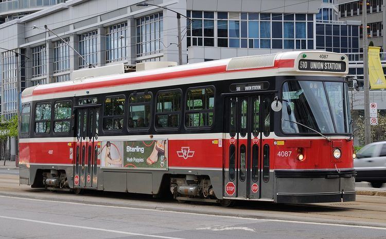
The four streetcar-operated Blue Night Network routes have been assigned 300-series route numbers. The other exception to the 500 series numbering was the Harbourfront LRT streetcar. When introduced in 1990, this route was numbered 604, which was intended to group it with the old numbering scheme for rapid transit routes. In 1996, the TTC overhauled its rapid transit route numbers and stopped trying to market the Harbourfront route as 'rapid transit'. The number was changed to 510. The tracks were later extended in two directions to form the 510 Spadina and 509 Harbourfront routes.
During times when streetcar service on all or a portion of a route has been replaced temporarily by buses (e.g., for track reconstruction, major fire, special event, lack of available streetcars), the replacement bus service is typically identified by the same route number as the corresponding streetcar line.
Dedicated rights-of-way
The majority of streetcar routes operate in mixed traffic, generally reflecting the original track configurations dating from the late 19th and early 20th centuries. However, newer trackage has largely been established within dedicated rights-of-way, in order to allow streetcars to operate with fewer disruptions due to delays caused by automobile traffic. Most of the system's dedicated rights-of-way operate within the median of existing streets, separated from general traffic by raised curbs and controlled by specialized traffic signals at intersections. Queen streetcars have operated on such a right-of-way along the Queensway between Humber and Sunnyside loops since 1957. Since the 1990s, dedicated rights-of-way have been opened downtown along Queens Quay, Spadina Avenue, St. Clair Avenue West, and Fleet Street.
Short sections of track also operate in tunnel (to connect with Spadina, Union, and St. Clair West subway stations). The most significant section of underground streetcar trackage is a tunnel underneath Bay Street connecting Queens Quay with Union Station; this section, which is approximately 700 m (2,300 ft) long, includes one intermediate underground station at Bay Street and Queens Quay.
During the late 2000s, the TTC reinstated a separated right-of-way — removed between 1928 and 1935 — on St. Clair Avenue, for the entire 512 St. Clair route. A court decision obtained by local merchants in October 2005 had brought construction to a halt and put the project in doubt; the judicial panel then recused themselves, and the delay for a new decision adversely affected the construction schedule. A new judicial panel decided in February 2006 in favour of the city, and construction resumed in summer 2006. One-third of the St. Clair right-of-way was completed by the end of 2006 and streetcars began using it on February 18, 2007. The portion finished was from St. Clair Station (Yonge Street) to Vaughan Road. The second phase started construction in the summer of 2007 from Dufferin Street to Caledonia Road. Service resumed using the second and third phases on December 20, 2009 extending streetcar service from St. Clair to Earlscourt Loop located just south and west of Lansdowne Avenue. The fourth and final phase from Earlscourt Loop to Gunns Loop (just west of Keele Street) is completed and full streetcar service over the entire route was finally restored on June 30, 2010.
In 2008, the tracks on Fleet Street between Bathurst Street and the Exhibition Loop were converted to a dedicated right-of-way and opened for the 511 Bathurst and the 509 Harbourfront streetcars. Streetcar track and overhead power line were also installed at the Fleet loop, which is located at the Queen's Wharf Lighthouse.
Transit City
The City of Toronto's and the TTC’s Transit City report released on March 16, 2007, proposed creating new light rail lines. These are mainly separate from the streetcar network as the track gauge and vehicle specifications are quite different. Much of the original proposal has since been cancelled, and those that are proceeding are to be included in the subway part of the network.
Other proposals
The following are proposals to expand the streetcar system that were under consideration in 2015:
Toronto Street Railway
Routes marked to City were operating on May 20, 1891, when the Toronto Street Railway Company's franchise expired and operations were taken over by the City of Toronto.
Toronto Railway Company
Routes marked to TTC were operating on September 21, 1921, when the Toronto Railway Company's operations were taken over by the Toronto Transportation Commission.
Toronto Civic Railways
All routes transferred to the Toronto Transportation Commission.
Rolling stock
Hundreds of cars were acquired from the TTCs predecessor companies, including the Toronto Railway Company, Toronto Civic Railways, Toronto & York Radial Railway and Toronto Suburban Railway.
In the 1920s, the TTC purchased new Peter Witt streetcars, and they remained in use into the 1960s. In 1938 the TTC started to operate its first Presidents' Conference Cars (PCC), eventually operating more than any other city in North America. The last of these vehicles was retired from full-time revenue service in the 1990s, after new Canadian Light Rail Vehicles entered service.
On August 31, 2014, the TTC started operating its first Bombardier Flexity Outlook vehicles. Older vehicles will be retired when enough new vehicles are in service.
Streetcars purchased by the TTC
Note that not all numbers within a series were used.
Winter operational issues
The fleet of CLRV and ALRV has experienced operational issues during extreme cold temperatures in early 2015 as doors and brakes fail as moisture in the pneumatic lines freezes. As a result, the TTC will often substitute buses during extreme cold conditions to prevent cars from blocking roads or getting into accidents when brakes fail to deploy. The problem is being resolved with the new Flexity cars which use electronic braking and door operations.
Track gauge
The tracks of Toronto's streetcars and subways are built to the unique track gauge of 4 ft 10 7⁄8 in (1,495 mm), 2 3⁄8 in (60 mm) wider than the usual 4 ft 8 1⁄2 in (1,435 mm) standard gauge, which Line 3 Scarborough uses. According to Steve Munro, TTC gauge is "English carriage gauge".
As wagons were normally built at standard gauge, the streetcar rails were selected to be slightly wider, allowing the wagons to ride on the inside sections of the rail, and the streetcars on the outside. The Williams Omnibus Bus Line changed the gauge of their buses in 1861 to fit this gauge. At the time, track for horsecars was not our modern 'T' rail, but wide and flat, with a raised section on the outside of the rail.
According to the TTC, the City of Toronto feared that the street railway franchise operator, first in 1861, the Toronto Street Railway, then in 1891, the Toronto Railway Company, and in 1921, the TTC, would allow the operation of steam locomotives and freight trains through city streets, as was common practice in Hamilton, Ontario (until the 1950s) and in many US cities, such as New York City and Syracuse, New York.
Standard gauge rails in the streets would have allowed this, but steam railway equipment could not follow the abrupt curves in the streetcar network. Opposition to freight operation in city streets precluded interchange even with adjacent radial lines even after the lines changed to TTC gauge. Electric railway freight cars could negotiate street curves, but freight operations to downtown were still not allowed until the final few years of radial operation by the TTC.
The unique gauge has remained to this day since converting all tracks and vehicles would be expensive and would lack any real benefit anyway. Some proposals for the city's subway system involved using streetcars in the tunnels, possibly having some routes run partially in tunnels and partially on city streets, so the same gauge was used, but the idea was ultimately dropped in the case of dedicated rapid-transit trains.
Besides the Toronto streetcar and subway systems, the Halton County Radial Railway uses the Toronto gauge of 4 ft 10 7⁄8 in (1,495 mm) for its museum streetcar line.
Pre-TTC
Before TTC ownership, however, the streetcar gauge was either 4 ft 10 3⁄4 in (1,492 mm) or 4 ft 11 in (1,499 mm) depending on historical source instead of today's 4 ft 10 7⁄8 in (1,495 mm).
According to Raymond L. Kennedy said: "The street railways were built to the horse car gauge of 4 feet 10 and 3/4 inches. (The TTC changed this to 4 10 7/8 and is still in use today even on the subway.)" James V. Salmon said the "city gauge" was 4 ft 10 3⁄4 in. Both these sources were describing a former streetcar junction at the intersection of Dundas and Keele Streets laid entirely to Toronto streetcar gauge until August, 1912. The junction was used by both the Toronto Suburban Railway and the Toronto Railway Company.
However, Ken Heard, Consultant Museologist, Canadian Museums Association, was reported to say: "One of the terms of these agreements was that the track gauge was to accommodate wagons. As horse car rail was step rail, the horse cars, equipped with iron wheels with flanges on the inside, ran on the outer, or upper step of the rail. Wagon wheels naturally did not have a flange. They were made of wood, with an iron tire. Wagons would use the inner, or lower step of the rail. The upper step of the rail guided the wagons on the track. In order to accommodate this arrangement, the track gauge had to be 4 feet, 11 inches. As the streets themselves were not paved, this arrangement permitted wagons carrying heavy loads a stable roadbed." In support of Heard's statement about the pre-TTC gauge, the Charter of the Toronto Railway Company said "the gauge of system (4 ft. 11 in.) is to be maintained on main lines and extensions thereof".
Dedicated station
Queens Quay is the one standalone underground station that does not connect to the subway. It is located in the tunnel, shared by the 509 Harbourfront and 510 Spadina routes, between Queens Quay West and Union subway station.
Loops
Since all of Toronto's current streetcars are single-ended, turning loops are provided at the normal endpoints of each route and at likely intermediate turnback locations. A routing on-street around one or more city blocks may serve as a loop, but most loops on the system are wholly or partly off-street. Many of these are also interchange points with subway or bus services.
Carhouses
Toronto's streetcars are housed and maintained at various carhouses or "streetcar barns":
Inactive carhouses once part of the TTC's streetcar operations:
Source: The TTC's Active Carhouses
Operator training
A mockup of a CLRV used to train new streetcar operators is located at Hillcrest. The training simulator consists of an operator cab, front steps and part of the front of a streetcar.
In September 2014, Chris Bateman, writing in the Toronto Life magazine, described being allowed to try out the new simulator designed for the Flexity vehicles. It provides an accurate mockup of the driver's cab of the Flexity vehicle, with a wrap-around computer screen that provides a convincing simulcra of Toronto streets. Like an aircraft cockpit simulator, this Flexity simulator provides realistic tactile feedback to the driver-trainee. The trainer can alter the simulated weather, the track friction, and can introduce more simulated vehicles on the simulated roadway, and even have badly behaved pedestrians and vehicles unpredictably block the Flexity's path.
Bateman wrote that the analogue simulator for the CLRVs was being retired.
Operators also train with a real streetcar. Front and rear rollsigns on the vehicle identify it as a training car.
Blacksmith
Given that the TTC's streetcar rolling stock has been ageing, many parts used by the rolling stock are no longer available. The system has a blacksmith who crafts parts and tools used to maintain the fleet. With the introduction of the new Flexity LRVs, this job may become obsolete.