
Town rights 1830 Area 41.3 km² Local time Sunday 5:13 PM | Established 18th century Time zone CET (UTC+1) | |
 | ||
County Tomaszów Mazowiecki County Gmina Tomaszów Mazowiecki (urban gmina) Weather 22°C, Wind W at 16 km/h, 39% Humidity Points of interest Niebieskie Źródła Nature R, Pilica River Skansen, Groty Nagórzyckie, Park linowy nad Pilicą, Adam Hurtownia zoologicz | ||
Tomaszów Mazowiecki [tɔˈmaʂuf mazɔˈvjɛt͡skʲi] is a town in central Poland with 67,159 inhabitants (2004). Situated in the Łódź Voivodeship (since 1999), it was previously part of Piotrków Trybunalski Voivodeship (1975–1998). Tomaszów occupies an area of 41.3 square kilometres (15.9 sq mi) as of 2002.
Contents
- Map of Tomaszow Mazowiecki Poland
- History
- The Holocaust
- Land usage
- Education
- Transportation
- Sulejw Landscape Park
- Zalew Sulejowski
- Konewka Bunkers
- Twin towns Sister cities
- References
Map of Tomaszow Mazowiecki, Poland
The town is situated on the banks of three rivers, the Pilica, Wolbórka, and Czarna Bielina, and is near the Zalew Sulejowski reservoir and the edge of the Puszcza Spalska wilderness area.
History
Tomaszów Mazowiecki was granted the status of an industry and trade settlement (osada fabryczno-handlowa) in 1824, and was designated a city in 1830 during the November Uprising in Congress Poland against the Russian Empire. A year later the Jewish Qahal was founded.
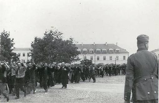
The Holocaust
By 1931 the Jewish population of the city grew to 11,310 inhabitants, or about 30% of the general population of Tomaszów. During the Nazi-Soviet invasion of Poland of 1939 the city was overrun by Nazi Germany. Next month the Great Synagogue was burned to the ground as first on 16 October 1939; the remaining two synagogues were destroyed on 7–14 November. The Ghetto for the imprisonment of 16,500 Polish Jews was created in December 1940, and closed off from the outside in December 1941. Hunger was rampant, followed by the typhus epidemic. In December 1942 some 15,000 Jews were deported aboard Holocaust trains to Treblinka extermination camp. Some 200 Jews from Tomaszów are known to have survived World War II.
Land usage
According to data from 2006, Tomaszów Mazowiecki has an area of 41.3 km2; about 45% of the land is put to agricultural use, 13% is forested, and the city itself covers about 4.03% of the area.
Education
Transportation
Several national and regional routes cross each other in the city:
Sulejów Landscape Park
In the valley of the Pilica river in the south-eastern part of the town there is a unique natural karst spring of water containing calcium salts, that is an object of protection in Niebieskie Źródła Nature Reserve in Sulejów Landscape Park. The origin of the name of the reserve Niebieskie Źródła, that means Blue Springs, comes from the fact that red waves are absorbed by water and only blue and green are reflected from the bottom of the spring, giving that atypical colour. The reserve in situated near the end of Saint Anthony Street (in Polish: ulica świętego Antoniego) that begins in the centre of Tomaszów Mazowiecki, in proximity to the central square, called Kościuszko Square (in Polish: plac Kościuszki).
Zalew Sulejowski
The Zalew Sulejowski is a large reservoir built from 1969–1973 in order to help meet the demand for fresh drinking water in the city of Łódź and the city of Tomaszów Mazowiecki. The actual reservoir is situated on the territory of three gminas: Tomaszów, Piotrków and Wolbórz. It is popular place for water sports, including windsurfing, kayaking and sailing.
Konewka Bunkers
The Konewka Bunkers is a complex of various technical and headquarters buildings, among which is a large bunker capable of protecting a train from an air raid, normally serving as a station to unload the cargo of the train.
Twin towns — Sister cities
Tomaszów Mazowiecki is twinned with: