
Traversed by WYO 22 to SH 33 Elevation 2,570 m | Topo map USGS Teton Pass | |
 | ||
Similar | ||
Wilson wy teton pass jackson hole west bank real estate
Teton Pass is a high mountain pass in the western United States, located at the southern end of the Teton Range of western Wyoming, between the towns of Wilson, Wyoming and Victor, Idaho. The pass provides access from the Jackson Hole valley to the Teton Valley of eastern Idaho, which includes the access route to Grand Targhee Resort through Driggs, Idaho. To the south of the pass, lies the Snake River Range.
Contents
- Wilson wy teton pass jackson hole west bank real estate
- Map of Teton Pass Wyoming 83014 USA
- Teton pass to yellowstone
- References
Map of Teton Pass, Wyoming 83014, USA
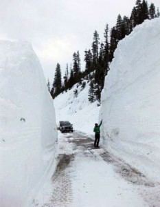
Wyoming Highway 22 crosses the pass and becomes Idaho State Highway 33 at the Idaho border, which continues northwest to Victor, then north to Driggs. The pinnacle of the pass is 8,431 feet (2,570 m) above sea level and is approximately 11 miles (18 km) west of Jackson. The maximum grade on the road is 10% and several avalanche slide paths traverse the road along its length, including Glory Bowl slide area. During the winter months, the road is often closed in the early mornings for avalanche control by the Wyoming Department of Transportation. The area is popular for backcountry skiing, snowboarding, and mountain biking.
The pass is a few miles south of Grand Teton National Park. Parts of the route to the pass are located in the Caribou-Targhee National Forest and the Bridger-Teton National Forest. Wilson, a small town, sits at the base of the east side of the pass. Teton Village and the Jackson Hole Mountain Resort ski area are northeast of the pass.