
Basin countries United Kingdom Islands None | Surface area 0.146 km (0.056 sq mi) Area 15 ha | |
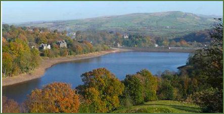 | ||
Toddbrook Reservoir was built in 1831 as a feeder for the Peak Forest Canal. It is sited above the town of Whaley Bridge in the High Peak, Derbyshire. The reservoir is a Site of Special Scientific Interest (SSSI). It provides habitat for herons, ducks and other animals and fish. Also rare mosses and liverworts grow on its shores, particularly short-lived species that grow on seasonally exposed mud. The reservoir is also used for sailing and angling. It hosts many sailing events including DYS (Derbyshire Youth Sailing). The reservoir is owned by the Canal & River Trust and, like Combs Reservoir, is a feeder reservoir for Peak Forest Canal. The feeder runs though Whaley Bridge, and (along with the Combs feed) enters the canal system in a pool close to the transhipments shed at the Whaley Bridge Canal Basin.
Contents
Map of Toddbrook Reservoir, High Peak, UK
The reservoir is fed from a stream named Todd Brook, which has a large catchment area including the shining tor moor land above the reservoir, through which the brook flows. Water enters the reservoir on its north bank through a small waterfall. The first several inches of this do not flow into the reservoir and continue flowing down the reservoir's run off and into the River Goyt. This means that the reservoir often receives little or no inflow during periods where rainfall does not allow the level to exceed this barrier. This often has significant impact on the reservoir's water level, particularly in the summer months.
Dam worksEdit
In the 1980s British Waterways carried out significant repair works to the dam to deal with leaks involving the mining shafts located around the dam. This resulted in a culvert being constructed under the current beach/launching area for the reservoir. A stone marker could be seen on the main beach showing the location of this for many years, but was relocated to the footpath opposite Toddbrook Lodge during access work for the 2009 draining.
It was known that the local coal mining industry had been a challenge for the damn's integrity for many years. The original builders were forced to purchase a block of coal below the damn in situe in order to ensure it's mining did not cause structural issues.
The reservoir was also partially drained in 2009 for re-alignment works on the dam, and again subsequently in 2010.