
Elevation 2,331 m | Prominence 340 m | |
 | ||
Similar Store Knutsholstinden, Nautgardstind, Besshø, Rasletind, Surtningssue | ||
Skarvflyen ved tj rnholstind mai 2005
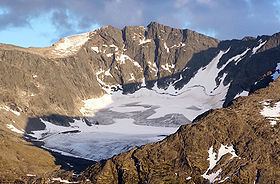
Tjørnholstind (official form on maps: Tjønnholstinden) is a mountain in Vågå, Oppland, Norway and lies in the mountain range Jotunheimen south of the lake Gjende and north of the valley Leirungsdalen. On the northern side is a 400 m vertical drop down to Nordre Tjønnholet, a glacier.
Contents
- Skarvflyen ved tj rnholstind mai 2005
- Map of TjC3B8rnholstind 2683 Tessanden Norway
- The name
- References
Map of Tj%C3%B8rnholstind, 2683 Tessanden, Norway
The mountain has two peaks with a narrow ridge between. The western summit is the highest and the lower eastern summit also has the name Steinflytind and has elevation 2,318 m (7,605 ft).
The mountain and both peaks are easily accessible from both west and east.
The name
The first element is the genitive of the name of the gorge Tjønnholet, the last element is the finite form of tind m 'mountain peak'. The name of the gorge is a compound of tjønn f 'tarn, small lake' and the finite form of hol n 'hole (hollow), gorge'. There are actually two gorges with the name Tjønnholet here: Nørdre Tjønnholet north of the peak - and Søre Tjønnholet south of the peak.