
Languages Puquina. Historical era Pre-Columbian Disestablished 1150 Capital Tiwanaku | Government Not specified Established 300 Today part of Bolivia
Peru
Chile | |
 | ||
The Tiwanaku (Spanish: Tiahuanaco or Tiahuanacu) state was a Pre-Columbian polity based in city of Tiwanaku in western Bolivia that extended around Lake Titicaca and into present-day Peru and Chile from 300 to 1150. There are many theories about the type of Tiwanaku state, one opinion is that it was a far-reaching military empire, while other theory is that it was the center for regional religious pilgrimages and llama caravan trade routes without much political authority. The Tiwanaku empire was most likely a result of direct colonization of nearby areas and cultural dominance over more distant areas, where Tiwanaku’s influence was based on religion, culture and trade instead of direct military and political control. The empire was more like a federation of autonomous regional communities for whom Tiwanaku was the center of religion, culture and trade.
Contents
- Rise
- Colonies
- Agriculture
- Collapse
- Religion
- Architecture and art
- Lukurmata
- Relationship with Wari
- References
Tiwanaku is recognized by Andean scholars as one of the most important civilizations prior to the rise of the Inca Empire; it was the ritual and administrative center of a major culture for approximately five hundred years. The ruins of the ancient city of Tiwanaku are located near the south-eastern shore of Lake Titicaca in Tiwanaku Municipality, Ingavi Province, La Paz Department, about 72 km (45 mi) west of La Paz.
Rise
The area around Tiwanaku might have been inhabited as early as 1500 BC as a small agricultural village. By 400 there were several city states around lake Titicaca, among which Tiwanaku gained supremacy. New cult buildings were built, polychrome pottery introduced and a distinctive sculptural style developed. Around 400 a Tiwanaku state in the Titicaca basin began to develop.
Tiwanaku expanded its reach into the Yungas and brought its culture and way of life to many other cultures in Peru, Bolivia, and the people of the Northern regions of Argentina and Chile. It was not exclusively a military or violent culture. In order to expand its reach, Tiwanaku used politics to create colonies, negotiate trade agreements (which made the other cultures rather dependent), and establish state cults. Others were drawn to the Tiwanaku empire due to religious beliefs, as it continued to be an important religious center. On the northern end of the Titicaca basin, locals resisted the Tiwanaku expansion.
Evidence reveals that the bases of some statues were taken from other regions and carried back to the capital city of Tiwanaku, where the stones were placed in a subordinate position to the Gods of the Tiwanaku. They displayed the power that their empire had over others. The empire continued to grow, absorbing other cultures rather than eradicating them. Archaeologists see a noticeable adoption of Tiwanaku ceramics in the cultures that became part of the empire. Tiwanaku gained its power through the trade it implemented among the cities within its empire.
The community grew to urban proportions between 600 and 800, becoming an important regional power in the southern Andes. William H. Isbell states that "Tiahuanaco underwent a dramatic transformation between 600 and 700 that established new monumental standards for civic architecture and greatly increased the resident population." Early estimates figured that the city had covered approximately 6.5 square kilometers at its maximum, with between 15,000 amd 30,000 inhabitants. However, satellite imaging from the late 20th century has caused researchers to dramatically raise their population estimates. They found that the extent of fossilized suka kollus, or irrigated, raised farming plots, across the three primary valleys of Tiwanaku appeared to have the capacity to support a population of between 285,000 and 1,482,000 people.
A few kilometers away were smaller kin-based settlements. Over 450 settlements have been found in the area of Tiwanaku-Taraco-Katari region, including Lukurmata, Qeyakunt, Kirawi, Quiripujo, Waka Kala, Chirpa Pata, Kala Uyuni and Khonko Wankane.
Colonies
Archaeologists such as Paul Goldstein have argued that the Tiwanaku empire expanded outside of the altiplano area and into the Moquegua Valley in Peru. After 750, there is growing Tiwanaku presence at the Chen Chen site and the Omo site complex, where a ceremonial center was built. Excavations at Omo settlements show signs of similar architecture characteristic of Tiwanaku, such as a temple and terraced mound. Evidence of similar types of artificial cranial deformation in burials between the Omo site and the main site of Tiwanaku is also being used for this argument.
Tiwanaku established several colonies as far as 300 km away. One of the better researched is the colony in Moquegua Valley in Peru, which is 150 km from lake Titicaca and flourished between 400 and 1100. This colony was an agricultural and mining center, producing copper and silver. Small colonies were also established in Chile’s Azapa Valley.
Agriculture
Tiwanaku's location between the lake and dry highlands provided key resources of fish, wild birds, plants, and herding grounds for camelids, particularly llamas. Tiwanaku's economy was based on exploiting the resources of the lake Titicaca, herding of llamas and alpacas and organized farming in raised field systems. Llama meat was consumed and potatoes, quinoa, beans and maize grown. Storage of food was important in the uncertain high altitude climate, so technologies for freeze-dried potatoes and sun-dried meat were developed.
The Titicaca Basin is the most productive environment in the area, with predictable and abundant rainfall. The Tiwanaku culture developed expanded farming. To the east, the Altiplano is an area of very dry arid land. The Tiwanaku developed a distinctive farming technique known as "flooded-raised field" agriculture (suka qullu). Such fields were used widely in regional agriculture, together with irrigated fields, pasture, terraced fields and artificial ponds. Water from Katari and Tiwanku rivers was used to water raised fields, that covered up to 130 square km.
Artificially raised planting mounds were separated by shallow canals filled with water. The canals supply moisture for growing crops, but they also absorb heat from solar radiation during the day. This heat is gradually emitted during the bitterly cold nights and provided thermal insulation against the endemic frost in the region. Traces of similar landscape management have been found in the Llanos de Moxos region (Amazonian flood plains of the Moxos). Over time, the canals also were used to farm edible fish. The resulting canal sludge was dredged for fertilizer.
Though labor-intensive, a suka qullu produces impressive yields. While traditional agriculture in the region typically yields 2.4 metric tons of potatoes per hectare, and modern agriculture (with artificial fertilizers and pesticides) yields about 14.5 metric tons per hectare, suka qullu agriculture yields an average of 21 tons per hectare. Modern agricultural researchers have re-introduced the technique of suka qullu. Significantly, the experimental suka qullu fields recreated in the 1980s by University of Chicago´s Alan Kolata and Oswaldo Rivera suffered only a 10% decrease in production following a 1988 freeze that killed 70-90% of the rest of the region's production. Development by the Tiwanaku of this kind of protection against killing frosts in an agrarian civilization was invaluable to their growth.
As the population grew, occupational niches developed, and people began to specialize in certain skills. There was an increase in artisans, who worked in pottery, jewelry and textiles. Like the later Incas, the Tiwanaku had few commercial or market institutions. Instead, the culture relied on elite redistribution. That is, the elites of the empire controlled essentially all economic output, but were expected to provide each commoner with all the resources needed to perform his or her function. Selected occupations include agriculturists, herders, pastoralists, etc. Such separation of occupations was accompanied by hierarchichal stratification within the empire. The elites gained their status by control of the surplus of food obtained from all regions, which they then redistributed among all the people. Control of llama herds became very significant to Tiwanaku. The animals were essential for transporting crops and goods between the center and periphery of the empire. The animals may also have symbolized the distance between the commoners and the elites.
Collapse
Tiwanaku's power continued to grow along with the surplus of food resources until about 950-1000. The decline began at around 1000 and was complete by 1150. There is evidence of gradual decline in population, as well as destruction of some monuments. The most likely explanation is the change in weather patterns, which reduced ability to grow food and sustain the large populations as the groundwater levels fell and raised-field system collapsed. It’s estimated that the water level in the lake dropped by as much as 12-17 meters. A dramatic shift in climate occurred, as is typical for the region.
A significant drop in precipitation occurred in the Titicaca Basin, and some archaeologists suggest a great drought occurred. As the rainfall failed, many of the cities furthest away from Lake Titicaca began to produce fewer crops to give to the elites. As the surplus of food dropped, the elites' power began to fall. Due to the resiliency of the raised fields, the capital city became the last place to maintain agricultural production. With continued drought, people died or moved elsewhere. In isolated places, some remnants of the Tiwanaku people, such as the Uros, may be direct descendants of the people.
Other archeologists support theory that Tiwanaku fell as a result of uprising, as almost all public and ritual areas show signs of intentional destruction. Monolithic gates, like Gateway of the Sun, were tipped over and broken. By the end of Tiwanaku V period the Putuni complex was burned and food storage jars smashed. This indicates an event of destruction, followed by abandonment of the site. Colonies in Moquegua and on Isla del Sol were also burned around this time.
Beyond the northern frontier of the Tiwanaku state a new power started to emerge in the beginning of the 13th century, the Inca Empire. In 1445 Pachacuti Inca Yupanqui (the ninth Inca) began conquest of the Titicaca region. He incorporated and developed what was left from the Tiwanaku patterns of culture, and the Inca officials were superimposed upon the existing local officials. Quechua was made the official language and sun worship the official religion. So the last traces of the Tiwanaku civilization were integrated or abandoned.
Religion
What is known of Tiwanaku religious beliefs is based on archaeological interpretation and some myths, which may have been passed down to the Incas and the Spanish. They seem to have worshipped many gods, perhaps centered on agriculture. One of the most important gods was one that would eventually develop into the Incan God Viracocha, the god of action, shaper of many worlds, and destroyer of many worlds. He created people, with two servants, on a great piece of rock. Then he drew sections on the rock and sent his servants to name the tribes in those areas.
In Tiwanaku, he created the people out of rock and brought life to them through the earth. The Tiwanaku believed that Viracocha created giants to move the massive stones that comprise much of their archaeology, but then grew unhappy with the giants and created a flood to destroy them.
Viracocha is carved into the noted Gateway of the Sun, to overlook his people and lands. The Gateway of the Sun is a monolithic structure of regular, non-monumental size. Its dimensions suggest that other regularly sized buildings existed at the site. It was found at Kalasasaya, but due to the similarity of other gateways found at Pumapunku, it is thought to have been originally part of a series of doorways there. It is recognized for its singular, great frieze. This is thought to represent a main deity figure surrounded by either calendar signs or natural forces for agricultural worship. Along with Viracocha, another statue is in the Gateway of the Sun. This statue is believed to be associated with the weather:
a celestial high god that personified various elements of natural forces intimately associated the productive potential of altiplano ecology: the sun, wind, rain, hail – in brief, a personification of atmospherics that most directly affect agricultural production in either a positive or negative manner
It has twelve faces covered by a solar mask, and at the base thirty running or kneeling figures. Some scientists believe that this statue is a representation of the calendar with twelve months and thirty days in each month.
Other evidence points to a system of ancestor worship at Tiwanaku. The preservation, use, and reconfiguration of mummy bundles and skeletal remains, as with the later Inca, may suggest that this is the case. Later cultures within the area made use of large "above ground burial chambers for the social elite... known as "chullpas". Similar, though smaller, structures were found within the site of Tiwanaku.
Kolata suggests that, like the later Inca, the inhabitants of Tiwanaku may have practiced similar rituals and rites in relation to the dead. The Akapana East Building has evidence of ancestor burial. The human remains at Akapana East seem to be less for show and more for proper burial. The skeletons show many cut marks that were most likely made by defleshing or excarnation after death. The remains were then bundled up and buried rather than left out in the open.
The Tiwanaku conducted human sacrifices on top of a building known as the Akipana. People were disemboweled and torn apart shortly after death and laid out for all to see. It is speculated that this ritual was a form of dedication to the gods. The type of human sacrifice included victims being hacked in pieces, dismembered, exposed to the elements and carnivores before being deposed in trash. Research showed that one man who was sacrificed was not a native to the Titicaca Basin, leaving room to think that sacrifices were most likely of people originally from other societies.
Architecture and art
Tiwanaku monumental architecture is characterized by large stones of exceptional workmanship. In contrast to the masonry style of the later Inca, Tiwanaku stone architecture usually employs rectangular ashlar blocks laid in regular courses. Their monumental structures were frequently fitted with elaborate drainage systems. The drainage systems of the Akapana and Pumapunku structures include conduits composed of red sandstone blocks held together by ternary (copper/arsenic/nickel) bronze architectural cramps. The I-shaped architectural cramps of the Akapana were created by cold hammering of ingots. In contrast, the cramps of the Pumapunku were created by pouring molten metal into I-shaped sockets. The blocks have flat faces that do not need to be fitted upon placement because the grooves make it possible for the blocks to be shifted by ropes into place. The main architectural appeal of the site comes from the carved images and designs on some of these blocks, carved doorways, and giant stone monoliths.
The quarries that supplied the stone blocks for Tiwanaku lie at significant distances from this site. The red sandstone used in this site's structures has been determined by petrographic analysis to come from a quarry 10 kilometers away—a remarkable distance considering that the largest of these stones weighs 131 metric tons. The green andesite stones that were used to create the most elaborate carvings and monoliths originate from the Copacabana peninsula, located across Lake Titicaca. One theory is that these giant andesite stones, which weigh over 40 tons, were transported some 90 kilometers across Lake Titicaca on reed boats, then laboriously dragged another 10 kilometers to the city.
Lukurmata
Lukurmata, located in the Katari valley was the second great city of the Tiwanaku empire. Between 600 and 800 it expanded from 20 hectares to 120 hectares. First established nearly two thousand years ago, it grew to be a major ceremonial center in the Tiwanaku state, a polity that dominated the south-central Andes from 400 to 1200. After the Tiwanaku state collapsed, Lukurmata rapidly declined, becoming once again a small village. The site shows evidence of extensive occupation that antedates the Tiwanakan civilization.
Relationship with Wari
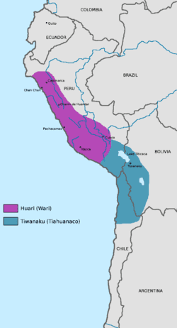
The Tiwanaku shared domination of the Middle Horizon with the Wari culture (based primarily in central and south Peru) although found to have built important sites in the north as well (Cerro Papato ruins). Their culture rose and fell around the same time; it was centered 500 miles north in the southern highlands of Peru. The relationship between the two empires is unknown. Definite interaction between the two is proved by their shared iconography in art. Significant elements of both of these styles (the split eye, trophy heads, and staff-bearing profile figures, for example) seem to have been derived from that of the earlier Pukara culture in the northern Titicaca Basin.
The Tiwanaku created a powerful ideology, using previous Andean icons that were widespread throughout their sphere of influence. They used extensive trade routes and shamanistic art. Tiwanaku art consisted of legible, outlined figures depicted in curvilinear style with a naturalistic manner, while Wari art used the same symbols in a more abstract, rectilinear style with a militaristic style.
Tiwanaku sculpture is comprised typically of blocky, column-like figures with huge, flat square eyes, and detailed with shallow relief carving. They are often holding ritual objects, such as the Ponce Stela or the Bennett Monolith. Some have been found holding severed heads, such as the figure on the Akapana, who possibly represents a puma-shaman. These images suggest the culture practiced ritual human beheading. As additional evidence, headless skeletons have been found under the Akapana.
They also used ceramics and textiles, composed of bright colors and stepped patterns. An important ceramic artifact is the qiru, a drinking cup that was ritually smashed after ceremonies and placed with other goods in burials. As the empire expanded, the style of ceramics changed. The earliest ceramics were "coarsely polished, deeply incised brownware and a burnished polychrome incised ware". Later the Qeya style became popular during the Tiwanaku III phase, "Typified by vessels of a soft, light brown ceramic paste". These ceramics included libation bowls and bulbous-bottom vases.
Examples of textiles are tapestries and tunics. The objects typically depicted herders, effigies, trophy heads, sacrificial victims, and felines. Such small, portable objects of ritual religious meaning were a key to spreading religion and influence from the main site to the satellite centers. They were created in wood, engraved bone, and cloth. They depicted puma and jaguar effigies, incense burners, carved wooden hallucinogenic snuff tablets, and human portrait vessels. Like the Moche, Tiwanaku portraits expressed individual characteristics.