
OS grid reference ST944295 Population 2,056 (2001) | Unitary authority Region South West Sovereign state United Kingdom Local time Saturday 7:45 PM Dialling code 01747 | |
 | ||
Weather 11°C, Wind W at 11 km/h, 83% Humidity | ||
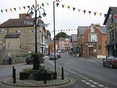
Tisbury is a large village and civil parish approximately 13 miles (21 km) west of Salisbury in the English county of Wiltshire. With a population at the 2011 census of 2,253 it is a centre for communities around the upper River Nadder and Vale of Wardour. The parish includes the hamlets of Upper Chicksgrove and Wardour.
Contents
- Map of Tisbury Salisbury UK
- Prehistory
- History
- 19th century development
- Governance
- Notable people
- Religious sites
- Filmography
- Transport
- References
Map of Tisbury, Salisbury, UK
Tisbury is the largest settlement within the Cranborne Chase and West Wiltshire Downs Area of Outstanding Natural Beauty (larger nearby settlements such as Salisbury and Shaftesbury are just outside it).
Prehistory
The village has some paleoanthropological significance. Evidence of early human activity in the Tisbury area comes from the Middle Gravel at Swanscombe a 400,000-year-old stratum in which skull framents of a young woman was found, the so-called Swanscombe Man. Along with the remains was found several fragments of Pseudodiplocoenia oblonga (also known as Isastraea oblonga), one of four Upper Jurassic species of coral unique to the Upper Portlandian of Tisbury. This indicates that either the group of which Swanscomb Man belonged to traveled to the Tisbury area or were part of a trade network linked to the locality. The coral-bearing chert found at Swanscombe has been interpreted as being intentionally carved to represent the profile of a hominid head, making Tisbury the source of materiel used in what is possibly one of the World's oldest pieces of art.
As in much of the Wiltshire Downs, there is also evidence of Bronze Age settlement. The Tisbury Hoard comprising 114 bronze items, discovered in 2011, is from the 9th to 8th century BC. There are traces of a probable henge monument with some evidence of settlement 3–4000 years ago. To the southeast of the village there is a quite large hill fort. Now known as Castle Ditches this was referred to as Willburge in the charter of 984 A.D. Enclosed within ramparts of the hill fort is a long barrow measuring 60m long, 25m wide and 0.7m high. At that time the village was known as Tisseburi. A stone circle once stood in one of three adjacent fields, one which was known as Lost Stone Field, located near the junction of the Chicksgrove and Chilmark roads. These fields have been joined to form the present Cemetery Field. The last three remaining standing stones, removed in the latter part of the 18th Century now form part of the grotto at Old Wardour.
History
There are known early references between 710 and 716 to Wintra, Abbot of Tisbury and in 759 monks of Tisbury are mentioned in a grant of land to Abbot Ecgnold and his familia (community) at Tisbury Minster. The monastery may have been founded as early as 705. The monastery may have been located near an old cemetery discovered north of Church Street.
The Saxon settlement came into the possession of Shaftesbury Abbey across the county border in Dorset. The administration centre was the monastic grange, still called Abbey Grange Place Farm. Its thatched tithe barn, one of its timbers dated by dendrochronology to 1279, a Grade I listed building, bears the largest thatched roof in England. It is now used as a multi-purpose gallery and arts centre, managed by Messums Wiltshire. The old Wardour Castle lies approximately 2.5 miles (4.0 km) to the southwest of Tisbury.
Some idea of the population of the area in the 14th century can be found by looking at the number assessed as being liable to the poll tax of 1377. Every lay person over the age of 14 years who was not a beggar had to pay a groat (4d) to the Crown. The number of taxpayers in Hatch, East and West (in Tisbury) was 152, and in Tisbury it was 281.
The village's 13th-century prosperity came from the quarries that produced stone for the building of Salisbury Cathedral, and from the wool that supported a local cloth industry. The village suffered a serious setback with the Black Death in the mid-14th century but slowly recovered. To the South-west of the village center is the remains of the village of Wyck, abandoned at some time in the Middle Ages.
On John Speed's map of Wiltshire of 1611, the village's name is recorded as Tilburye: the cartographer or the engraver clearly having mistaken a long s for an l.
19th century development
From 1861 the room above a building near to St John the Baptist parish church, known as The Rank, was used as a glove factory. It employed 36 women and production continued until the early 1970s. In 1873 St. John's Infants' School was built midway up the High Street at the suggestion of Rev. F.E. Hutchinson. It was paid for by Lord Arundell, Sir Michael Shaw-Stewart and Alfred Morrison.
In 1885 Archibald Beckett built a brewery in the village and carried out other improvements, including the construction of a new road through the village, the present day High Street.
Governance
The civil parish elects a parish council. It is in the area of Wiltshire Council unitary authority, which is responsible for all significant local government functions.
The historic parish covered a large area. In 1835 it was divided into three parishes: East Tisbury, West Tisbury and Wardour. In 1927 East Tisbury and Wardour were united as Tisbury civil parish.
An electoral ward with the same name exists. This ward starts in the north at Tisbury and stretches south to end in Donhead St. Mary. The total ward population at the 2011 census was 4,374.
Notable people
Thomas Mayhew (1593-1682), who in 1642 established the first English settlement at Martha's Vineyard in North America, was born in Tisbury. Other people born in Tisbury include the Rev. William Jay (1769-1853, preacher); Etheldred Benett (1776-1845, geologist); Christopher Hinton (1901-1983, nuclear engineer); and Gillian Lewis (stage and television actress).
Sir Matthew Arundell of Wardour Castle, a great landowner and a cousin of Queen Elizabeth, was entombed in the parish church in 1598.
The churchyard also holds the graves of Rudyard Kipling's parents, John Lockwood Kipling and Alice Kipling (née MacDonald), and contains what is reputed to be the second oldest tree in Great Britain, a large yew tree which is believed to be around 4,000 years old. According to one source, "After a long and distinguished artistic career in India, the Kiplings moved to a residence along Hindon Lane which they renamed 'The Gables'. Their famous son visited them here and, whilst working on his novel Kim, his father (his illustrator) used the drawings of one of the pupils from Tisbury Boys' School as the model for the main character." As of early 2013, The Gables, with five bedrooms and an adjoining cricket pitch, was for sale at a price of £950,000.
Edward Doran Webb (1864-1931, ecclesiastical architect) lived in Tisbury, as did Henry Maitland Clark (1929-2012, Northern Irish colonial administrator and politician), Major Derek Cooper (1912-2007, army officer and campaigner for refugees) and John Meade, 7th Earl of Clanwilliam (1919-2009, businessman).
The artist and author John Strickland Goodall lived in Tisbury from 1946 until his death in 1996.
Martin Fleischmann FRS (29 March 1927 – 3 August 2012), a British chemist noted for his work in electrochemistry moved to Tisbury following his retirement as Professor of Electrochemistry at Southampton University. On 23 March 1989 Fleischmann announced at a press conference as that he had achieved "a sustained nuclear fusion reaction", at room temperature which was quickly labeled by the press as cold fusion. Attempts by other scientists failed to reproduce the effects which led to widespread criticism of Fleischmann.
Religious sites
The Church of England parish church of St John the Baptist dates from the 12th century and is Grade I listed. The site may have been the location of a Saxon church, and was the site a 7th-century abbey that was destroyed by the Danes in the 9th century.
Zion Hill, a Congregational chapel, was opened in 1842 and went out of use sometime after 1977; it is now residential accommodation and is Grade II listed.
The Roman Catholic Church of The Sacred Heart was built in 1898 with support from the Arundells of Wardour.
A Methodist chapel was built on the High Street in 1902.
Filmography
Some scenes in the 2009 film Morris: A Life with Bells On were filmed in Tisbury, including at the Tisbury Sports Centre and other scenes were filmed at the nearby Compasses Inn at Lower Chicksgrove.
Scenes of the fictional Locksley Castle from the film Robin Hood:Prince of Thieves were shot at Old Wardour Castle.
Transport
Tisbury railway station is on the West of England Main Line, placing its residents within commuting distance of London. The village is 2.5 miles (4.0 km) from the A303 trunk road linking Andover with the West Country.