
Opened 12 September 2015 Construction started June 2011 | Total length 524 m Location Portland | |
 | ||
Official name Tilikum Crossing, Bridge of the People Address Tilikum Crossing, Bridge of the People, Tilikum Crossing, Portland, OR 97201, USA Similar | ||
Tilikum crossing bridge of the people
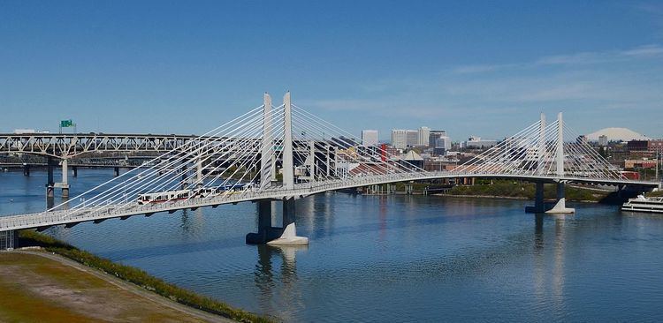
Tilikum Crossing, Bridge of the People is a cable-stayed bridge across the Willamette River in Portland, Oregon, United States. It was designed by TriMet, the Portland metropolitan area's regional transit authority, for its MAX Orange Line light rail passenger trains. The bridge also serves city buses and the Portland Streetcar, as well as bicycles, pedestrians, and emergency vehicles. Private cars and trucks are not permitted on the bridge. It is the first major bridge in the U.S. that was designed to allow access to transit vehicles, cyclists and pedestrians but not cars.
Contents
- Tilikum crossing bridge of the people
- Portland s spirit of innovation tilikum crossing
- Route and function
- Design
- Lighting
- History
- Construction
- Naming
- Inauguration
- References
Construction began in 2011, and the bridge was officially opened on September 12, 2015. In homage to Native American civilizations, the bridge was named after the local Chinook word for people. The Tilikum Crossing was the first new bridge to be opened across the Willamette River in the Portland metropolitan area since 1973.
Portland s spirit of innovation tilikum crossing
Route and function
Tilikum Crossing has its western terminus in the city's South Waterfront area, and stretches across the river to the Central Eastside district. In the 21st century, these two industrial zones have been evolving into mixed residential and commercial neighborhoods, and new transit accommodations are required by the growing populations. Both districts, however, are limited by antiquated road infrastructure that was deemed incapable of handling the increased traffic that could be expected from a conventional automobile bridge. The primary rationale for the bridge was thus "first and foremost as a conduit for a light-rail line."
The bridge is south of, and approximately parallel to, the Marquam Bridge. The west "landing" is midway between the Marquam and Ross Island Bridges, and the east landing is just north of Southeast Caruthers Street, with the east approach viaduct reaching the surface at the west end of Sherman Street, which the tracks follow to a new Oregon Museum of Science and Industry (OMSI) MAX station located near an existing Portland Streetcar station and the Oregon Rail Heritage Center.
Although the planned MAX Orange Line was the impetus for construction of the bridge, the structure also carries TriMet buses, the Portland Streetcar Loop Service and emergency vehicles, and is open for public use by bicyclists and pedestrians. Use by private motor vehicles (except emergency vehicles) is not permitted. Rerouting of TriMet bus routes onto the new bridge from more-congested crossings will shorten the travel time for riders on those routes. Bike and pedestrian paths line both sides of the bridge and are 14 feet (4.3 m) wide. The bridge connects a MAX station at OMSI on the east side of the river with a new OHSU/South Waterfront Campus MAX station on the west side. OHSU is the city's largest employer, while OMSI is one of the city's largest tourist and educational venues, and the new bridge facilitates the connection of both to the regional MAX light rail system. The Orange Line continues south from OMSI to Milwaukie and northern Oak Grove and north from South Waterfront into downtown Portland.
Two bus lines moved to the new bridge from the Ross Island Bridge on September 13, 2015: Lines 9-Powell and 17-Holgate/Broadway.
Design
City planners initially focused on three designs: cable-stayed, wave-frame girder, and through arch, but the design committee eventually recommended a hybrid suspension/cable-stayed design by architect, Miguel Rosales. Despite the recommendation, TriMet chose a cable-stayed option by MacDonald Architects in order to reduce cost. MacDonald had previously designed the similar Eastern span replacement of the San Francisco–Oakland Bay Bridge.
T.Y. Lin International (TYLI), Engineer of Record on the Tilikum Crossing project, designed the distinctive, 180-foot-tall, pentagonal shaped stay-cable towers as the bridge’s focal point. The 1,720-foot-long bridge also features two landside piers and two in-water piers. The 780-foot-long main span deck is separated into a 31-foot-wide transitway between the tower legs to accommodate two lanes of track and two flanking multi-use paths for pedestrians and cyclists.
Cable saddles were incorporated in TYLI’s bridge design to allow for more slender, solid towers and a cleaner bridge profile. Tilikum Crossing is the first bridge in the U.S. to use the Freyssinet multi-tube saddle design, which allows each cable to run continuously from the deck, through the top of the tower and back down to the other side. Approximately 3.5 miles of cables run continuously through the tower saddle, instead of terminating in each tower.
Lighting
A light art aesthetic lighting system, designed by installation artists Anna Valentina Murch and Doug Hollis, alters the bridge’s lighting effects based on the Willamette’s speed, depth, and water temperature. It uses 178 LED modules to illuminate the cables, towers, and underside of the deck. The USGS environmental data is translated by specialized software to a processor that issues cues programmed for each of the changing conditions. The base color is determined by the water's temperature. The timing and intensity of the base color's changes, moving the light across the bridge, are determined by the river's speed. A secondary color pattern is determined by the river's depth, that changes on the two towers and the suspension cables.
History
The alignment was finalized in 2008, after consideration of several alternative alignments. However, some studies and public discussion had taken place more than a decade earlier, when a MAX light rail line to Milwaukie was part of the so-called "South/North MAX" project (Vancouver–Downtown Portland–Milwaukie–Clackamas Town Center) for which voters in the Metro district approved funding in November 1994. Alternatives had included routing the proposed MAX line across the existing Hawthorne Bridge and, instead, building a new bridge on any of various alternative alignments, one of which was known as the "Caruthers Street bridge" alignment or simply "Caruthers Bridge" because its east end would roughly align with S.E. Caruthers Street. The "South/North" MAX project was ultimately mothballed after Clark County voters rejected funding their share of the project in 1995 and subsequent efforts by TriMet and Portland officials to secure funding for a scaled-back Vancouver–Portland–Milwaukie MAX line were unsuccessful. However, the planning undertaken during that period included finalizing, by 1998, the choice of a 'Caruthers' alignment for the planned new bridge. After planning for a light rail line to Milwaukie resumed, in the early 2000s, the bridge-alignment question was revisited, with a Hawthorne Bridge routing again among the options (because of its much lower cost) but with a new bridge having the widest support. In 2008, the earlier bridge routing choice was reaffirmed, except with the planned west end positioned farther south than previously, so as to better serve the then-new South Waterfront district, where major redevelopment had occurred in the several years since the "South/North" project's planning was undertaken.
Construction
The project received required approval from both the Portland and Milwaukie city councils and Oregon's Metro regional governmental agency in 2008. TriMet approved a $127 million contract to build the bridge in December 2010. Onsite engineering of the TriMet design was handled by the HNTB Corporation with primary contracting performed by Kiewit.
Construction of the bridge was estimated to cost $134.6 million, to be paid for by federal grants, Oregon Lottery revenue and TriMet. Construction of the bridge began in June 2011, with a slow/no wake zone put in place to ensure the safety of river users and bridge construction workers. Beginning in July 2011, an exclusion area around the in-water bridge construction site went into effect. Construction of the bridge itself was scheduled for completion in 2014, followed by several months of work to install tracks and other infrastructure across the bridge.
As part of testing the signaling and overhead catenary systems, MAX and streetcar vehicles first ran across the bridge under their own power on January 21, 2015.
Naming
TriMet selected the name of the bridge in April 2014 from a list of four finalists chosen by the public. Tilikum is a Chinook Jargon word meaning people, tribe, or family, and the name is intended to honor the Multnomah, Cascade, Clackamas, and other Chinookan peoples who lived in the area as long as 14,000 years ago. The Tilikum name also references the pervasive use of Chinook Jargon in Portland’s first half century in the frequent trade interactions between pioneers and Native Americans. Before being named, the still-uncompleted bridge had usually been referred to as the Portland–Milwaukie Light Rail Bridge, or as Caruthers Crossing due to its proximity to Caruthers Street.
After the public was invited to suggest names for the bridge in the summer of 2013, the favorite choice of participants was, by an overwhelming margin, street musician Kirk Reeves. However, TriMet rejected the nomination of the recently deceased performer, and in January 2014, it chose four other, less popular finalists:
Public commentary on the names was accepted until March 1 and TriMet chose the final name, Tilikum Crossing, Bridge of the People in April, using the spelling preferred by the Chinookan peoples.
Inauguration
The crossing opened for general use on September 12, 2015, becoming the first new bridge built across the river in the Portland metropolitan area since 1973. The first public access to the bridge was given on August 9, 2015, in the morning for the 20th annual Providence Bridge Pedal and in the afternoon with a three-hour period in which the bridge was open to everyone.