
Carries US 26 Maintained by ODOT Address Portland, OR 97239, USA Height 37 m Bridge type Cantilever bridge | Opened 21 December 1926 Clearance below 37 m | |
 | ||
Similar Marquam Bridge, Sellwood Bridge, Willamette River, Morrison Bridge, Hawthorne Bridge | ||
Workers fall 40 ft on ross island bridge
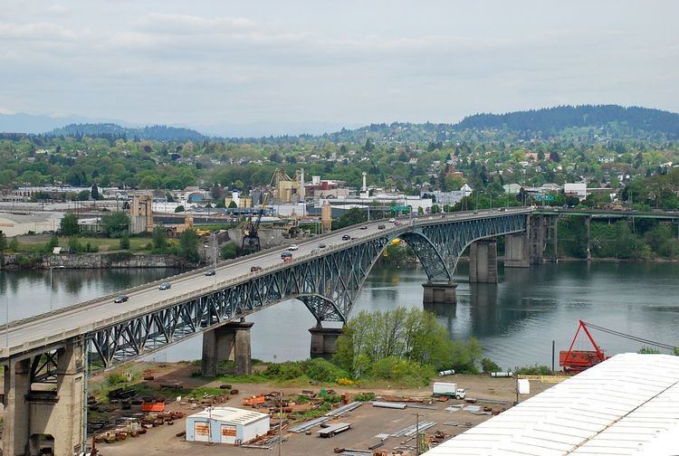
The Ross Island Bridge is a cantilever truss bridge that spans the Willamette River in Portland, Oregon. It carries U.S. Route 26 (Mount Hood Highway) across the river between southwest and southeast Portland. The bridge opened in 1926 and was designed by Gustav Lindenthal and honors Oregon pioneer Sherry Ross. It is named for its proximity to Ross Island. Although it looks like a deck arch bridge, it is a cantilever deck truss bridge, a rare type in Oregon.
Contents
Workers fall 40 ft on ross island bridge
History and description
The bridge was part of the unprecedented period of bridge building in Portland during the 1920s. It was opened on December 21, 1926, and cost $2 million to construct. The bridge was designed by famed engineer Gustav Lindenthal.
The bridge is named for its location close to Ross Island, an island in the Willamette River which measures about one-and-a-half by one miles. The bridge is about 800 feet (250 m) north of the island and does not connect with, nor does it provide access to, Ross Island. There is a pedestrian walkway on the north side of the bridge, with no barrier between the sidewalk and the westbound right lane.
The bridge's girders were originally painted black, but in 1955–56 they were repainted green. In 1961, Portland architect Lewis Crutcher suggested repainting all of Portland's downtown-area bridges from black into different colors, and the proposal also included changing the Ross Island Bridge's color to blue. The proposal was approved by the Multnomah County Commission, and repainting of the Ross Island Bridge was carried out in the summer of 1965. The bridge's color remains blue today, specifically "phthalo blue".
During the Great Depression, the bank of the Willamette near the Ross Island Bridge became the site of a Hooverville.
In 1976, ownership was transferred from Multnomah County to the Oregon Department of Transportation. In 2000–2001 the bridge underwent a $12.5 million renovation in which the deck was replaced, the railings were replaced and upgraded, and the drainage system and lighting were improved. During this renovation, lead paint was discovered, causing some delays and cost overruns.
West approach
The west end of the bridge has a full interchange with Naito Parkway (Oregon Route 10, Pacific Highway West), as well as access to and from Arthur Street, which carries US 26 towards Interstate 405. (Until around 2005, US 26 went north on Naito Parkway and through the south side of downtown Portland.) Access is also provided to and from the north end of Oregon Route 43 (Macadam Avenue - Oswego Highway), which runs next to Interstate 5 as frontage roads, and allows for access to and from I-5 via slip ramps and U-turns.
The pedestrian walkway comes off the north side parallel to the ramp to Kelly Avenue (leading to Arthur Street), running to the intersection of Kelly Avenue and Porter Street.
East approach
At the east end of the bridge, US 26 becomes Powell Boulevard as it passes over Oregon Route 99E (Pacific Highway East). Route 99E is a high-speed arterial road, built to near-freeway standards; just to the north it passes over a railroad on the twin Martin Luther King, Jr. Viaduct and Grand Avenue Viaduct. There is a direct ramp from US 26 east to Route 99E south, but no northbound access. Likewise, there is access from Route 99E north to the bridge (via Woodward Street and 8th Avenue), but traffic from Route 99E south must exit at Mill Street, about 1/2 mile (1 km) to the north, and head down Division Street, 11th Avenue and Milwaukie Avenue to US 26. This same movement is done to reach US 26 east; US 26 west however has direct access to Route 99E north via 9th Avenue and Woodward Street. A fourth direct ramp runs from Route 99E north to US 26 east.
The pedestrian walkway simply becomes the north sidewalk of Powell Boulevard, a major street.