
- elevation 1,120 m (3,675 ft) Length 1,150 km | - elevation 280.5 m (920 ft) | |
 | ||
- average 2,500 m/s (88,287 cu ft/s) Bridges Ponte Piqueri, Ponte dos Remedios Similar Tietê Bus Terminal, Serra do Mar, Engineer Souza Dias Dam, Ponte Piqueri, Billings Reservoir | ||
Toxic foam chokes out tiet river in brazil
The Tietê River (Portuguese, Rio Tietê) is a Brazilian river in the state of São Paulo.
Contents
- Toxic foam chokes out tiet river in brazil
- Map of TietC3AA River State of SC3A3o Paulo Brazil
- Area of influenceEdit
- Navigation on the waterway Tiet ParanEdit
- Pollution and environmental degradationEdit
- The Tiet projectEdit
- FloodingsEdit
- Affluents of the Tiet RiverEdit
- References
Map of Tiet%C3%AA River, State of S%C3%A3o Paulo, Brazil
The source is in Salesópolis in the Serra do Mar, at 1,120 m altitude. Although the source is at most 22 kilometres (14 mi) from the coast, the escarpment of the Serra do Mar forces it to run in the opposite direction, to the interior, going through the state of São Paulo from southeast to northwest till it runs into the artificial lake formed by Eng Souza Dias (Jupiá) Dam on the Paraná River, in the municipality of Três Lagoas, about 50 kilometres (31 mi) from the city of Pereira Barreto.
The name Tietê was registered for the first time on a map published in 1748 by d’Anville. The name signifies "The truthful river", or "truthful waters" in Tupi.
Area of influenceEdit
The Tietê River runs through the metropolitan area of São Paulo City and runs through 1,136 kilometres (706 mi) of the interior of the São Paulo state, up to the municipality of Itapura, into its mouth, the Paraná River, at the border with Mato Grosso do Sul.
Within the city of São Paulo, it runs next to the express highway Marginal Tietê, which, together with the Marginal Pinheiros, makes up the principal road system of the city. It is estimated that 2,000,000 vehicles pass through either one of the two “marginals” per day CET Company for Traffic Engineering.
Not far after leaving the city of São Paulo, the Tietê River turns to the municipality of Santana de Parnaíba at the hydro-electric station of Edgar de Souza and a little bit further the hydroelectric station of Rasgão and between these two the dam of Pirapora do Bom Jesus. Both hydroelectric power stations were constructed by the old São Paulo Tramway, Light and Power Company and have contributed significantly to the energy used in the city of São Paulo.
Navigation on the waterway Tietê-ParanáEdit
In several dams, for instance the Barra Bonita, systems of locks were implemented to make navigation on the river possible. Many barges transport produce of the region at a cost which is lower than road transport. The waterway of the Tietê-Paraná permits navigation over a length of 1,100 kilometres (680 mi) between Conchas on the River Tietê (São Paulo) and São Simão (Goiás), on the Paranaíba River and then, up to ltaipu, attaining 2,400 kilometres (1,500 mi) of waterway. It already moves more than one million metric tons of grains (maize) per year, at an average distance of 700 kilometres (430 mi). If we calculate the loads with a small distance like sand, gravel, and sugarcane, the movement on the River Tietê is approximately 2 million metric tons. (source : DNIT) Of this waterway, about 450 kilometres (280 mi) of the Tietê River is fully navigable
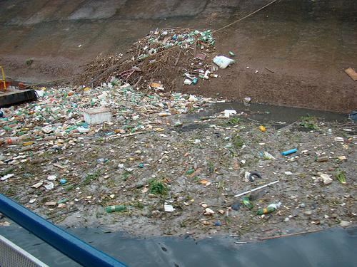
Pollution and environmental degradationEdit
Although the Tiete River is said to be one of the most important rivers economically for the state of São Paulo and for the country, the Tietê River is best known for its environmental problems, especially for the stretch through the city of São Paulo.
The pollution of the Tietê River did not start long ago. Even in the 1960s, the river still had fish in the stretch within the capital. However, the environmental degradation of the Tietê River started subtly in the 1920s with the construction of the Guarapiranga Reservoir, by the Canadian firm São Paulo Tramway, Light and Power Company, for the later generation of electrical energy in the hydroelectric power stations Edgar de Souza and Rasgão, situated in Santana de Parnaíba. This intervention altered the regime of the waters in the capital and was accompanied with some rectification works also by the São Paulo Tramway, Light and Power Company, which left the bed of the river less winding, in the region between Vila Maria and “Freguesia do Ó.”
Even in the 1920s and 1930s, the river was utilised for fishing and sports activities were famous as were the nautical races on the river. During this period boat race clubs were created along the length of the river, such as the Club of the Tietê races and the Espéria, clubs that exist till now.
In September 2010 National Geographic identified the river as the most polluted in Brazil.
The Tietê projectEdit
Overcome by such a heavy popular pressure the governor of São Paulo, elected in October 1990, ordered the Sabesp—a company for basic sanitising of the state, to take it upon them to establish a program to clean up the river. The state at the same time sought help at the Inter American Development Bank—and proposed a project for the recuperation of the river, based on the former studies of SANEGRAN. The difficult task to put an end to the pollution generated by the drains of the Região Metropolitana de São Paulo received the name of Project Tietê. It is not an exclusively governmental project, because it counts on intensive participation of organisations of the civil society. Actually, the Tietê Project is the main environmental recuperation project of the country.
After more than 16 years, the cleaning up of the River Tietê is still far short of desired levels, but encouraging progress has been made. At the end of the 1990s, the capacity of sewage treatment has been expanded: the Sabesp made the expansion of treatment capacity of the Station "Wastewater Treatment Plant in Barueri", 20 kilometres (12 mi) from the municipality of São Paulo and began the "Seasons of the Sewage Treatment of New World Park", at San Miguel and ABC, to treat the rest of the sewage of the city of São Paulo.
At the beginning of the program, the percentage of treated sewage for sewage collected was no more than 20% in the Metropolitan Region of São Paulo. In 2004, this percentage was 63% (including primary and secondary treatment). It is expected that by the end of the program, this rate will reach 90%. Currently, the program is in its third phase. The stain of pollution of the Tietê River, which in the 1990s reached 100 kilometres (62 mi), has been reduced gradually in the course of the works of Tietê Project.
FloodingsEdit
An overflow occurs when the Tietê suddenly receives a large volume of water from its tributaries such as the Aricanduva River, which unloads thousands of cubic meters of water in a few minutes. It takes some time before the water in the Tiete River rises to a new level, during which time the river water spills onto its flanks.
Between 2002 and 2006, the then governor of the state, Geraldo Alckmin, concluded a great project of deepening and "urbanising of the flanks of" the river, a work that started in the decade of the 1980s. This deepening was done notwithstanding the dredging of the river, the deepening was also obtained with explosives, sub aquatic bottom perforation and dredging.