
Length 175 km | ||
 | ||
Main source Curry County, New Mexico4,524 ft (1,379 m) River mouth Randall County, Texas3,471 ft (1,058 m) | ||
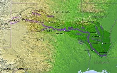
Tierra Blanca Creek is an ephemeral stream about 75 mi (121 km) long, heading in Curry County, New Mexico, flowing east-northeast across northern portions of the Llano Estacado to join Palo Duro Creek to form the Prairie Dog Town Fork Red River southeast of Amarillo, Texas. Overall, Tierra Blanca Creek descends 1,050 ft (320 m) from its headwaters in Eastern New Mexico to its confluence with Palo Duro Creek at the head of Palo Duro Canyon.
Contents
Map of Tierra Blanca Creek, Texas, USA
The creek's water levels are variable, and it is not unusual for some parts of the creek to be reduced to a small trickle or even completely dry during the frequent periods of drought in the desert plateau of the northwestern Texas Panhandle. At the same time, as the sole creek bed draining a large region with frequent violent thunderstorms, it is also the site of significant occasional Flash floods. It's diminishing flow has been attributed to damming and agriculture.
Tierra Blanca Creek was a historically significant as the major running water source for the XIT Ranch, one of the largest cattle ranches in American history. It also contributed to the formation of Palo Duro Canyon, the second largest canyon in the United States.
The Name
Tierra Blanca is Spanish for "white earth". One theory suggests that the name refers to white deposits of Tertiary clay that are found along the sides of the valley. Another theory suggests that it was the exposed traces of white caliche along the valley walls that gave this stream its Spanish name.