
Floor elevation 2,828 ft (862 m) Width 20 mi (32 km) Designated 1976 | Long-axis length 120 mi (190 km) Depth 880 ft (270 m) Phone +1 806-488-2227 | |
 | ||
Similar Panhandle–Plains Historical Museum, Big Bend National Park, Cadillac Ranch, Enchanted Rock, Don Harrington Discovery | ||
Palo duro canyon state park texas official
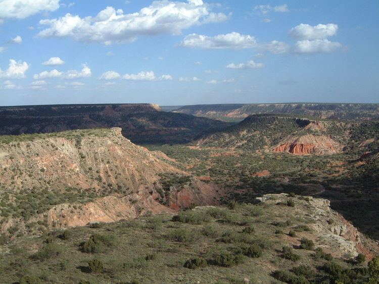
Palo Duro Canyon is a canyon system of the Caprock Escarpment located in the Texas Panhandle near the cities of Amarillo and Canyon. As the second-largest canyon in the United States, it is roughly 120 mi (190 km) long and has an average width of 6 mi (9.7 km), but reaches a width of 20 mi (32 km) at places. Its depth is around 820 ft (250 m), but in some locations, it can increase up to 1,000 ft (300 m). Palo Duro Canyon (from the Spanish meaning "hard wood") has been named "The Grand Canyon of Texas" both for its size and for its dramatic geological features, including the multicolored layers of rock and steep mesa walls similar to those in the Grand Canyon.
Contents
- Palo duro canyon state park texas official
- Palo duro canyon texas scenic drive
- Geology
- History
- In culture
- References
Palo duro canyon texas scenic drive
Geology
The canyon was formed by the Prairie Dog Town Fork of the Red River, which initially winds along the level surface of the Llano Estacado of West Texas, then suddenly and dramatically runs off the Caprock Escarpment. Water erosion over the millennia has shaped the canyon's geological formations.
Notable canyon formations include caves and hoodoos. One of the best-known and the major signature feature of the canyon is the Lighthouse Rock. A multiple-use, six-mile round trip loop trail is dedicated to the formation.
Palo Duro Canyon was downcut by the Prairie Dog Town Fork tributary of the Red River, during the Pleistocene, when the whole region was uplifted. Most of the strata visible in the Canyon were deposited during the Permian and Triassic periods. From oldest to youngest, the formations are:
History
The first evidence of human habitation of the canyon dates back about 10,000–15,000 years, and it is believed to have been continuously inhabited to the present day. Native Americans were attracted to the water of the Prairie Dog Town Fork, Red River, as well as the consequent ample game, edible plants, and protection from weather the canyon provided.
The first European explorers to discover the canyon were members of the Coronado expedition, who visited the canyon in 1541. Apache Indians lived in Palo Duro at the time, but they were later displaced by Comanche and Kiowa tribes, who had the advantage of owning horses brought over by the Spanish. They had contact with traders, called Comancheros, in nearby New Mexico.
A United States military team under Captain Randolph B. Marcy mapped the canyon in 1852 during their search for the headwaters of the Red River. The land remained under American Indian control until a military expedition led by Colonel Ranald S. Mackenzie was sent in 1874 to remove the Indians to reservations in Oklahoma. The Mackenzie expedition captured about 1,200 of the Indians' horses and slaughtered them in nearby Tule Canyon during the Battle of Palo Duro Canyon. The Comanche and Kiowa conceded and left the area.
Soon after, in 1876, Charles Goodnight and a wealthy Ulster Scot named John Adair established the JA Ranch in Palo Duro Canyon. Col. Goodnight helped manage the ranch until 1890. Over the next half century, the canyon remained in private hands, but was an increasingly popular tourist spot for local residents.
The painter Georgia O'Keeffe, who lived in nearby Amarillo and Canyon early in the 20th century, wrote of the Palo Duro: "It is a burning, seething cauldron, filled with dramatic light and color." She made paintings of Palo Duro Canyon between 1916 and 1918, when she was an instructor and head of the art department at West Texas State Normal College.
In 1931, a major landowner signed a two-year contract with the local chamber of commerce to allow public access to the canyon. The upper section of the canyon was purchased by the State of Texas in 1934 and turned into the 20,000-acre (8,100 ha) Palo Duro Canyon State Park. Amarillo is the largest city near Palo Duro Canyon State Park, but the smaller city of Canyon is nearer.
Through 2014, the Texas Department of Transportation is constructing bridges at Palo Duro over Water Crossings 1, 2, and 6 to allow motorists easier access during and after heavy rains. Paving work has been completed at the Juniper Multi-use Area, with the addition of utilities pending. By the spring of 2014, day-use campsites and a group pavilion will be added. Meanwhile, plans have begun to turn the Canoncita Ranch house located on the canyon edge into a research center. The old Comanche Trail used by the Civilian Conservation Corps will be restored to extend from the Mack Dick Group Pavilion to Water Crossing 6, following the base of Fortress Cliffs. Palo Duro also now offers driving tours in a 12-passenger van.
In culture
Palo Duro Canyon is the site of an outdoor historical and musical drama, titled Texas, presented annually each summer by actors, singers, dancers, and artists of the Texas Panhandle region. The spectacle, created by playwright Paul Eliot Green, premiered on July 1, 1966 at the newly constructed Pioneer Amphitheatre in Palo Duro Canyon State Park. It has continued each summer through the present, making Texas "the best-attended outdoor history drama in the nation."
The Symphony No. 3 of American composer Samuel Jones is titled "Palo Duro Canyon." It premiered May 1, 1992 in an outdoor performance at the Palo Duro Canyon State Park's Pioneer Amphitheatre, with James Setapen conducting the Amarillo Symphony (which had commissioned the work). The composer writes: "I wanted the piece ... to conjure up an intuitive awareness of the long movements of time required for the creation of a canyon. I also wanted in some way to pay homage to native Americans, to whom this canyon was a sacred place. And I wanted to capture in music that magical moment which everyone experiences when they first see the flat, treeless High Plains fall dizzyingly away into the colorful vastness of the Palo Duro Canyon itself." A KACV-TV documentary on canyon, composer, and symphony, titled And There Will Be Sounds, was broadcast on PBS stations nationally later that year; and a commercial recording was subsequently released by the Seattle Symphony under the baton of Gerard Schwarz.