
Mouth Bass Strait Mouth elevation 0 | ||
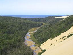 | ||
The Thurra River is a perennial river with no defined major catchment, located in the East Gippsland region of the Australian state of Victoria.
Contents
Map of Thurra River, Tamboon VIC, Australia
Course and features
The Thurra River rises below Mealing Hill in remote country northeast of Cann River and flows generally south through the western edge of the Alfred National Park and through the Croajingolong National Park, before reaching its mouth with Bass Strait, east northeast of Point Hicks in the Shire of East Gippsland. The river descends 311 metres (1,020 ft) over its 71 kilometres (44 mi) course.
The river is traversed by the Princes Highway east of Cann River.
There are Parks Victoria campsites near the Thurra River mouth.
References
Thurra River Wikipedia(Text) CC BY-SA