
 | ||
Thundersnow, also known as a winter thunderstorm or a thundersnowstorm, is an unusual kind of thunderstorm with snow falling as the primary precipitation instead of rain. It typically falls in regions of strong upward motion within the cold sector of an extratropical cyclone. Thermodynamically, it is not different from any other type of thunderstorms, but the top of the cumulonimbus cloud is usually quite low. In addition to snow, graupel, or hail may fall.
Contents
Occurrence
Thundersnow, while relatively rare anywhere, is more common with lake-effect snow in the Great Lakes area of the United States and Canada, the midwestern United States, and the Great Salt Lake. Thundersnow also occurs in Halifax, Nova Scotia, sometimes several times per winter season. Bozeman, Montana also sees thundersnow more often than average with these storms typically occurring in April or May. In the United States, March is the peak month of formation; on average, only 6.4 events are reported per year.
The British Isles and other parts of northwestern Europe occasionally report thunder and lightning during sleet or (usually wet) snow showers during winter and spring. It is also common around Kanazawa and the Sea of Japan, and even around Mount Everest. Low pressure events in the eastern Mediterranean that originate from polar origin cause copious thundersnow occurrences during winter storms, especially over the elevated provinces of Israel and Jordan, including Amman and Jerusalem. When such storms happen at ski areas, these mountains are often evacuated for safety.
Acoustic effects
One unique aspect of thundersnow is that the suspended and deposited snowfall act as an acoustic suppressor of the sound of thunder. The thunder from a typical thunderstorm can be heard many miles away, while the thunder from thundersnow can usually only be heard within a 2–3-mile (3.2–4.8 km) radius from the lightning.
Formation
There are usually three causes of thundersnow:
Lake effect precipitation
Lake effect thundersnow occurs after a cold front or shortwave aloft passes over a body of water. This steepens the thermal lapse rates between the lake temperature and the temperatures aloft. A difference in temperature of 25 °C (45 °F) or more between the lake temperature and the temperature at about 1,500 m (4,900 ft) (the 850 hPa level) usually marks the onset of thundersnow, if surface temperatures are expected to be below freezing. However several factors, including other geographical elements, affect the development of thundersnow.
The primary factor is convective depth. This is the vertical depth in the troposphere that a parcel of air will rise from the ground before it reaches the equilibrium (EQL) level and stops rising. A minimum depth of 1,500 m (4,900 ft) is necessary, and an average depth of 3,000 m (9,800 ft) or more is generally accepted as sufficient. Wind shear is also a significant factor. Linear snow squall bands produce more thundersnow than clustered bands; thus a directional wind shear with a change of less than 12 °C (54 °F) between the ground and 2,000 m (6,600 ft) in height must be in place. However, any change in direction greater than 12 °C (54 °F) through that layer will tear the snow squall apart. A bare minimum fetch of 50 km/h (31 mph) is required so that the air passing over the lake or ocean water will become sufficiently saturated with moisture and will acquire thermal energy from the water.
The last component is the echo top or storm top temperature. This must be at least −30 °C (−22 °F). It is generally accepted that at this temperature there is no longer any super cooled water vapor present in a cloud, but just ice crystals suspended in the air. This allows for the interaction of the ice cloud and graupel pellets within the storm to generate a charge, resulting in lightning and thunder.
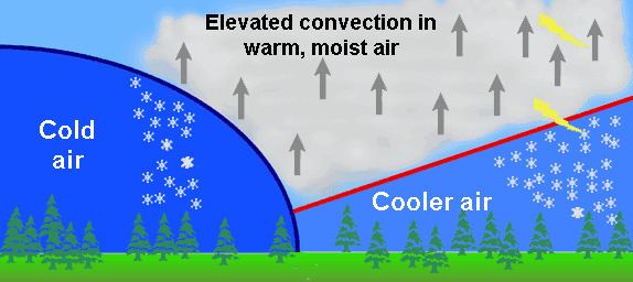
Synoptic forcing
Synoptic snow storms tend to be large and complex, with many possible factors affecting the development of thundersnow. The best location in a storm to find thundersnow is typically in its NorthWest quadrant (in the Northern Hemisphere, based on observations in the Midwestern United States), within what is known as the "comma head" of a mature extratropical cyclone. Thundersnow can also be located underneath the TROWAL, a trough of warm air aloft which shows up in a surface weather analysis as an inverted trough extending backward into the cold sector from the main cyclone. In extreme cases, thunderstorms along the cold front are transported towards the center of the low pressure system and will have their precipitation change to snow or ice, once the cold front becomes a portion of the occluded front. The 1991 Halloween blizzard, Superstorm of 1993, and White Juan are examples of such blizzards featuring thundersnow.
Upslope flow
Similar to the lake effect regime, thundersnow is usually witnessed in terrain in the cold sector of an extratropical cyclone when a shortwave aloft moves into the region. The shortwave will steepen the local lapse rates, allowing for a greater possibility of both heavy snow at elevations where it is near or below freezing, and occasionally thundersnow.
Hazards
Thundersnow produces heavy snowfall rates in the range of 5 to 10 cm (2 to 4 in) per hour. Snowfall of this intensity may limit visibilities severely, even during light wind conditions. However, thundersnow is often a part of a severe winter storm or blizzard. Winds of above tropical storm force are frequent with thundersnow. As a result, visibilities in thundersnow are frequently under 400 m (1⁄4 mi). Additionally, such wind creates extreme wind chills and may result in frostbite. Finally, there is a greater likelihood that thundersnow lightning will have a positive polarity which has greater destructive potential than negatively charged (typical) lightning.