
Length 15.3 km | ||
 | ||
east end: Highway 11 / Highway 17 | ||
The Thunder Bay Expressway is a four-lane highway with signalized intersections running on the western edge of Thunder Bay, in the Canadian province of Ontario. The route carries portions of Highway 61 as well as the concurrency of Highway 11 and Highway 17 around the city, from south of Arthur Street to Highway 527 northeast of it.
Contents
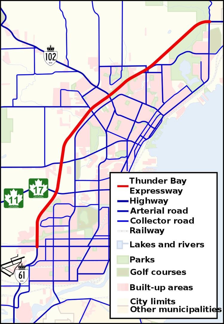
Map of Thunder Bay Expy, Thunder Bay, ON, Canada
The route was built in the late 1960s, opening between mid-1967 and late 1970. The old routes of Highway 11/17 and Highway 61 through Thunder Bay were redesignated as Highway 11B/17B and Highway 61B. Work is now ongoing to twin Highway 11/17 northeast to Nipigon.
Route description
The Thunder Bay Expressway has the unsigned designation of Highway 7250 and forms the southernmost portion of the Terry Fox Courage Highway, which continues east to Nipigon along the Trans-Canada Highway. Between Arthur Street and the Harbour Expressway, it shares a designation with Highway 61, while between there and the eastern terminus at Hodder Avenue, it shares a designation with Highway 11 and 17, a portion of the Trans-Canada Highway.
The entire route is four lanes and undivided, with an exception between Balsam Street and Hodder Avenue where the route is twinned. Its intersections are all at-grade. Plans to entirely twin the highway and build interchanges were abandoned in the 1990s. The province of Ontario announced funding to twin the Trans-Canada Highway from Thunder Bay to Nipigon, which has resulted in the first, local highway interchange at the intersection of Hodder Avenue, and highways 11 and 17.
The highway runs along the western edge of Thunder Bay south and bisects the northwest portion of Thunder Bay north. The bulk of its traffic is local but it is also an important route in the Trans-Canada highway network.
History
In 1963, Charles MacNaughton, minister of the Department of Highways, announced plans for the Lakehead Expressway to be built on the western edge of the twin cities of Port Arthur and Fort William (which amalgamated in 1970 to form Thunder Bay). Work began in August 1965, with a contract for a 5 kilometres (3 mi) section of divided highway on the west side of the twin cities. Plans called for a 28.2 kilometres (17.5 mi) at-grade expressway from South of Arthur Street to meet Highway 11 and Highway 17 northeast of the cities. The first section of the expressway opened on August 29, 1967, connecting Oliver Road (then part of Highway 130) and Golf Links Road with Dawson Road (Highway 102). By mid- to late 1969, the route had been extended to Highway 527 northeast of the twin cities and to Highway 11 and Highway 17 (Arthur Street) at the Harbour Expressway. By late 1970, the route had been extended southward from Arthur Street to Neebing Avenue / Walsh Street West. At this time, Highway 11/17 and Highway 61 were rerouted along the completed expressway. The old routes through Thunder Bay were redesignated as Highway 11B/17B and Highway 61B.
Major intersections
The following table lists the major junctions along Thunder Bay Expressway, as noted by the Ministry of Transportation of Ontario. The entire route is located in Thunder Bay. All exits are unnumbered.