
Elevation 6,858 ft (2,090 m) Isolation 12.8 mi (20.6 km) First ascent 1929 | Prominence 4,490 ft (1,369 m) Topo map Whitehorse Mountain | |
 | ||
Similar Whitehorse Mountain, Mount Pugh, Sloan Peak, Vesper Peak, Del Campo Peak | ||
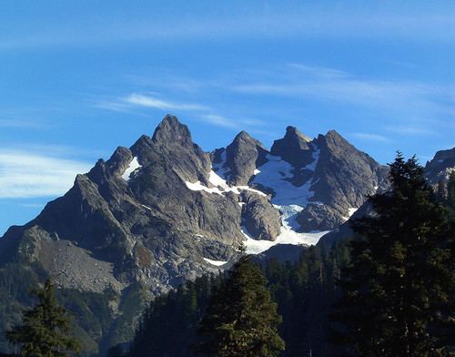
Three Fingers is a mountain located in Snohomish County, Washington. At a height of 6,859 feet (2,091 m), it is the 43rd-tallest mountain in the state, and is also part of the Cascade Range. The name "Three Fingers" refers to the mountain's three summits. It is a prominent and recognizable landmark in northern Snohomish County.
Map of Three Fingers, Washington 98223, USA
The first ascent of the mountain came in 1929, by Darrington-based mountaineers Harry Bedal and Harold Engles. A fire lookout, consisting of a 14-by-14-foot (4.3 m × 4.3 m) wood cabin, was built on the southernmost peak by Bedal, Engels, and Frank Benesh, and was seasonally staffed from 1933 until 1942. Supposedly, the top 15 feet (4.6 m) of the southern peak was blasted for the cabin, lowering the mountain's height in the process. It was abandoned and later rebuilt by local mountaineering groups in the 1960s and 1980s. The lookout was added to the National Register of Historic Places in 1987, alongside other structures in the Mount Baker-Snoqualmie National Forest. The roof was replaced in 2015 using materials delivered via helicopter by the Snohomish County Sheriff's Office.
The mountain is used for recreational climbing, with a 15-mile-long (24 km) round-trip trail originating on the east side at a trailhead on the Mountain Loop Highway.